Write to the booksellers
-
Type
Book (1131)
Drawings (1)
Magazine (13)
Maps (59)
-
Latest
Last 3 days (2)
Last month (21)
Last week (11)
-
Language
English (1)
French (1199)
German (3)
Portuguese (1)
-
Century
16th (4)
17th (30)
18th (57)
19th (135)
20th (238)
21st (56)
-
Countries
Belgium (270)
Brazil (1)
Canada (4)
China (1)
Côte d'Ivoire (12)
France (692)
Netherlands (1)
Switzerland (223)
-
Syndicate
ALAC (4)
ILAB (352)
NVVA (131)
SLACES (131)
SLAM (159)
SNCAO (2)
HEMEL EN AARDE. WERELDEN VAN VERBEELDING.
Amsterdam, Uitgeverij John Benjamins, 1994 Geillustreerde cover, frontispice, 17x24 cm., 280 pp. en XLIX kleurenillustraties. ISBN 9027220891.
Begeleidend boek bij de gelijknamige tentoonstelling in het Bonnefantenmuseum te Maastricht ( 23 november 1991 - 23 februari 1992 ).
Les élections de comenge, d’Esterac, partie de celles de rivière Verdun & d’Armagnac, le Pays des quatre Vallées, le Nébouzan et le Comté de Foix
1695, à Paris chez l'Auteur. 65x47cm (marges à ras). Carte réalisée par Jaillot. Épreuve originale de 1695 tirée de l'Atas François. Colorisation des limites datant de l'époque. Deux restaurations au coin gauche de la marge supérieure. Pliure verticale au milieu de la feuille. Brunissure normale. Charmant exemplaire
Alexis-Hubert Jaillot (1632-1712) est un ingénieur géographe et cartographe français, imprimeur à Paris, de la fin du XVIIe siècle et du début du XVIIIe siècle, au service du roi Louis XIV.
Dislocations: Maps, Classical Tradition, and Spatial Play in the European Middle Ages
, Brepols, 2020 Hardback, xii + 347 pages, Size:152 x 229 mm, Illustrations:42 col., Language: English. ISBN 9780888442185.
Summary In Europe, during the Middle Ages, classical Greek and Roman geography continued to provide the fundamental structure for knowing the world's places and peoples. From encyclopedic compendia such as the Natural History of Pliny the Elder and its redaction in Julius Solinus's Polyhistor to the works of canonical Roman poets such as Virgil, Ovid, and Lucan, the geographical content of antique texts invited study and explication. Yet medieval authors well knew that classical spatial order, itself full of lacunae, only infrequently corresponded to their own reality. Dislocations: Maps, Classical Tradition, and Spatial Play in the European Middle Ages considers the ways in which medieval and, later, humanist geography absorbed and reinvented classical spatial models in order to address key questions of historical change, migration, and emerging national, regional, and linguistic identities. Drawing on a wide range of literary texts, maps, and geographical descriptions - and utilising the ancient but now largely discarded scholarly genre of the dialogue - Dislocations argues that medieval spatial representation was complex and richly textured, whether in the form of a careful gloss in a manuscript of Lucan's Civil War, or as the exuberant sexualized allegories of the fourteenth-century papal notary Opicinus de Canistris. The book also explores a further kind of dislocation: the surprising connections between medieval geographical thought and twentieth- and twenty-first-century visual arts, including Dadaism and the remarkable Mappamundi Suite of the Gujarati artist Gulammohammed Sheikh. While past spatial orders may be relegated to obscurity, they just as often linger - in archives, memories, and ruins - to be retrieved and reanimated in revealing ways.
"Historique de la cartographie (2 volumes); tome 1 : Texte; tome 2 : Planches."
Paris, Eyrolles, 1973. 21 x 27, 2 volumes, tome 1 : v-109-iii-42 pages, tome 2 : 77 planches, broché, très bon état (sauf cachet d'ex-propriétaire).
"Institut Géographique National; Ecole Nationale des Sciences Géographiques."
Les Grandes Alpes dans la cartographie. 1482-1885. Vol. I : Histoire de la cartographie alpine.
Grenoble, éd. Libris, 2005, in-4to, 359 p., richement ill., reliure toile avec jaquette illustrée sous emboîtage. Etat neuf.
1ère édition, illustrée de 433 cartes en noir et en couleurs, et de nombreuses illustrations (portraits, fac-similés) dans le texte. Cette nouvelle version de l'ouvrage de 1974 est entièrement refondue et considérablement augmentée.Ouvrage de référence sans rival sur la cartographie des Alpes, dans une élégante présentation, avec une riche iconographie.
(SLACES, NVVA)
Phone number : 41 (0)26 3223808
Carte dressée par PELLEGRIN.-
Nice. Grasse. Imbert. 1906. Carte topographique couleur au 250000° de 390 x 475mm. (24).
AMIS DU MUSÉE DES SALORGES, GAUTHIER Joseph-Stany, jean Bruneau, Charles Viaud
Reference : 25656
(1978)
CAHIERS DES SALORGES - NUMÉRO 18
Nantes Imprimerie Marthe Chantreau et Compagnie 1978 -in-4 broché revue (magazine) in-quarto, première de couverture illustrée (front cover illustrated), illustrations : bien documenté (well-documented), sans pagination (unpaginated), sans date (1978) à Nantes Imprimerie Marthe Chantreau et Compagnie,
extrait du sommaire (contents) : Numéro 18 : A l'Ecole Bretonne de Cartographie Marine et de Navigation, par Georges Brouscon du Conquet (1543-1548) par le docteur Dujardin-Troadec (6 pages) + Un Charpentier de Navires (3 pages) + La Chasse aux Merles, récit par Jacques ANTONIETTI (9 pages) + La Revolte des Noirs du "Regina-Coeli" (14 pages) par Emmanuel MAUGAT + vieilles chansons à l'embouchure de la Loire par Fernand Guériff (8 pages) + Orages - récit par le commandant Aubin (3 pages) ....... bel exemplaire .... en trés bon état (very good condition) + joint : un grand article découpé dans Presse Océan du 9 octobre 1959 intitulée : "Toute l'histoire contemporaine de Nantes contée par deux boites de conserves au Musée des Salorges", en trés bon état
Plan des Ports d'Amsterdam et de Rotterdam. 1886.-
Tiré de l'Atlas des Ports étrangers. Paris. Imprimerie Nationale. 1886. Grand plan de 54 x 33 cm plié en 3 volets, gravé par A. Simon, publié par le Ministère des Travaux Publics. Impression en noir et bleu. Bords de feuille lgt poussiéreux sinon bon état.
Plan de Paris à l'échelle de 2 Millim. pour 25 Mètres indiquant les Nouveaux percements et les changements de noms de Voies publiques. Avec plans supplémentaires pour les Bois de Boulogne et de Vincennes.-
Paris. Andriveau-Goujon. 1869. Très grand plan couleurs (102 x 83 cm) entoilé et remplié in-8 (146 x 208mm). Toile muette, brunie, excellent état de ce magnifique plan de Paris.
PLAN Géométral de PARIS et de ses agrandissements à l'échelle de 1/10.000).
Louis Antoine Paris 1859 1 vol. Feuille entoilée de 216 x 102 cm; repliée au format in-8 sous étui papier avec pièce de titre en veau cerise.
Premier plan gravé en couleurs par Rousset, rectifié par Potiquet, indiquant les nouveaux percements et les changements de noms de voies publiques, divisant la capitale en 20 arrondissements et 80 quartiers. Joint à notre exemplaire 4 plans indicatifs d'extension des limites de Paris entoilés: - Délimitation provisoire des 1er et 2ème arrondissements (51 x 34 cm). - Délimitation provisoire des 6ème et 7ème arrondissements (51 x 34 cm). - Délimitation provisoire des 8ème et 16ème arrondissements (69 x 34 cm). - Délimitation provisoire des 5ème, 13ème et 14ème arrondissements (102 x 34 cm). Bel exemplaire.
250 views: Isle of Wight and neighbourhood
sd rigide Published by Rock Bros., Ltd., London - sans date - In-4 cartonné - Sans pagination

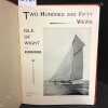
Bon état - Frottements sur les coins et les coiffes Bon
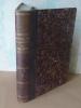
Géographie Nationale illustrée de la France et de ses Colonies, illustrée de nombreuses cartes et gravures et suivie d'une géographie générale du globe, Paris, Librairie Géographique et Scientifique, sans date (1877).
1 volume grand in-8° relié demi-basane marron, dos lisse, faux nerfs et titre doré, basane un peu usagée, deux minuscules trous de vers, petites traces de restauration sur le papier en table des matières, quelques rares rousseurs , 644 p. + gravures et cartes dont une en couleurs. BEL ÉTAT.
Phone number : 06.31.29.75.65
Aperçu historique, statistique et topographique sur l’État d’Alger, à l’usage de l’Armée Expéditionnaire d’Afrique.
Paris, Ch. Piquet, 1830. Texte + Atlas, complet. In-12, 10,5 x 17,5 cm (texte) ; In-folio oblong, 36 x 28 cm. Reliure postérieure pastiche en demi-veau fauve et coins crème en vélin, dos lisse orné de filets à froid et roulettes dorées, pièce de titre en maroquin noir, tranches du volume de texte marbrées. viii, 238 pp. ; 21 pl. (atlas). Deuxième édition, publiée la même année que l’originale. « La première édition de cet Aperçu a été envoyée à l’armée expéditionnaire d’Afrique. On trouvera, à la fin de celle-ci, quelques plans nouveaux, et, dans le texte ou en appendice, quelques additions que de nouvelles recherches nous ont mis à même de présenter au lecteur ». L’atlas contient 7 cartes ou plans gravés, dont 6 dépliants (2 établis d’après les relevés du Capitaine Boutin) et 14 planches lithographiées, dont plusieurs issues de la collection du Colonel Rottiers représentant des vues et des costumes, le tout monté sur onglets.« Ouvrage publié par le Dépôt Général de la Guerre à l'usage de l'armée expéditionnaire d'Afrique, qui quitta le port de Toulon le 25 mai 1830, en direction d'Alger. Il fut rédigé par le géographe Charles Piquet, en grande partie d'après le rapport du capitaine Boutin, envoyé en mission d'espionnage, en 1808, dans la régence d'Alger ». Gay, 852 et 873 ; Tailliart, 1455. Ex-dono JJL de Querelles sur la première carte.
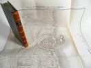
Page de titre de l’atlas absente, quelques rares rousseurs sur les planches qui comportent également, pour certaines, d’anciennes restaurations liées à de discrètes déchirures, sinon bel exemplaire, le plus complet que nous ayons trouvé. - Clients Livre Rare Book : Les frais postaux indiqués sont ceux pour la France métropolitaine et la Corse, pour les autres destinations, merci de contacter la librairie pour connaître le montant des frais d'expédition, merci de votre compréhension. Livre Rare Book Customers : The shipping fees indicated are only for France, if you want international shipping please contact us before placing your order, thank you for your understanding. - Frais de port : -Colissimo France 11 € -Colissimo International (Union Européenne + Suisse : 23 €) (Reste du Monde : 55 €) -Mondial Relay France 7 €
Phone number : +33 6 18 71 03 67
Nouveau Plan de la ville de Paris, chez le Roi libraire -1827
1 carte sur papier chiffon de 305 cm de haut sur 452 cm de large. Petite déchirure sur 7cm en partie supérieure, carte polychrome.
Phone number : 06.31.29.75.65
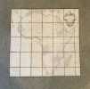
Plan densemble Commune de Villars sur Glâne 1938. Mensuration cadastrale Suisse. 1:5000 1cm=50m. Levé par Jean Ansermot, géomètre. Image 73.5x103 cm.
1938 73.5x103 cm
Image disp.
(SLACES, NVVA)
Phone number : 41 (0)26 3223808
groote kaart van Amsterdam in 1544 van Kornelis Antoniszoon in twaalf bladen / ingekaderd. Behoorende bij het vijfde deel der Geschiedenis van Amsterdam
Amsterdam, Van Holkema , 1885 Amsterdam, Tj. van Holkema,, 1885, ingelijst in frame.
12 losse gekleurde lithografische platen in fraaie lijst ingekaderd, In 14 kleuren op Hollandsch papier gedrukt door Tresling & Co. te Amsterdam. Boek in linnen is erbij. afmeting lijst; 1460x1160mm
Plan de Gibraltar
Très beau plan levé par le chevalier d'Antin (Bertrand d'Antin ?) en 1796. En feuille Très bon Gibraltar 1796 53 x 66 cm

édition originale
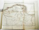
Afrique
Paris, chez l'auteur, 1749, 103,5 x 104 cm (taches, déchirures de la toile).
Carte représentant le continent africain. Elle est imprimée sur papier, rehaussée de couleurs et collée sur un pan de toile brune. Elle comporte une carte des Açores en un insert situé dans son coin supérieur gauche et un cartel dans son coin supérieur droit. Elle a été gravée par Guillaume Delahaye. Voir photographie(s) / See picture(s) * Membre du SLAM et de la LILA / ILAB Member. La librairie est ouverte du lundi au vendredi de 14h à 19h. Merci de nous prévenir avant de passer,certains de nos livres étant entreposés dans une réserve.
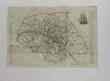
Égypte nommée dans le pays Missir
S.l., s.n. 1765. 74 x 47 cm. (un coin détaché, déchirures, rousseurs).
Carte représentant l'Égypte et le parcours du Nil. Elle est imprimée sur papier, rehaussée de couleurs et collée sur un pan de toile brune. Voir photographie(s) / See picture(s) * Membre du SLAM et de la LILA / ILAB Member. La librairie est ouverte du lundi au vendredi de 14h à 19h. Merci de nous prévenir avant de passer,certains de nos livres étant entreposés dans une réserve.
Promenade autour du monde (pendant les années de 1817, 1818, 1819 et 1820, sur les corvettes du Roi l'Uranie et la Physicienne, commandées par M. Freycinet).ATLAS seul
1822 Paris, Béthune & Plon for Leblanc, (1822). atlas vol. in folio. Sans page de titre ni reliure,broche,mouillures en marge,carte abimée,25 lithographies en noir,dans l’etat
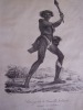
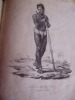
The splendid atlas volume to Jacques Arago’s published account of his voyage to Australia and the Pacific with the Freycinet expedition of 1817-1820.Published in 1822, Arago’s illustrated narrative preceded the official account by two years; and went on to become one of the best-selling voyage books of the nineteenth-century. ‘The text volumes are scarce and the atlas rare’. [Davidson]Arago (1790-1855) was the official artist on Freycinet’s voyage, and is known for the witty and caustic account he later wrote as much as for his fine sketches. Arago was the third of four brothers who excelled in diverse professions, the most notable being his eldest brother François, the scientist and politician. Arago’s undoubted artistic ability attracted the attention of the naval authorities who chose him for the demanding role of draughtsman for the Freycinet expedition. By all accounts a charming, gregarious and eccentric man, these attributes stood him in good stead during the voyage, and are reflected in the sketches he made.The atlas volume is remarkable for its suite of 25 expertly lithographed plates. They include two Australian Aboriginal studies, a landscape in the Blue Mountains outside of Sydney Town, Hawaiian scenes and portraits, native rituals of the Pacific and archaic ruins encountered in the Marianas. les dessins de Jacques Arago, écrivain et dessinateur de l'expédition, reproduits en lithographie dans l'Atlas historique et pittoresque édité en 1822 ,Promenade autour du monde pendant les annees 1817 1818 1819 et 1820 sur les corvettes du roi l'Uranie With a lithographed map of the world and 25 lithographed plates in the atlas, 2 concerning Rio de Janeiro, 5 the Sandwich Islands and 3 Australia. Borba de Moraes I, 44; Sabin 1867; Ferguson 850; Hill, p. 9; Forbes, Hawaiian Nat. Bibliogr. 537-8. Remise de 20% pour toutes commandes supérieures à 200 €
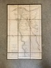
Carte d'Etat Major.-
Révisée en 1906, tirage de 1925. Grande carte (635 x 397 mm) hors marge, dimensions complètes (750 x 540 mm) en noir et blanc, montrant le delta du Rhône au nord de l'étang de Vaccarès. Limites à titre indicatif: à l'ouest le Mas Rabot, à l'est le Marais des Chanoines, au nord le Mas d'Assouan, au sud Silvéréal. Bords de marges un peu abîmées sinon bon état.
Plan de Bordeaux Metropole. Grands Axes - Grands Equipements.
BORDEAUX METROP0LE. Janvier 1996. In-12. En feuillets. Bon état, Couv. convenable, Dos satisfaisant, Intérieur frais. Plan dépliant en couleurs, de 60 x 90 cm.. . . . Classification Dewey : 912-Atlas, cartes et plans
Classification Dewey : 912-Atlas, cartes et plans
Carte région Nord-Pas de Calais
Région Nord Pas de Calais. 2004. In-8. Broché. Bon état, Couv. convenable, Dos satisfaisant, Intérieur frais. Carte dépliante en couleurs, 60x90 cm. Echelle : 1cm = 2,5km.. . . . Classification Dewey : 912-Atlas, cartes et plans

Classification Dewey : 912-Atlas, cartes et plans
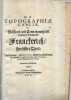
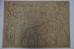
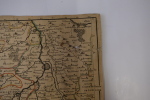
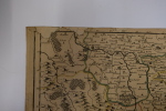
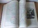
Topographie de la Gaule. Provence.
1 plaquette petit in-folio comprenant 9 cartes, plans et vues. Broché Bon Frankfurt Merian 1661 1 plaquette petit in-folio