 Write to the booksellers
-
Type
Book (1131)
Drawings (1)
Magazine (13)
Maps (59)
-
Latest
Last 3 days (2)
Last month (21)
Last week (11)
-
Language
English (1)
French (1199)
German (3)
Portuguese (1)
-
Century
16th (4)
17th (30)
18th (57)
19th (135)
20th (238)
21st (56)
-
Countries
Belgium (270)
Brazil (1)
Canada (4)
China (1)
Côte d'Ivoire (12)
France (692)
Netherlands (1)
Switzerland (223)
-
Syndicate
ALAC (4)
ILAB (352)
NVVA (131)
SLACES (131)
SLAM (159)
SNCAO (2)
Le lac de Genève.
Genf, H. Georg, 1877. 117 x 81 cm. Karte auf Leinen aufgezogen. Orig.-Leinenmappe.
Mappe fleckig, berieben und bestossen.
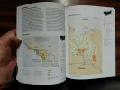
Economies paysannes de La basse vallée du Kamoro (nord-ouest de Madagascar) / Essai de cartographie automatique / Bordeaux - 1976
1976, Université de Bordeaux 3 - Talence, Bordeaux. Fort volume in-4, broché, 285pp. Thèse de doctorat présentée à l'Université Bordeaux 3 - Talence. Nombreuses photographies contrecollées. Quelques annotations au crayon. Riche iconographie. Trace de mouillure sur la couverture sans incidence. Bon exemplaire Photo sur demande.
Breda in kaart
, Breda's Museum 2002, 2002 Hardcover, 112 pagina's, Nederlands, 325 x 245 mm, in goede staat. ISBN 9789080610828.
Breda in kaart. In de cartografische geschiedenis van de stad Breda overheerst één aspect nadrukkelijk: Breda's verleden is in hoge mate door haar status van vestingstad bepaald. Middeleeuwse muren of omvangrijke wallen met bastions domineren de stadsplattegrond den de sporen zijn in het stratenplan, in het bijzonder in de singels rondom de historische binnenstad, tot op de dag van vandaag aanwezig.
Nouveaux regards sur les saisies patrimoniales en Europe à l'époque de la Révolution française
, Brepols, 2021 Paperback, 362 pages, Size:210 x 297 mm, Illustrations:100 col., Language(s):French, English. ISBN 9782503588100.
Summary Il n'est pas rare que soient aujourd'hui remises en question les notions de sécularisation et de décontextualisation des oeuvres d'art qui ont présidé à la création, dans la seconde moitié du XVIIIe siècle, des musées modernes. D'où le risque de vouloir réécrire notre passé en reconsidérant les transferts patrimoniaux qui ont, de tous temps, jalonné l'histoire. Le cas sans doute le plus révélateur est celui des saisies révolutionnaires françaises, à une époque cruciale pour l'éveil de la conscience patrimoniale. Aujourd'hui encore, les passions restent vives en certaines contrées jadis dépouillées de nombreux chefs-d'oeuvre. Poser la question de ces transferts de patrimoine à la fin du XVIIIe siècle sous le seul angle des spoliations apparaîtrait toutefois réducteur, car ce serait oublier combien l'appropriation des oeuvres culturelles par la nation française procédait alors d'une ambition universelle de libération et de promotion de l'art aux fins d'éducation de tous les citoyens. Issues d'un colloque organisé par l'Institut royal du Patrimoine artistique (IRPA) de Bruxelles dans la foulée de son inventaire scientifique des peintures et des sculptures saisies par les révolutionnaires français dans les Pays-Bas autrichiens et la principauté épiscopale de Liège, les contributions proposées réévaluent à leur manière les circonstances historiques, politiques et culturelles des prélèvements d'oeuvres d'art, d'archives et de bibliothèques dans divers pays d'Europe, ainsi que leurs répercussions. TABLE OF CONTENTS Introduction : pour une approche dépasionnée des transferts patrimoniaux - Pierre-Yves Kairis Saisies et restitutions. Éléments de géopolitique patrimoniale - François Mairesse Jean-Baptiste Descamps et Jean-Baptiste-Pierre Lebrun : deux regards opposés sur le « patrimoine » - Gaëtane Maës Les saisies révolutionnaires à Tournai : un apport essentiel à la connaissance de la peinture à Tournai à l'époque moderne - Nathalie Fraquet Spécificités des prélèvements d'oeuvres d'art par les révolutionnaires « français » à Liège - Pierre-Yves Kairis Paintings from the 'Cabinet du Stathouder' Taken from The Hague to Paris, 1795 - Quentin Buvelot La saisie des dessins lors de la première campagne en Italie, entre 1796 et 1797 : raisons et choix des enlèvements - Federica Mancini L'émergence d'une nouvelle conscience patrimoniale à l'heure des saisies révolutionnaires en Italie : les prises de position d'Henri Reboul (1763-1839) - Gianmarco Raffaelli Commemorating Spolia in Napoleonic France - Nancy Karrels Pourquoi le Tibre est-il à Paris ? Le prétendu échange du Napoléon de Canova - André Gob Le transfert de bibliothèques belges à Paris sous la Convention : légitimité politique, rationalité administrative, travail d'érudits - Cécile Robin Les bibliothèques des anciennes congrégations religieuses à l'origine des fonds patrimoniaux des bibliothèques de l'Université de Liège - Cécile Oger « Aux François étoit réservée la gloire de conserver les productions de ces hommes d'un génie inimitable ». La restauration des tableaux au service de la rhétorique révolutionnaire - Aude Briau La restauration des tableaux enlevés à la Belgique : un enjeu patrimonial majeur - Christine Godfroy-Gallardo Les tableaux flamands et hollandais provenant de « Belgique » dans l' « Inventaire Napoléon » - Guillaume Nicoud Un acteur peu connu de la restitution des tableaux à Anvers : Nicolas-François Beeckmans - Brieuc Beeckmans Papiers dispersés, papiers triés - François Antoine Le sort des archives publiques en Belgique de la fin de l'empire napoléonien au royaume des Pays-Bas (1814-1815) - Pierre-Jean Niebes Les temps juridiques du retable d'Issenheim : dépasser l'étude de cas ? - François Desseilles
Carte Routière et Vicinale du Département de l'Hérault
4 étuis cartonnés, sans nom, 1862-1864 de cartes entoilées et rempliées, La carte est dressée sous l'administration du préfet J.M. Pietri, sous la direction de l'agent-voyer Fenouil. Arrondissement de Montpellier: 8 cartes (1862); Arrrondissement de Lodève: 6 cartes (1862); Arrondissement de Saint-Pons: 6 cartes 1862); Arrondissement de Béziers: 9 cartes (1864). La taille des cartes est de 46,5 cm x 59 cm.

Ensemble bien complet, dans ses étuis d'origine, en très bon état. Peu commun
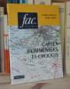
Cartes commentées et croquis, méthodes et exemples, Paris, éditions Nathan, 1993.
1 vol. in-8° br. couv. pelliculée illustrée, 199 p. + cartes et croquis hors et dans le texte, neuf.
Phone number : 06.31.29.75.65
Città di Milano. 1801. Giuseppe Caniani incise.
Plan de Milan (807 x 569 mm), gravé à l’eau-forte, entoilé et dépliant (21 morceaux) qui comprend le projet “Foro-Bonaparte” décrété par une loi du 30 nivôse an IX (20 janvier 1801) et projeté par l’architecte Antolini.
Ce plan est extrêmement précis dans la représentation des blocs et des bâtiments individuels grâce au cadastre contemporain. Il est resté célèbre par la présence du projet monumental et majestueux du “Foro Bonaparte” en forme d’anneau autour du château, il était destiné à accueillir les nouveaux services de la ville selon les principes révolutionnaires introduits par les Français. Il ne sera pas réalisé et lors de l’édition suivante du plan, en 1808, le château et ses alentours seront débarrassés des projets de Bonaparte. rares petites usures à la toile. Bel exemplaire de ce plan historiquement précieux.
Phone number : 06 60 22 21 35
Christian Maps of the Holy Land. Images and Meanings
, Brepols, 2020 Paperback, xxv + 176 pages, Size:216 x 280 mm, Illustrations:62 b/w, 11 col., Language: English. ISBN 9782503585260.
Summary This book offers a way of reading maps of the Holy Land as visual imagery with religious connotations. Through a corpus of representative examples created between the sixth and the nineteenth centuries, it studies the maps as iconic imagery of an iconic landscape and analyses their strategies to manifest the spiritual quality of the biblical topography, to support religious tenets, and to construct and preserve cultural memory. Maps of the Holy Land have thus far been studied with methodologies such as cartography and historical geography, while the main question addressed was the reliability of the maps as cartographic documents. Through another perspective and using the methodology of visual studies, this book reveals that maps of the Holy Land constructed religious messages and were significant instruments through which different Christian cultures (Byzantine, Catholic, Protestant, and Greek Orthodox) shaped their religious identities. It does not seek to ascertain how the maps delivered geographical information, but rather how they utilized the geographical information in formulating religious and cultural values. Through its examination of maps of the Holy Land, this book thus explores both Christian visual culture and Christian spirituality throughout the centuries. TABLE OF CONTENTS List of Illustrations Abbreviations Timeline Introduction Part I. Iconic Landscape, Iconic Map Chapter 1. Formation of a Holy Land Chapter 2. Madaba Map: A Visual Portrait of the Holy Land from the Byzantine Period Composition and Content Religious Message Generator of Cultural Memory Map and Pilgrimage The Holy Land Map and Early Christian Art Part II. The Map of the Holy Land in the Latin West Chapter 3. Innovative Western Spiritual Iconographies Twelfth-Century Maps Matthew Paris's Map in his Chronica majora (mid thirteenth century) Grid Maps from the Fourteenth Century Chapter 4. Fifteenth-Century Pilgrims' Maps: Late Medieval Instruments of Devotion Gabriel Capodilista's Map William Wey's Map Bernhard von Breydenbach's Map A Map by an Anonymous Author Part III. Between Pilgrimage and Scripture, Catholicism and Protestantism Chapter 5. Friedrich III's Cartographical Pilgrimage Imagery Lucas Cranach the Elder's Map: A Transitional Image Gotha Panel Chapter 6. Map and Scripture Gerard Mercator's Map of the Holy Land John Speed's Map, Associated with the King James Bible Maps of the Holy Land in the Dutch States-General Bible Justus and Cornelis Danckerts' Map of the Holy Land: A Pictorial Epitome Part IV. Map as Icon: Greek Orthodox proskynetaria from the Ottoman period Chapter 7. Icon of a Land Conclusion Appendices I. Inscriptions on the Madaba Map II. Sites Mentioned in the Pilgrimage Guide of Gesta Francorum Ihrusalem expugnantium (dated to 1101-1104) in Order of Appearance) III. Inscriptions on Three Twelfth-Century Maps of the Holy Land IV. Inscriptions on London, British Library, Add. MS 27376, fols. 188v-189r V. A List of Places in William Wey's Pilgrimage Account (Oxford, Bodleian Library,MS Bodley 565), said to be synchronized with his map of the Holy Land VI. Sites in and around Jerusalem in Bernhard von Breydenbach's Map of the Holy Land Bibliography Index
Carte de la Mélanésie, Micronésie, Polynésie, dessinées et gravées par R. Hausermann.
Supplément du Journal des Missions Catholiques. 1896. Feuille de ca 1060 x 730 mm, pliée en 16, carte de ca 970 x 660 mm. Carte générale centrale de ca 490 x 420 mm, entourée de 24 cartes des différentes îles et archipels. Tirage en rouge sur fond vert pâle. Réparations aux croisements des plis d'origine sans dommage pour la carte. Bon exemplaire.
Sociétés des Fonderies de Pont à Mousson. Usine de Pont à Mousson.
Plan des unités de production de l'usine de Pont à Mousson dépliant (465 x 180 mm) en couleurs (échelle 1/5000e) sur l'ensemble du site, accompagné d'un calque d'architecte détaillant en transparence les machines, installations et équipements pour chaque bâtiment. Ensemble relié sous couverture illustrée. Pont à Mousson, sans date (vers 1930).
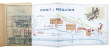
Aucun exemplaire de ce document n'est répertorié. Il manque à la réunion des bibliothèques mondiales en ligne (WorldCat).Bon exemplaire.
Phone number : 33 01 47 07 40 60
TROIS SIÈCLES DE CARTOGRAPHIE EN ÎLE-DE-FRANCE, volume 1.
Les cahiers de l'Institut d'aménagement et d'urbanisme de la région Île-de-France, n° 119, Paris, décembre 1997. In-4, broché, feuillet d'errata, illustrations.
[7135]
POUVREAU Pascale Photographie Marc Deneyer, cartographie Georges Cose et Zoé Lambert.
Reference : 137638
(1997)
Patrimoine industriel.
Couverture souple. Broché. 144 pages.
Livre. Photographie Marc Deneyer, cartographie Georges Cose et Zoé Lambert. Editions L'inventaire, 1997.
"Topographie (instuments), suivi d'un appendice relatif à la topographie expédiée (par O. Roux); Livre 1er : Instruments, description, manuvre, vérification, réglage et précision. Bibliothèque de l'ingénieur de Travaux Publics."
Paris, Dunod, 1925. 12 x 19, 542 pp., 343 figures, 1 planche dépliante, reliure d'édition pleine toile rouge, bon état (couverture insolé, cachet d'ex-prioritaire).
Nederlandse Wereldatlas. De wereld in kaart, woord en beeld.
Amsterdam, DE BRUG, 1959 Faux-lederen band met stofwikkel, 292 pagina's, 31 x 22 cm, NL. *mooie staat, stofwikkel heeft slijtage.
Nederlandse Wereldatlas. De wereld in kaart, woord en beeld.
La RÉPUBLIQUE FRANÇAISE en LXXXIV départemens; Dictionnaire géographique et méthodique destiné aux administrateurs, négocians, gens d'affaire et à ceux qui étudient la géographie de la France.
Editeur [Prudhomme] Paris 1793 1 vol. In-8 de VI 1 f.n.ch. (table) 366 pp. 1 f.n.ch. (avis), demi-veau de l'époque, dos lisse orné, pièce de titre (accroc à la coiffe inférieure, coins émoussés).
Ouvrage dans lequel on trouve pour chaque département les districts et les cantons, un dictionnaire alphabétique des productions et objets de commerce avec une table alphabétique de tous les chef-lieux de cantons. Bon exemplaire orné d'un atlas complet des cartes des 84 départements, au contour rehaussé (dont une repliée : Département du Mont Blanc), petit manque à la carte des Pyrénées orientales. Joint une grande carte générale repliée de la France, gravée par Gilot.
COSMOGRAPHIA. Tabulae
Paris Editions Hier et Demain 1976 grand in folio (46,5x35) 1 volume sous boitage de l'éditeur, dos et plat supérieur titrés, renfermant un fascicule de texte de 24 pages [1], suivi de 27 planches doubles hors-texte en couleurs de cartes. Collection cartographie antique. Collationné complet. Tirage limité à 999 exemplaires numérotés. Bel exemplaire ( Photographies sur demande / We can send pictures of this book on simple request ) poids du colis: 3 kilogrammes, emballage de protection
Très bon Couverture rigide Ed. numérotée
Claudii Ptomlomaei. Cosmographia Tabulae…
Torriana, Paris, Booking International, 1990. In folio (270 x 380) de XVI p. et 27 planches en double page. Cartonnage glacé bleu de l’éditeur, illustration en couleurs sur le plat sup. Etat neuf.
Nouvelle édition de ces 27 cartes en couleurs du manuscrit latin VF. 32 (XVe s.) de la “Cosmographia” de Ptolémée conservé à la Bibliothèque Nationale de Naples, avec une introduction de Lelio Pagani, une bibliographie, des notes et le sommaire des planches. Ce traité rédigé par Ptolémée vers l’an 150, est une compilation des connaissances de la géographie du monde à l’époque de l’Empire romain.
Les noms de terroirs ou la mémoire des lieux.
Maulévrier, éd. Hérault, 6 janvier 1992, in-8, cartonnage souple, couv. ill. en noir éd., 322 pp., nb. plans et cartes en noir, la toponymie de Saint-Sauvant, bibliographie, index, table des illustrations, table des matières, D’où viennent-ils les noms de terroirs, tous ces noms de villages, de fermes, de champs, de bois, de chemins ? Quelles significations, que disent-ils ? Une très Grande étude, une référence ! RARE Très bon état
Oude scheepskaarten en hun makers: hoogtepunten uit vijf eeuwen cartografie.
, Amsterdam, Becht, 1983., Gebonden, blauw linnen, vergulde titel op de rug, originele geillustreerde omslagwikkel in kleur, 38,5x31cm, 143pp, rijkelijk en fraai geillustreerd in kleur en z/w.
De in dit boek afgebeelde scheepskaarten, daterend van begin van de veertiende eeuw tot in de achtiende eeuw, vormen tezamen een overzicht van de verovering van de onbekende kusten der aarde. Verlucht met 67 grote afbeeldingen en vele details.
Carte officielle du Service Géographique de l'Armée 1/200.000.-
France Tourisme. EPOC. Tirage de Janvier 1930. Très grande carte couleurs de 972 x 648 mm repliée en 18 volets de 162 x 216 mm. Publicités et légendes au dos de la carte. Carte sous étui imprimé et un peu insolé. Bon exemplaire.
Carte des royaumes d'Espagne et du Portugal
Paris, Emery, 1823, 1 f. 80,5 x 102 cm, cartonnage rose, étiquette manuscrite (cartonnage défraîchi mais solide, petites déchirures et trous, papier bruni d'un côté, empoussiéré de l'autre).
![Carte des royaumes d'Espagne et du Portugal. [PÉNINSULE IBÉRIQUE]](https://static.livre-rare-book.com/pictures/TVX/21203_2_thumb.jpg)
Carte de la péninsule ibérique comprenant les Baléares dont les limites administratives ont été rehaussées de liserés de couleurs. Elle comprend en insert, une carte de Gibraltar et une de la ville de Cadix. * Membre du SLAM et de la LILA / ILAB Member. La librairie est ouverte du lundi au vendredi de 14h à 19h. Merci de nous prévenir avant de passer,certains de nos livres étant entreposés dans une réserve.
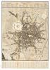
Atlas physique et Politique de la France pour servir à L'Étude de la Géographie et de L'Histoire de France (---) Paris, Dezobry, E. Magdeleine et Cie. 1857.
1 vol. in-4° rel. demi-toile bleue, plats de papier illustré (usage avec nombreuses taches et petits manques), 6 p. la carte N°25 France Politique Actuelle n'est pas présente. 24 cartes coloriées. Quelques petites taches en marge sans gravité. Très bon état interne. Extérieur usagé.
Phone number : 06.31.29.75.65
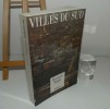
Villes du Sud. Paris. Balland. Paris. 1990.
1 volume in-8° broché, couverture illustrée, 404 p. + illustrations. Très bon état. Nom de propriétaire manuscrit en page de faux-titre.
Phone number : 06.31.29.75.65
Les théories tétraédristes de la forme de la terre. Thèse.
Roma, Tip. Madre di Dio 1936, 225x155mm, 158pages, broché.
Pour un paiement via PayPal, veuillez nous en faire la demande et nous vous enverrons une facture PayPal
Russie, - Un vertige de puissance. Une analyse critique et cartographique
Paris, La Découverte, février 2023, 19 x 25, 192 pages cousues sous couverture souple illustrée. Nombreuses cartes couleurs.

Quatrième de couverture salie (voir photo).