 Write to the booksellers
FREZIER (Amédée François)
Relation du Voyage de la Mer du Sud aux côtes du Chily et du Pérou, Fait pendant les années 1712, 1713 & 1714, Dédiée à S.A.R. Monseigneur Le Duc D'Orléans, Régent du Royaume.
Paris, Nyon - Ganeau - Quillau, 1716. 1716 1 vol. in-4 (253 x 195 mm) de : XIV (titre, épître, avertissement, "explication de quelques termes de marine"); 298 pp. (dont table); [1] f. (approbation, privilège, fautes à corriger); 37 planches numérotées (rousseurs claires éparses). Demi-basane, plats recouverts de papier marbré, dos à cinq nerfs orné, titre de maroquin rouge, tranches rouges (jolie reliure pastiche, corps d'ouvrage d'origine).
Reference : 5681
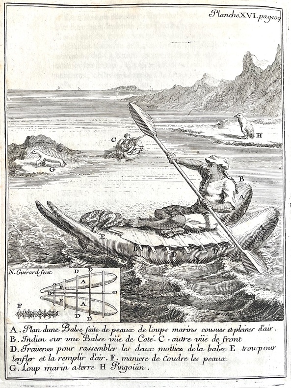
Edition originale de ce classique de la littérature de voyage de la Mer du Sud. Dabord prisé pour son apport cartographique, (Frézier est lauteur de la première carte fiable de la rive orientale du Pacifique) il continue dintéresser aujourdhui pour ses observations dhistoire naturelle, ethnologiques et sociales. Frézier (1682-1737), lieutenant dinfanterie, nommé ingénieur ordinaire en 1707, se distingua en suggérant au Maréchal Villars la « manuvre de Denain » qui mit fin à la guerre de Succession dEspagne. Nommé officier du génie, il est choisi par le ministre des Fortifications, Peletier de Souzy pour un voyage dexploration dans les mers du Sud : mission de reconnaissance des ports et fortifications espagnoles sur la côte occidentale de lAmérique du Sud. La France qui traverse une crise économique, se renseigne sur les riches colonies du Roi dEspagne : leurs ports, relations commerciales et ressources minières. Après un premier départ avorté, Frézier embarque comme simple particulier sur un navire marchand, le Saint-Joseph, commandé par le capitaine Duchesne-Battas, de 350 tonneaux, 150 hommes et 36 canons (confidentialité de la mission oblige) en janvier 1712. Ils atteignent Concepción en juin 1712. Fin septembre Frézier part pour huit mois à Valparaiso doù il visite Santiago. En mai 1713, il repart pour le Nord, visite Serena, la côte de Copiapo, et arrive jusqu'à Callao, le port de Lima. Il revient à Concepción, où il séjourne de novembre 1713 à février 1714, puis s'embarque pour la France sur un marchand qui arrive à Marseille en août 1714. Sa Relation apporta de grandes avancées dans le domaine cartographique sur une partie du monde dangereuse et mal connue, mais primordiale pour les communications et le commerce de lépoque : le Détroit de Magellan, le Cap Horn, lîle des Etats, la Terre de Feu et les Malouines. Bougainville et La Pérouse le citent comme une référence dans leurs relations quand ils passent dans ces zones. Louvrage donne un compte-rendu précis de toutes les fortifications, batteries et des troupes de ces ports. Mais lauteur fait également un travail de botaniste, de minéralogiste (lors de son analyse des mines dor et dargent), et même déconomiste et dethnologue. Il dépeint dune plume acerbe les colons quil juge paresseux et brutaux, se reposant sur leurs esclaves comme lillustre la gravure XXXV : « Nègres portant le serpentin ». En effet, ses talents de dessinateur ne se limitent pas à la cartographie, louvrage comporte six planches dhistoire naturelle, dont le Fraisier blanc dont lauteur ramena quelques plants en Europe, et sept planches représentant des habitants des divers pays visités, en costumes typiques, dans des activités quotidiennes. Les plans dépliants des villes sont souvent complétés par des vues, comme cest le cas pour Callao, Concepción, Valparaíso, La Serena, Salvador de Bahía, and Angra (Azores). Bel exemplaire, bien complet des planches de cette relation majeure. 1 vol. 4to (253 x 195 mm) of : XIV (title, epistle, warning, "explication de quelques termes de marine"); 298 pp. (including table); [1] f. (approbation, privilege, errors to be corrected); 37 numbered plates (scattered light foxing). Half sheep, boards covered with marbled paper, five-ribbed spine decorated, red morocco title, red edges (attractive pastiche binding, original book block). First edition of this classic of South Sea travel literature. Initially prized for its cartographic contribution (Frézier was the author of the first reliable map of the eastern shore of the Pacific), it continues to interest readers today for its natural history, ethnological and social observations. Frézier (1682-1737), infantry lieutenant, was appointed ingénieur ordinaire in 1707, and distinguished himself by suggesting to Marshal Villars the "Denain maneuver" that ended the War of the Spanish Succession. Appointed an engineering officer, he was chosen by the Minister of Fortifications, Peletier de Souzy, for a voyage of exploration in the South Seas: a reconnaissance mission of Spanish ports and fortifications on the west coast of South America. France, in the midst of an economic crisis, sought information on the King of Spain's rich colonies: their ports, trade relations and mineral resources. After a first abortive departure, Frézier embarked as a private individual on a merchant ship, the Saint-Joseph, commanded by Captain Duchesne-Battas, of 350 tons, 150 men and 36 cannons (mission confidentiality required) in January 1712. They reached Concepción in June 1712. At the end of September, Frézier sailed for eight months to Valparaiso, from where he visited Santiago. In May 1713, he headed north again, visiting Serena, the Copiapo coast and as far as Callao, the port of Lima. He returned to Concepción, where he stayed from November 1713 to February 1714, before setting sail for France on a merchant ship that arrived in Marseille in August 1714. His Relation brought major advances in cartography to a dangerous and little-known part of the world, which was vital for communications and trade at the time: the Magellan Strait, Cape Horn, the Isle of the States, Tierra del Fuego and the Falklands. Bougainville and La Pérouse cited it as a reference in their relations when passing through these areas. The book gives a precise account of all the fortifications, batteries and troops in these ports. But the author is also a botanist, a mineralogist (in his analysis of the gold and silver mines), and even an economist and ethnologist. With an acerbic pen, he depicts the colonists as lazy and brutal, relying on their slaves, as illustrated by engraving XXXV: " Negroes carrying the serpentine ". Indeed, his talents as a draughtsman were not limited to cartography: the work includes six plates of natural history, including the white strawberry tree, some plants of which he brought back to Europe, and seven plates depicting the inhabitants of the various countries he visited, in typical costumes, engaged in everyday activities. The fold-out city maps are often complemented by views, as is the case for Callao, Concepción, Valparaíso, La Serena, Salvador de Bahía, and Angra (Azores). A fine copy, complete with plates of this major relationship.
Bookseller's contact details
J-F Letenneur Livres Rares
M. Jean-François Letenneur
11 bd du tertre Gondan
35800 Saint Briac sur Mer
France
librairie@jfletenneurlivresrares.fr
06 81 35 73 35