 Write to the booksellers
JEFFERYS (Thomas);
[GRAVELINES] A plan of Gravelines, with the new canal and the course of the river Aa to the sea.
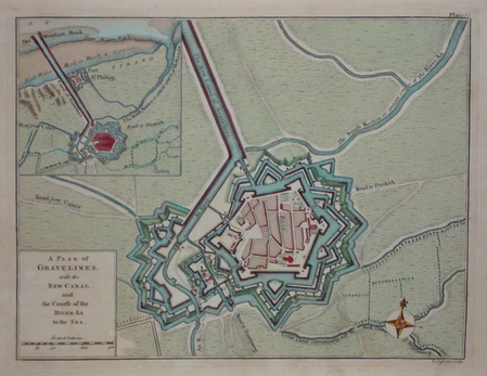
London 1774 189 x 250 mm.
Reference : LBW03d42
Très beau plan gravé figurant la ville fortifiée de Gravelines et le nouveau canal, issu de l'atlas intitulé A Description of The Maritime Parts of France, ouvrage considérable donnant une description détaillée des côtes françaises, de Dunkerque à Nice. Graveur, géographe et éditeur à Londres, Thomas Jefferys (1710-1771) fut l'un des principaux cartographes anglais de la seconde moitié du dix-huitième siècle. Nommé géographe du prince de Galles en 1748, puis de George III, il se spécialisa dans les cartes d'Amérique du Nord et des Antilles, qu'il publia entre 1751 et 1768. Bel exemplaire brillamment colorié à l'époque. Rare dans de tels coloris.
Bookseller's contact details
Librairie Le Bail
Didier Le Bail
13 rue Frédéric Sauton
75005 Paris
France
33 01 43 29 72 59
Payment mode
Sale conditions
Conditions de vente conformes aux usages et aux règlements du Syndicat de la Librairie Ancienne et Moderne (SLAM) et de la Ligue Internationale de la Librairie Ancienne (LILA). Paiements acceptés : cartes bancaires, via un lien de paiement, chèques, virements Conditions of sale in accordance with the practices and regulations of the Syndicat de la Librairie Ancienne et Moderne (SLAM) and the International League of Antiquarian Booksellers (ILAB). Payments accepted: credit cards, via payment link, checks, and bank transfers.