 Write to the booksellers
PERRIN (Maurice).
[BERLIN] Plan de Berlin.
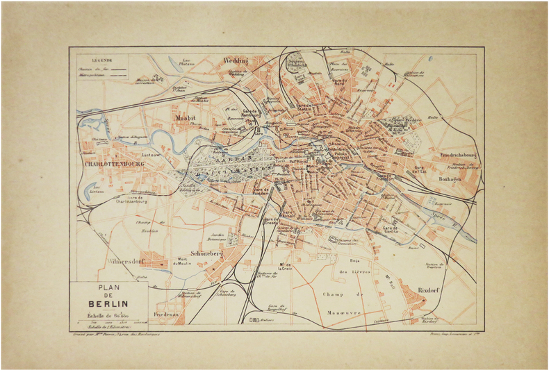
Paris, [1890]. 157 x 226 mm.
Reference : LBW-8600
Plan de Berlin, gravé en trois couleurs par Maurice Perrin pour l'Atlas de la nouvelle géographie moderne d'Émile Morieu et Maurice Perrin, publié à Paris en 1890. Le plan, dressé au 1,60,000e, figure le métropolitain et les chemins de fer. Bel exemplaire.
Bookseller's contact details
Librairie Le Bail
Didier Le Bail
13 rue Frédéric Sauton
75005 Paris
France
33 01 43 29 72 59
Payment mode
Sale conditions
Conditions de vente conformes aux usages et aux règlements du Syndicat de la Librairie Ancienne et Moderne (SLAM) et de la Ligue Internationale de la Librairie Ancienne (LILA). Paiements acceptés : cartes bancaires, via un lien de paiement, chèques, virements Conditions of sale in accordance with the practices and regulations of the Syndicat de la Librairie Ancienne et Moderne (SLAM) and the International League of Antiquarian Booksellers (ILAB). Payments accepted: credit cards, via payment link, checks, and bank transfers.
5 book(s) with the same title
Reference : alba9cb91aeab74e14e
Zuckerman S.I. The Russian Couriers Guide. A booklet with a plan for Berlin. I
Zuckerman S.I. The Russian Couriers Guide. A booklet with a plan for Berlin. In Russian /Tsukerman S.Ya. Putevoditel Russskogo kurera. Buklet s planom Berlina. Berlin Editions of the Russian Courier 1912 31x49 sm. We have thousands of titles and often several copies of each title may be available. Please feel free to contact us for a detailed description of the copies available. SKUalba9cb91aeab74e14e.
Kiesslings Berliner Baedeker. Praktischer Führer durch Berlin und Umgebung. Mit Plan von Berlin
Chez l'auteur. 1907. In-12. Broché. Etat d'usage, Couv. défraîchie, Dos abîmé, Papier jauni. 124 pages. Texte en allemand. Une carte de Berlin en couleur. Rousseurs. Coins abîmés.. . . . Classification Dewey : 430-Langues germaniques. Allemand
Classification Dewey : 430-Langues germaniques. Allemand
Plan de Berlin
FAYARD. 1877. In-Folio. En feuillets. Bon état, Couv. convenable, Dos satisfaisant, Intérieur frais. Carte en couleurs, en double-planches scindée en deux (déchirure).. . . . Classification Dewey : 912-Atlas, cartes et plans
Provenant de l'Atlas Universel, contenant la Géographie physique, politique, historique, théorique, militaire, industrielle, agricole & commerciale du Monde avec la statistique la plus récente et la plus complète. Dressée par Vuillemin, Charles Lacoste, Monin et Clerot. Gravé sur acier par Lacouchy, Lorsignol et Haussermann. Classification Dewey : 912-Atlas, cartes et plans
BEROLINEUM, OU NOUVELLE DESCRIPTION DE BERLIN. OUVRAGE INDISPENSABLE POUR CONNAITRE ET VISITER EN PEU DE TEMPS CE QU'IL Y A DE PLUS CURIEUX TANT DANS LA CAPITALE QU'AUX ENVIRONS; AVEC UN PLAN ENLUMINE DE LA VILLE DE BERLIN ET LA VUE DU NOUVEAU PALAIS A POSTDAM.
BERLIN. CHEZ GUILLAUME OEHMIGKE LE CADET. 1805. IN-8 (13 X 20 X 2,5 CENTIMETRES ENVIRON) DE X + (2) + 304 ET (2) PAGES, RELIURE D'EPOQUE 1/2 VEAU MARBRE, DOS LISSE ORNE DE CAISSONS A FLEURONS DORES, TITRE DORE SUR ETIQUETTE MAROQUIN BRUN, TRANCHES MARBREES. ILLUSTRE D'UN PLAN DE BERLIN REPLIE EN COULEURS ET D'UNE VIGNETTE DE TITRE OVALE REPRESENTANT LE PALAIS DE POSTDAM. EDITION ORIGINALE FRANCAISE. PETITES TRACES D'USURE EXTERIEURE SANS GRAVITE, SINON BEL EXEMPLAIRE.
Reference : albb1c84a3cf312b5f0
A plan for the city of Berlin. In Russian (ask us if in doubt)/Plan goroda Berli
A plan for the city of Berlin. In Russian (ask us if in doubt)/Plan goroda Berlina. 1907. 229-287 mm. We have thousands of titles and often several copies of each title may be available. Please feel free to contact us for a detailed description of the copies available. SKUalbb1c84a3cf312b5f0