 Write to the booksellers
THOMAS (George).
[ÉCOSSE/ÎLES SHETLAND] Carte des îles Shetland.
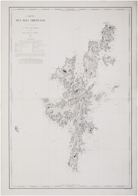
[Paris], Dépôt-Général de la Marine, 1847. 902 x 610 mm.
Reference : LBW-7593
Belle et grande carte marine figurant l'archipel écossais des Shetland, levée en 1833 par le capitaine George Thomas à bord du HMS Navigator. La carte est accompagnée d'un vocabulaire anglais-français des termes de cartographie marine les plus courants. Les profondeurs marines sont indiquées le long des côtes. Capitaine de la Royal Navy, George Thomas (1781-1850) fut l'un des premiers arpenteurs des côtes de la Grande-Bretagne. Bel exemplaire.
Bookseller's contact details
Librairie Le Bail
Didier Le Bail
13 rue Frédéric Sauton
75005 Paris
France
33 01 43 29 72 59
Payment mode
Sale conditions
Conditions de vente conformes aux usages et aux règlements du Syndicat de la Librairie Ancienne et Moderne (SLAM) et de la Ligue Internationale de la Librairie Ancienne (LILA). Paiements acceptés : cartes bancaires, via un lien de paiement, chèques, virements Conditions of sale in accordance with the practices and regulations of the Syndicat de la Librairie Ancienne et Moderne (SLAM) and the International League of Antiquarian Booksellers (ILAB). Payments accepted: credit cards, via payment link, checks, and bank transfers.