 Write to the booksellers
TUR (Paul Henri) & BOREUX (Léon Claude).
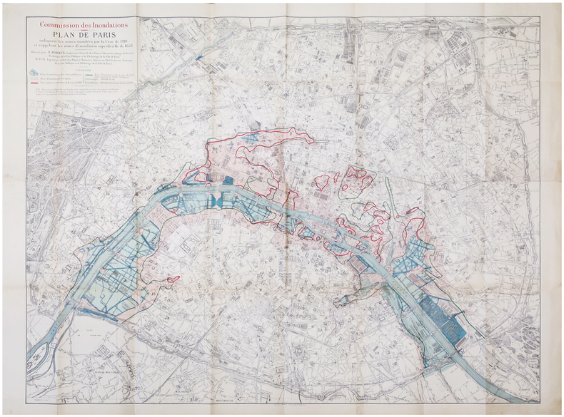
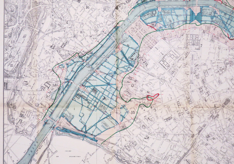
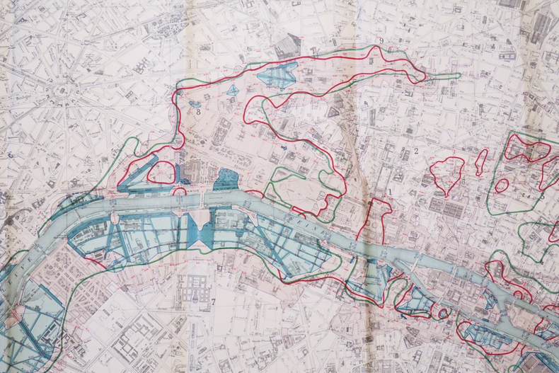
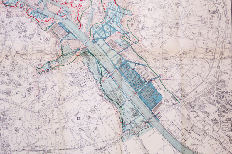
[INONDATIONS de 1910] Commission des Inondations. Plan de Paris indiquant les zones inondées par la crue de 1910 et rappelant les zones d'inondation superficielle de 1658.
Paris, Librairie Chaix, 1910. 0,93 x 1,18 m.
Reference : LBW-6846
Très rare plan mural de Paris, montrant les zones inondées par la crue de 1910 et les zones d'inondation de 1658. Il a été dressé pour la Commission des Inondations par Léon Claude Boreux, inspecteur général des Ponts et Chaussées, chargé du Service Technique de la Voie Publique et de l'Éclairage de la Ville de Paris, et Paul Henri Tur, ingénieur en chef des Ponts et Chaussées, et adjoint de Boreux. En bleu sont signalées les zones d'inondation des voies publiques, en saumon, les zones d'inondation des caves. Les limites des zones situées en contrebas de la crue de 1910 sont indiquées par un trait rouge, les limites des zones d'inondation de la crue de 1658 par un trait vert. Les cotes rouges indiquent l'altitude au sol, les cotes bleues, l'altitude atteinte par la crue de 1910. La crue de la Seine de 1910, souvent qualifiée de crue centennale (soit celle qui peut arriver en moyenne une fois par siècle), est le plus important débordement connu de la Seine après celui de 1658. Il a touché la plus grande partie de sa vallée et, bien qu'il n'ait pas été très meurtrier, a causé d'importants dommages à l'économie régionale, en particulier à Paris. Le 28 janvier 1910, la Seine atteignait son niveau maximal de 8,62 mètres sur l'échelle hydrométrique du pont d'Austerlitz. Les inondations atteignirent le faubourg Saint-Antoine, le nord des Champs-Elysées, jusqu'à la gare Saint-Lazare. En février 1910, aussitôt après la catastrophe, une Commission des Inondations fut constituée au Ministère de l'Intérieur, afin d'examiner divers projets propres à défendre Paris contre une nouvelle atteinte : surélever les quais, prévoir des barrages réservoirs, creuser le lit du fleuve, ou encore, implanter des stations de pompage. La crue de mars 1658, quant à elle, fut la plus grande inondation enregistrée à Paris. Elle fut plus élevée de 30 à 50 cm que celle de 1910, atteignant 8,96 m à l'endroit du futur pont d'Austerlitz. L’eau inonda la place de Grève, actuelle place de l’Hôtel-de-Ville, le quartier des Halles et la rue Saint-Honoré. Sur la rive gauche de la Seine, elle a atteint les faubourgs Saint-Marcel et Saint-Victor, ainsi que le quartier Saint-Bernard. Bel exemplaire, replié. Pinon & Le Boudec, p. 120. Very rare wall map of Paris, showing areas flooded by the 1910 flood and the 1658 flood areas. It was drawn for theCommission des Inondationsor Flood Commission, by Léon Claude Boreux, Inspector General of thePonts et Chaussées, in charge of the Technical Service of Public Roads and Lighting of the City of Paris, and Paul Henri Tur, Chief Engineer of thePonts et Chaussées, and assistant of Boreux. The areas of flooding of public roads are shown in blue, the areas of flooding of cellars in salmon. The limits of the zones located below the 1910 flood are indicated by a red line, the limits of the flood zones of the 1658 flood by a green line. The figures in red indicate the altitude on the ground, the figures in blue, the altitude reached by the 1910 flood. The flood of the Seine of 1910, often described as a centennial flood (that can happen on average once a century), is the most important known overflow of the Seine after that of 1658. It affected most of its valley and, although it was not very deadly, it caused significant damage to the economy of the region, especially in Paris. On January 28, 1910, the Seine reached its maximum level of 8.62 meters on the hydrometric scale of the Pont d'Austerlitz. The floods reached the Faubourg Saint-Antoine, north of the Champs-Elysées, as far as the Saint-Lazare station. In February 1910, immediately after the disaster, a Flood Commission was set up at the Ministry of the Interior to examine various projects designed to defend Paris against a new attack: raising the quays, providing for reservoir dams, digging the bed of the river, or establish pumping stations. The flood of March 1658, meanwhile, was the largest flood recorded in Paris. It was 30 to 50 cm higher than that of 1910, reaching 8.96 m at the location of the future Pont d'Austerlitz. The water flooded the Place de Grève, now Place de l'Hôtel-de-Ville, the Halles district and the rue Saint-Honoré. On the left bank of the Seine, it reached the faubourgs Saint-Marcel and Saint-Victor, as well as the district Saint-Bernard. Beautiful copy, folded. Pinon & Le Boudec, p. 120; not in Vallée.
Bookseller's contact details
Librairie Le Bail
Didier Le Bail
13 rue Frédéric Sauton
75005 Paris
France
33 01 43 29 72 59
Payment mode
Sale conditions
Conditions de vente conformes aux usages et aux règlements du Syndicat de la Librairie Ancienne et Moderne (SLAM) et de la Ligue Internationale de la Librairie Ancienne (LILA). Paiements acceptés : cartes bancaires, via un lien de paiement, chèques, virements Conditions of sale in accordance with the practices and regulations of the Syndicat de la Librairie Ancienne et Moderne (SLAM) and the International League of Antiquarian Booksellers (ILAB). Payments accepted: credit cards, via payment link, checks, and bank transfers.