 Write to the booksellers
DÉPÔT GÉNÉRAL DE LA MARINE.
[ANTIBES] Plan du port d'Antibes et des environs (Côtes de Provence, Dép.t des Alpes Maritimes).
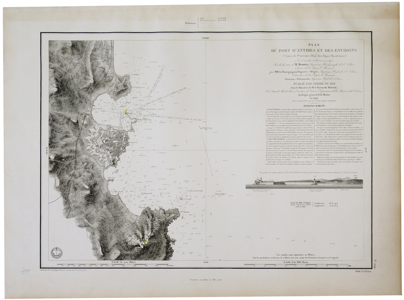
Dépôt Général de la Marine, 1843-1873. 470 x 591 mm.
Reference : LBW-5702
Belle carte marine figurant le port d'Antibes et ses environs, levée en 1840, dressée et publiée en 1843, puis mise au jour et publiée à nouveau en 1873. Le plan montre le Fort Carré, la ville d'Antibes avec l'usine à gaz, l'église Notre-Dame d'Antibes et le phare de la Garoupe. À gauche du plan figure une vue de la côte, prise en canot, et montrant le bastion des Cinq Cents Francs, le Grand Môle, la gare, la chapelle Saint-Roch et le château. Les feux et phares sont aquarellés en jaune avec un point rouge. Les profondeurs marines sont exprimées en mètres. Bel exemplaire.
Bookseller's contact details
Librairie Le Bail
Didier Le Bail
13 rue Frédéric Sauton
75005 Paris
France
33 01 43 29 72 59
Payment mode
Sale conditions
Conditions de vente conformes aux usages et aux règlements du Syndicat de la Librairie Ancienne et Moderne (SLAM) et de la Ligue Internationale de la Librairie Ancienne (LILA). Paiements acceptés : cartes bancaires, via un lien de paiement, chèques, virements Conditions of sale in accordance with the practices and regulations of the Syndicat de la Librairie Ancienne et Moderne (SLAM) and the International League of Antiquarian Booksellers (ILAB). Payments accepted: credit cards, via payment link, checks, and bank transfers.