 Write to the booksellers
OAKLEY (Edward).
[BREST] Plan des ports et château de Brest. A plan of the city, port, & fortifications of Brest and Recouvrance, with their environs, taken by the Kings engineer.
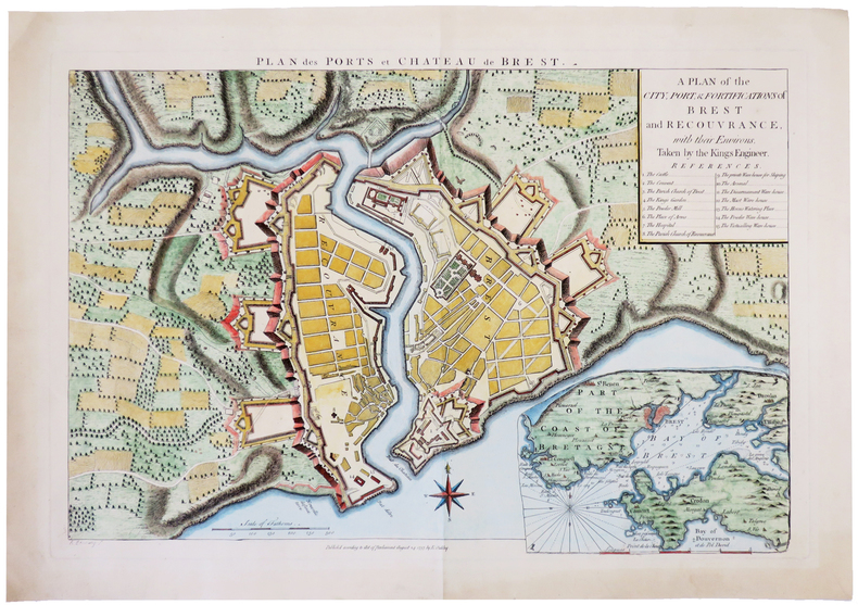
1757. 345 x 506 mm.
Reference : LBW-4984
Rare plan gravé figurant le port et le château de Brest, avec le quartier historique de Recouvrance, sur la rive droite de la Penfeld. Le plan a été dressé par Edward Oakley et gravé par Robert Benning. En bas à droite, en carton, figure une carte de la baie de Brest. Table de 15 légendes donnant les emplacements du château, du jardin du roi, de la place d'armes, de l'arsenal, etc. Bel exemplaire finement aquarellé à l'époque.
Bookseller's contact details
Librairie Le Bail
Didier Le Bail
13 rue Frédéric Sauton
75005 Paris
France
33 01 43 29 72 59
Payment mode
Sale conditions
Conditions de vente conformes aux usages et aux règlements du Syndicat de la Librairie Ancienne et Moderne (SLAM) et de la Ligue Internationale de la Librairie Ancienne (LILA). Paiements acceptés : cartes bancaires, via un lien de paiement, chèques, virements Conditions of sale in accordance with the practices and regulations of the Syndicat de la Librairie Ancienne et Moderne (SLAM) and the International League of Antiquarian Booksellers (ILAB). Payments accepted: credit cards, via payment link, checks, and bank transfers.