 Write to the booksellers
MOLL (Herman).
[SAINT KITTS] The Island of St. Christophers alias St. Kitts.
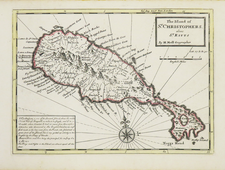
Londres, Thomas and John Bowles, [circa 1736]. 199 x 274 mm.
Reference : LBW-3534
Belle carte détaillée de l'île de Saint-Christophe ou Saint Kitts en anglais, issue de l'Atlas minor de Herman Moll, publié vers 1736. L'île est divisée en paroisses, et ornée d'une rose des vents. Au centre de l'île, on peut voir le volcan du Mount Misery, renommé Mount Liamuga lorsque l'île acquit son indépendance en 1983. Cartographe, graveur et éditeur d'origine hollandaise, ami du célèbre flibustier William Dampier, Herman Moll s'installa à Londres vers 1678, et devint dès le début du XVIIIe siècle l'un des plus éminents éditeurs de cartes et atlas londoniens. Bel exemplaire aux contours aquarellés à l'époque. Tooley, MCC n°81, Printed maps of St. Kitts, St. Lucia and St. Vincent, 20.
Bookseller's contact details
Librairie Le Bail
Didier Le Bail
13 rue Frédéric Sauton
75005 Paris
France
33 01 43 29 72 59
Payment mode
Sale conditions
Conditions de vente conformes aux usages et aux règlements du Syndicat de la Librairie Ancienne et Moderne (SLAM) et de la Ligue Internationale de la Librairie Ancienne (LILA). Paiements acceptés : cartes bancaires, via un lien de paiement, chèques, virements Conditions of sale in accordance with the practices and regulations of the Syndicat de la Librairie Ancienne et Moderne (SLAM) and the International League of Antiquarian Booksellers (ILAB). Payments accepted: credit cards, via payment link, checks, and bank transfers.