 Write to the booksellers
NEPTUNE FRANCOIS.
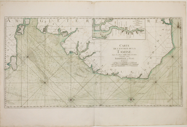
[TAMISE] Carte de l'entrée de la Tamise avec les bancs, passes, isles et costes comprises entre Sandwich et Clay.
[1693]. 454 x 895 mm.
Reference : LBW-2921
Superbe et grande carte marine figurant les côtes orientales de l'Angleterre entre Cley et Sandwich avec l'île de Thanet aujourd'hui rattachée au continent, issue de la première édition du Neptune François. Y figurent les lignes de rhumbs marquant la direction des vents, les profondeurs marines et deux roses des vents. Le nord est placé à gauche de la carte. En carton, carte détaillée du cours de la Tamise depuis l'île de Grain, orthographiée Greane, jusqu'à Londres, avec le nord placé au bas de la carte. Initié par Jean-Baptiste Colbert, ministre de Louis XIV et secrétaire d'État à la Marine, le Neptune François est le premier véritable atlas nautique publié en France et entièrement dédié à la Marine. La première édition a été publiée en 1693. Leurs auteurs sont deux membres de l'Académie Royale des Sciences, Joseph Sauveur, physicien et professeur de mathématiques au Collège de France, et Jean Mathieu de Chazelles, hydrographe de la Marine. Les huit cartes des côtes de la Bretagne, levées à partir de 1675 par Denis de la Voye, ingénieur ordinaire du Roi, forment la partie la plus précieuse du recueil. Très rare et bel exemplaire avec la mer entièrement aquarellée à l'époque. Rousseurs légères. Pastoureau, NEPTUNE FRANCAIS A, 8.
Bookseller's contact details
Librairie Le Bail
Didier Le Bail
13 rue Frédéric Sauton
75005 Paris
France
33 01 43 29 72 59
Payment mode
Sale conditions
Conditions de vente conformes aux usages et aux règlements du Syndicat de la Librairie Ancienne et Moderne (SLAM) et de la Ligue Internationale de la Librairie Ancienne (LILA). Paiements acceptés : cartes bancaires, via un lien de paiement, chèques, virements Conditions of sale in accordance with the practices and regulations of the Syndicat de la Librairie Ancienne et Moderne (SLAM) and the International League of Antiquarian Booksellers (ILAB). Payments accepted: credit cards, via payment link, checks, and bank transfers.
1 book(s) with the same title
"(JAILLOT, A.H.) - SEA-CHART OF THE ESTUARY OF THE THAMES FROM ""LE NEPTUNE FRANCOIS"".
Reference : 16120
(1693)
Carte de L'Entrée de la Tamise. Avec les Bancs, Passes, Isles et Costes comprises entre Sandwich et Clay. (No place, no date (1693)).
Large engraved seechart, measuring 46 x 89 cm. in original outline colouring. The chart showing the South-east coast of England from Sandwich to Clay. With inset view of The Thames between London and Greane Island. A fine impression on good thick paper with watermark: BYCOLUMBIER. Folded down the center.
The ""Neptune Francois"" was published in 1693, and its charts are larger and more lavishly decorated than those of any preceding book of its kind. This chart is without year, place and ""par Ordre du Roi"", pointing to a later issue, but issued from the original copperplate. It is also without ""Imprimerie Royale"" belonging to the imprints from 1792. Koeman IV,425:8.