 Write to the booksellers
NEPTUNE FRANCOIS.
[NORMANDIE/CALVADOS] I. Carte particulière des costes de Normandie depuis Dieppe jusqu'à la pointe de la Percée en Bessin.
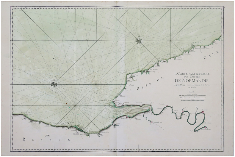
1693. 588 x 859 mm.
Reference : LBW-2886
Belle carte marine figurant les côtes normandes entre Vierville-sur-Mer et Dieppe, issue de la première édition du Neptune François. Y figurent les fonds marins, les lignes de rhumbs marquant la direction des vents et deux roses des vents. Initié par Jean-Baptiste Colbert, ministre de Louis XIV et secrétaire d'État à la Marine, le Neptune François est le premier véritable atlas nautique publié en France et entièrement dédié à la Marine. La première édition a été publiée en 1693. Leurs auteurs sont deux membres de l'Académie Royale des Sciences, Joseph Sauveur, physicien et professeur de mathématiques au Collège de France, et Jean Mathieu de Chazelles, hydrographe de la Marine. Les huit cartes des côtes de la Bretagne, levées à partir de 1675 par Denis de la Voye, ingénieur ordinaire du Roi, forment la partie la plus précieuse du recueil. Très rare et bel exemplaire avec la mer entièrement aquarellée à l'époque, et les villes principales aquarellées en rose. Légère trace de pliure verticale. Pastoureau, NEPTUNE FRANCAIS A, 16.
Bookseller's contact details
Librairie Le Bail
Didier Le Bail
13 rue Frédéric Sauton
75005 Paris
France
33 01 43 29 72 59
Payment mode
Sale conditions
Conditions de vente conformes aux usages et aux règlements du Syndicat de la Librairie Ancienne et Moderne (SLAM) et de la Ligue Internationale de la Librairie Ancienne (LILA). Paiements acceptés : cartes bancaires, via un lien de paiement, chèques, virements Conditions of sale in accordance with the practices and regulations of the Syndicat de la Librairie Ancienne et Moderne (SLAM) and the International League of Antiquarian Booksellers (ILAB). Payments accepted: credit cards, via payment link, checks, and bank transfers.