 Write to the booksellers
HONDIUS (Jodocus).
Tartaria.
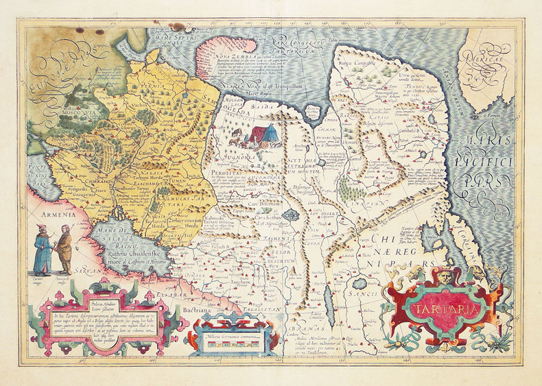
[1606-1608]. 341 x 496 mm.
Reference : LBW-2706
Superbe carte de la Tartarie ou partie de l'Asie septentrionale comprise entre la mer Noire et le Pacifique, avec le nord de la Chine et de l'Iran, la Corée et la côte nord-ouest de l'Amérique. La Corée est représentée comme une île, tandis que les côtes de la Nouvelle-Zemble, archipel de l'océan Arctique russe récemment exploré par Willem Barentsz entre 1594 et 1596, sont partiellement dessinées. Les continents asiatique et américain sont séparés par un imaginaire détroit d'Anian, nom donné au passage du Nord-ouest au XVIe siècle par les Espagnols, qui le croyaient à tort relier les deux continents. La carte est ornée d'un beau cartouche de titre, de deux personnages tartare et samoyède, et d'une vignette représentant une scène de camp au nord-ouest de la Sibérie. Texte latin au verso. Rousseurs dans la partie gauche de la carte, près du cadre ; mouillure claire dans la marge supérieure, petit manque de papier dans les marges gauche et droite. Exemplaire brillamment aquarellé à l'époque avec rehauts d'or. van der Krogt, 8050:1A.
Bookseller's contact details
Librairie Le Bail
Didier Le Bail
13 rue Frédéric Sauton
75005 Paris
France
33 01 43 29 72 59
Payment mode


5 book(s) with the same title
Reference : albf6da5070e9d4e19f
Kadykchansky Andrei. Small Encyclopedia of Big Tartaria. In 3 volumes. (set). In
Kadykchansky Andrei. Small Encyclopedia of Big Tartaria. In 3 volumes. (set). In Russian (ask us if in doubt)/Kadykchanskiy Andrey. Malaya entsiklopediya bolshoy Tartarii. V 3-kh tomakh. (komplekt). M. Belye alvy. 2018. 224 p. SKUalbf6da5070e9d4e19f.
Reference : alba0368722238d220e
Map of Tartaria and the Mandurah Empire. In Russian (ask us if in doubt)/Karta T
Map of Tartaria and the Mandurah Empire. In Russian (ask us if in doubt)/Karta Tartarii i Mandzhurskoy Imperii. Short description: In Russian (ask us if in doubt).Map of Siberia. Holland 1600. Luxury map, copper engraving, hand painted watercolor, two art cartouts from the way of life of Asian peoples. The map has Tyumen but no Tobolsk, there is the Ob River but no Yenisei River. The map was copied by hand by Semyon Ulyanovich Remizov, the builder of the Tobolsk Kremlin and publisher of the first atlas of Siberia (the Big Drawing Book of Siberia) at the end of the 17th century. We have thousands of titles and often several copies of each title may be available. Please feel free to contact us for a detailed description of the copies available. SKUalba0368722238d220e
Reference : alb35b1a73cf2e644f0
Brion Louis. Grand Tartaria and Japanese Islands Color engraved map of 1766 in
Brion Louis. Grand Tartaria and Japanese Islands Color engraved map of 1766 in the of Grande Tartarie et Isles de Japon engraver Louis Brion. In Russian (ask us if in doubt)/Brion Louis. Velikaya Tartariya i Yaponskie ostrova Tsvetnaya gravirovannaya karta 1766 goda v rame.Grande Tartarie et Isles de Japon Graver Louis Brion. Paris 1766. SKUalb35b1a73cf2e644f0.
Reference : bds-179b853b1adf8511
Siberia and part of Tartaria the Asian part of Russia: from the Volga to Kamcha
Siberia and part of Tartaria the Asian part of Russia: from the Volga to Kamchatka including the Volga region the Kyrgyz and Kalmyk steppes Bashkir Priamurye Astrakhan Tyumen Tobolsk Surgut Tomsk Izhevsk Krasnoyarsk Irkutsk Yakutsk Okhotsk Petropavlovsk Harbor Sakhalin Island the Kuril Islands compiled by D'Anvil. Vienna: published by F. A. Shremble 1787./Sibir' i chast' Tartarii Aziatskaya chast' Rossii: ot Volgi do Kamchatki v tom chisle Povolzh'e Kirgizskie i Kalmytskie stepi Bashkiriya Priamur'e Astrakhan' Tyumen' Tobol'sk Surgut Tomsk Izhevsk Krasnoyarsk Irkutsk Yakutsk Okhotsk Petropavlovskaya gavan' ostrov Sakhalin Kuril'skie ostrova sostavlena d'Anvilem. Vena: izdana F.A.Shremblom 1787. Short description: Dritter Theil der Karte von Asien welcher Sibirien und einige andere Theile der Tatarei en thalt. Verfast von Herrn d'Anville Verbessert herausgegeben von Herrn F.A.Shcraemb. MDCCLXXXVII. Zu finden in cigenem Verlage in Wien. Map of two sheets. Paper engraving on copper (etch ribbon) watercolor (border painting) Image size: 51 x 53 cm We have thousands of titles and often several copies of each title may be available. Please feel free to contact us for a detailed description of the copies available. SKUbds-179b853b1adf8511
Reference : alba1297d2af72756f9
Atlas of Tartaria. Eurasia on ancient maps. Myths. Images. Spaces. In Russian (a
Atlas of Tartaria. Eurasia on ancient maps. Myths. Images. Spaces. In Russian (ask us if in doubt)/Atlas Tartarii. Evraziya na starinnykh kartakh. Mify. Obrazy. Prostranstva.In History named after Sh. Mardjani of the Academy of Sciences of the Republic of Tatarstan. Kazan-M.: Publishing House of Feoria 2006 479s.. SKUalba1297d2af72756f9.