‎"C. A. Laisant"‎
‎"La Barbarie Moderne"‎

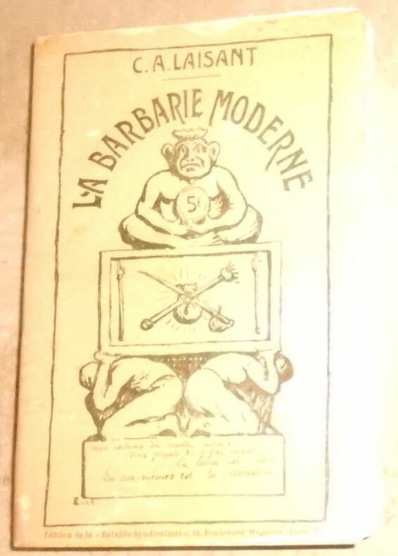
‎"1912. Paris Éditions de La Bataille Syndicaliste 1912 - Broché 13 cm x 19 5 cm 315 pages - Texte de C. A. Laisant index des noms cités - Couv. plastifiée sinon bon état" ‎

Reference : 18811


‎‎

€20.00 (€20.00 )
Bookseller's contact details

Librairie Sedon
M. Didier Sedon
62 rue Cochon Duvivier
17300 Rochefort
France

lechantdugallos2712@gmail.com

06 19 22 96 97

Contact bookseller

Payment mode
Cheque
Others
Sale conditions

Réglement par paypal, virement bancaire, chèque ou espèces.

Contact bookseller about this book

Enter these characters to validate your form.
*
Send

5 book(s) with the same title

‎[HISTOIRE] - LAISANT (C.A.)‎

Reference : 202201644

(1912)

‎La barbarie moderne. ‎

‎Paris, Éditions Bataille Sundicaliste, 1912 ; in-12, VIII-317 pp., broché. Tout sur les cruautés que les hommes s'infligent, mais aussi sur les cruautés politiques telles que les guerres, la police, la religion….‎


Phone number : 03 83 32 77 37

EUR30.00 (€30.00 )

‎LAISANT (C.-A.)‎

Reference : 941

(1912)

‎La barbarie moderne.‎

‎ 1912 Paris, Editions de la Bataille syndicaliste, 1912. In-12, 315 pages + table des matières. Reliure demi chagrin, dos à nerfs (muet). ‎


Musée du Livre - Chamalières

Phone number : 06 09 27 09 24

EUR37.00 (€37.00 )

‎LAISANT C.A:‎

Reference : 4863

(1912)

‎La barbarie moderne.‎

‎Paris, La Bataille Syndicaliste, 1912. In-8 broché de [6]-VIII-316-[4] pages, couverture illustrée. Dos frotté, traces de plis à la couverture, papier un peu jauni-. ‎


‎ Index des noms cités en fin. Une fois n'est pas coutume, les droits d'adaptation sont librement accordés à tous ! ‎

Phone number : +4122 310 20 50

CHF70.00 (€71.64 )

‎Laisant (Charles Ange)‎

Reference : 5219

‎La barbarie moderne‎

‎ édition de la bataille syndicaliste 10 boulevard Magenta Paris 1912 In12 broché 312 pages couverture illustrée par le militant libertaire Maximilien Luce - Bon état général‎


‎Charles Ange Laisant (1841-1920) militaire, mathématicien, boulangiste puis dreyfusard et anarchise à partir de 1893 ‎

Le Monde à l'Envers - Montargis

Phone number : 02 38 89 39 31

EUR60.00 (€60.00 )

‎CLOUET, J.B.L. [Jean, Baptiste, Louis. L'Abbe].‎

Reference : 1755

(1787)

‎Geographie Moderne: Barbarie/ Desert de Barbarie / Nigritie A hand coloured map of the Sahara desert & North Africa - Also showing Southern Europe‎

‎Paris: Mondhare et Jean, 1787 Une belle carte coloriée à la main, tirée de "Géographie moderne avec une introduction" de Clouet, son uvre la plus importante. La carte est centrée sur le désert du Sahara. La carte montre l'Espagne, l'Italie, la moitié de la France et « la Turquie en Europe ». Texte recto-verso (en français). Pliez au milieu de la carte, où lié dans sa géographie. Il n'y a pas de mention d'édition sur cette carte, mais elle correspond exactement aux 1787 pages de la Stanford University Collection. Verso vierge. La carte mesure 121/2" x 141/2" Le bloc gravé mesure 121/2" x 22" La feuille mesure 15" x 221/2" La carte est en bon état. Il y a une petite rousseur sur la carte, et elle a été coupée à un angle étrange, et un peu près du texte à la base de la carte (n'affectant pas le texte). Cela ne gâche pas le plaisir de la carte. Jean-Baptiste Louis Clouet (1729-1790) était un géographe français de l'Académie royale des sciences, né à Rouen. Son atlas général a été publié pour la première fois en 1767. Phillips enregistre 2 autres éditions de 1787 (Phillips No. 661) et 1791 (Phillips No. 673).‎


‎A lovely hand coloured map, taken from Clouet's "Geographie moderne avec une introduction," his most important work. The map is centred on the Sahara desert. The map shows Spain, Italy, half of France, and "Turkey in Europe." Text to both sides (in French). Fold to the middle of the map, where bound into his Geographie. There is no statement of edition on this map, but it conforms exactly to the 1787 pages in the Stanford University Collection. Verso blank. Map is 12<sup>1/2</sup>" x 14<sup>1/2</sup>" Engraved block is 12<sup>1/2</sup>" x 22" Sheet is 15" x 22<sup>1/2</sup>" The map is in good condition. There is a little foxing to the map, and it has been cut at a strange angle, and a little close to the text at the base of the map (not affecting text). It doesn't spoil the enjoyment of the map. Jean-Baptiste Louis Clouet (1729-1790) was a French geographer of the Royal Academy of Sciences, born in Rouen. His general atlas was first issued 1767. Phillips records 2 other editions from 1787 (Phillips No. 661) and 1791 (Phillips No. 673).‎

Logo ILAB

Phone number : +33 7 84 03 12 53

EUR99.00 (€99.00 )
Get it on Google Play Get it on AppStore
The item was added to your cart
You have just added :

-

There are/is 0 item(s) in your cart.
Total : €0.00
(without shipping fees)
What can I do with a user account ?

What can I do with a user account ?

  • All your searches are memorised in your history which allows you to find and redo anterior searches.
  • You may manage a list of your favourite, regular searches.
  • Your preferences (language, search parameters, etc.) are memorised.
  • You may send your search results on your e-mail address without having to fill in each time you need it.
  • Get in touch with booksellers, order books and see previous orders.
  • Publish Events related to books.

And much more that you will discover browsing Livre Rare Book !