 Write to the booksellers
-
Type
Art print (1)
Book (47749)
Engraving (83)
Magazine (223)
Manuscript (2)
Maps (116)
Music sheets (3)
Old papers (2)
-
Latest
Last 24h (1)
Last 3 days (4)
Last month (131)
Last week (42)
-
Language
Danish (1)
Dutch (1)
English (22)
French (48114)
German (26)
Italian (4)
Latin (3)
Portuguese (2)
Spanish (6)
-
Century
15th (1)
16th (11)
17th (66)
18th (462)
19th (5274)
20th (25316)
21st (2383)
-
Countries
Belgium (1351)
Brazil (2)
Canada (1)
China (4)
Côte d'Ivoire (31)
Denmark (268)
France (43596)
Greece (4)
Italy (794)
Switzerland (2128)
-
Syndicate
ALAC (1)
CLAQ (1)
ILAB (35966)
NVVA (1330)
SLACES (1330)
SLAM (33193)
SNCAO (14)
L AFRIQUE NOIRE OCCIDENTALE ET CENTRALE
EDSCO DOCUMENTS N°91. 1963. In-8. Broché. Bon état, Couv. convenable, Dos satisfaisant, Intérieur frais. 32 pages illustrées de quelques dessins en noir et blanc .. . . . Classification Dewey : 900-GEOGRAPHIE, HISTOIRE, SCIENCES AUXILIAIRES DE L'HISTOIRE
Classification Dewey : 900-GEOGRAPHIE, HISTOIRE, SCIENCES AUXILIAIRES DE L'HISTOIRE
LA FRANCE ET L'UNION FRANCAISE. GEOGRAPHIE . COURS MOYEN DES ECOLES PRIMAIRES
FERNAND NATHAN. NON DATE. In-4. Broché. Etat d'usage, Couv. légèrement pliée, Dos frotté, Intérieur acceptable. 64 pages. Premier plat illustré en couleurs. Nombreuses illustrations en couleurs et noir et blanc dans et hors texte. Ouvrage légèrement déboité.. . . . Classification Dewey : 372.89-Livre scolaire : histoire / géographie
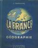
Classification Dewey : 372.89-Livre scolaire : histoire / géographie
LA FRANCE ET L'UNION FRANCAISE, GEOGRAPHIE, COURS MOYEN DES ECOLES PRIMAIRES
Nathan. Non daté. In-4. Cartonné. Etat passable, Plats abîmés, Dos abîmé, Intérieur acceptable. 63 pages. Illustré de nombreux dessins et de nombreuses photos et cartes en noir et blanc et en couleur, dans le texte. Texte sur 2 colonnes. Manques sur le dos. Quelques taches d'encre et annotations dans l'ouvrage (ouvrage de travail).. . . . Classification Dewey : 372.89-Livre scolaire : histoire / géographie
Cartes établies par L. BERGELIN. Classification Dewey : 372.89-Livre scolaire : histoire / géographie
LA TERRE, LES GRANDES PUISSANCES. GEOGRAPHIE. CLASSE DE FIN D'ETUDES, CERTIFICAT D'ETUDES PRIMAIRES
FERNAND NATHAN. NON DATE. In-4. Broché. Etat d'usage, Couv. légèrement passée, Dos satisfaisant, Intérieur frais. 32 pages. Premier plat illustré en couleurs. Nombreuses illustrations en couleurs et noir et blanc dans et hors texte.. . . . Classification Dewey : 372.89-Livre scolaire : histoire / géographie
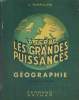
Classification Dewey : 372.89-Livre scolaire : histoire / géographie
LA NOUVELLE GEOGRAPHIE AU COURS MOYEN. LA FRANCE ET L'UNION FRANCAISE.
FERNAND NATHAN. 1954. In-4. Cartonné. Etat d'usage, Couv. légèrement passée, Dos satisfaisant, Intérieur frais. 64 pages. Premier plat illustré en couleurs. Nombreuses illustrations en couleurs et noir et blanc dans et hors texte.. . . . Classification Dewey : 372.89-Livre scolaire : histoire / géographie
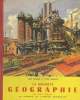
Classification Dewey : 372.89-Livre scolaire : histoire / géographie
FRANCE 360°.
CHENE. 2008. In-8. Relié. Bon état, Couv. convenable, Dos satisfaisant, Intérieur frais. environ 100 pages - nombreuses photographies en couleurs dans et hors texte - nombreuses pages à déplier - ouvrage en français et en anglais.. . . A l'italienne. Classification Dewey : 900-GEOGRAPHIE, HISTOIRE, SCIENCES AUXILIAIRES DE L'HISTOIRE
Photographies de Franck Charel - Ouvrage en français et en anglais. Classification Dewey : 900-GEOGRAPHIE, HISTOIRE, SCIENCES AUXILIAIRES DE L'HISTOIRE
JUIFS MES FRERES
GUY VICTOR. 1963. In-4. Broché. Bon état, Couv. convenable, Dos satisfaisant, Intérieur frais. 270 pages illustratrées de photos hors texte.. . . . Classification Dewey : 900-GEOGRAPHIE, HISTOIRE, SCIENCES AUXILIAIRES DE L'HISTOIRE
Préface de Cardinal Gerlier. Classification Dewey : 900-GEOGRAPHIE, HISTOIRE, SCIENCES AUXILIAIRES DE L'HISTOIRE
NAPOLEON LE SACRE
IMPRIMERIE NATIONALE EDITION. 1993. In-8. Broché. Bon état, Couv. convenable, Dos satisfaisant, Intérieur frais. 134 pages. Couverture rempliée.. . . . Classification Dewey : 900-GEOGRAPHIE, HISTOIRE, SCIENCES AUXILIAIRES DE L'HISTOIRE
Acteurs de l'histoire. Classification Dewey : 900-GEOGRAPHIE, HISTOIRE, SCIENCES AUXILIAIRES DE L'HISTOIRE
VILLES DE PROVENCE ET COTE D'AZUR
EDITIONS DU SUD ET ALBIN MICHEL. 1966. In-8. Cartonné. Bon état, Couv. convenable, Dos satisfaisant, Intérieur frais. 277 pages. Quelques planches en noir et blanc.. . . . Classification Dewey : 900-GEOGRAPHIE, HISTOIRE, SCIENCES AUXILIAIRES DE L'HISTOIRE
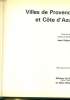
"""Hommes et cités"" Classification Dewey : 900-GEOGRAPHIE, HISTOIRE, SCIENCES AUXILIAIRES DE L'HISTOIRE"
L'EUROPE DANUBIENNE ET BALKANIQUE 1867-1970. HISTOIRE 1er CYCLE.
MASSON ET Cie / UN SIECLE D'HISTOIRE. 1973. In-8. Broché. Etat d'usage, Couv. légèrement passée, Dos plié, Intérieur frais. 194 pages. Cartes en noir et blanc ou noir et une couleur dans le texte.. . . . Classification Dewey : 372.89-Livre scolaire : histoire / géographie
Classification Dewey : 372.89-Livre scolaire : histoire / géographie
L'EGLISE ET LE CAPITALISME, QUESTIONS POSEES AUX CATHOLIQUES.
PRIVAT. 1959. In-12. Broché. Etat d'usage, Couv. légèrement passée, Dos satisfaisant, Non coupé. 134 pages. Premier plat illustré en noir et blanc.. . . . Classification Dewey : 270-Histoire et géographie de l'Eglise
Classification Dewey : 270-Histoire et géographie de l'Eglise
LES CHATEAUX DE L ILE DE FRANCE
CHEZ L AUTEUR. 1937. In-Folio. Cartonnage d'éditeurs. Bon état, Couv. convenable, Dos satisfaisant, Intérieur frais. 33 planches et 11 textes.. . . . Classification Dewey : 900-GEOGRAPHIE, HISTOIRE, SCIENCES AUXILIAIRES DE L'HISTOIRE
Classification Dewey : 900-GEOGRAPHIE, HISTOIRE, SCIENCES AUXILIAIRES DE L'HISTOIRE
UNE TRADITION SCOLAIRE OUBLIEE, LE LIVRE DE PRIX. 120 LIVRES DE PRIX DE 1754 A 1939. AMIS DE SAINTE FOY ET SA REGION
AU BUREAU DU JOURNAL. 1er trimestre 1986. In-4. Broché. Bon état, Couv. convenable, Dos satisfaisant, Intérieur frais. 34 pages + Une lettre de l'auteur.. . . . Classification Dewey : 900-GEOGRAPHIE, HISTOIRE, SCIENCES AUXILIAIRES DE L'HISTOIRE
Classification Dewey : 900-GEOGRAPHIE, HISTOIRE, SCIENCES AUXILIAIRES DE L'HISTOIRE
"Nouvelle Géographie Générale de la France l'Algérie et les Colonies Françaises - II"
"Paris. 19 cm x 28 5 cm. Cartonné. 1202 pages. Paris Éditions Garnier Frères s.d. (circa 1900). Cartonné percaline rouge tranches dorées 19 cm x 28 5 cm 1202 pages illustrations et photographies noir et blanc in-texte et cartes hors-texte. Textes de Jean Wahl et Henri Vast. Couverture en état moyen bon état intérieur. On trouve dans cet ouvrage les départements de Bretagne de Normandie du Perche Maine et d'Ile de France plus l'Algérie et les colonies les trois quart du livre leurs étant consacré" "Etat correct"
LES RICHESSES DE FRANCE - EURE NORMANDIE
EDL. 1992. In-4. Cartonnage d'éditeurs. Bon état, Couv. convenable, Dos satisfaisant, Intérieur frais. 96 pages. Nombreuses photos en couleurs, dans le texte et hors texte.. Avec Jaquette. . . Classification Dewey : 900-GEOGRAPHIE, HISTOIRE, SCIENCES AUXILIAIRES DE L'HISTOIRE
Classification Dewey : 900-GEOGRAPHIE, HISTOIRE, SCIENCES AUXILIAIRES DE L'HISTOIRE
Villes de France - Cartes, plans et vues historiques
Assouline 2007 In-folio reliure éd. sous jaquette 40,4 cm sur 30,4. 174 pages. Jaquette en mauvais état. Bon état d’occasion.
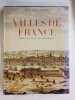
Bon état d’occasion
Atlas des Indes Occidentales, ou Description Géo-Hydrographique des Régions, des Côtes, des Isles, & des Mers, connues sous le nom d'Indes Occidentales, dans laquelle On trouve réunis tous les Détails Géographiques & Nautiques qui appartiennent à c... - [THE WEST-INDIES]
London, Robert Sayer & Jean Bennett, 1777. [Engraved title: London, Sayer & Bennett, 1775]. Folio. Recently bound in a magnificent pastiche-binding of brown half calf with six raised bands and gilt red leather title-label to elaborately gilt spine. Vellum corners and lovely marbled paper over boards. The binding is made over the original one, preserving the original sewn spine underneath as well as the original end-papers. An excellent, beautiful copy. Very clean and fresh. Only minor, light browning to a few maps, and last map with a bit more staining. One map with a small tear to lower margin, far from effecting engraving. Previously in the possession the Danish medieval estate Ravnholt, since the 18th century owned by the noble family of Sehestedt Juul, with discreet stamps from this ownership to title-page: ""Sehestedt Juel"" and ""Rauenholdts Bibliothek"". Title-page (French) + 6 pp. of preface (French) + (2) pp. of index (French) + double-page engraved, illustrated title (English) + 36 double-page and 3 single-page engraved maps, all (but one) dated London, Sayer, 1775 (one map - Antigua - without the year, but London, Sayer).
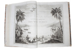
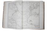
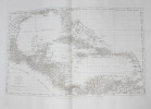
Scarce first French edition - consisting in all the original 39 maps of the 1775 English edition (all (but Antigua) dated 1775) and the engraved double title-page in English, preceded by a French title, preliminary discourse (also in French), and index - of Jeffery's seminal West-India atlas, one of the most important works on the West Indies and the work that we have to thank for the introduction of ""Carribean"" as the designation that was to become standard on maps. The work played a pivotal rôle in the geo- and cartographical denomination of places and areas in this part of the world. In his preface, Jefferys does away with previous terms applied by geographers: ""La division des Espagnols, & elle se trouve tout-à la fois physique & politique, fut adoptée bientôt par les Anglois, les Hollandois & queslques autres peuples"" la plûpart des navigateurs & des marchands en s'y conformant, ont imposé depuis longtemps à tous les Géographes la nécessité de diviser l'Amerique en trois parties, savoir, ""Amerique du Nord"", ""Indes Occidentales"", ""Amerique du Sud."" Mais les Géographes, surtout les Francois, ont perséveré dans leur ancienne division, probablement parce qu'ils aiment à se répéter, & souvent aussi à se copier l'un l'autre."" (From the preface, p.2). (i.e.: ""The division of the Spanish, and this is found in both physics & polics, was soon adopted by the English, the Dutch & some other populations"" the main part of navigators and merchants have complyed herewith and have long made clear to geographers the necessity to divide America into three parts, namely, ""North America"", ""West Indies"", ""South America."" But geographers, especially the French, have persevered in their old division, probably because they like to repeat, and often also to copy, one another"").But not only does Jefferys extend this denominal division of America to geographers and cartographers, he also (re-)introduces the designation that was to become standard of the Caribbean: ""Les premier Espagnols l'appellèrent Mer du Nord lorsqu'ils eurent découvert une nouvelle mer au delà de l'isthme de Panama. Quelquefois on lui a donné le nom de ""Mer Caribe"" ou ""Caribenne"", qu'il auroit mieux volu adopter que de laisser anonyme un aussi vaste espace."" (From the preface, p. 2, 1).- ""Although the best-known sea of the New World, the Caribbean remained nameless longest. It was the original Mar del Norte, a term promptly extended to all parts of the western atlantic. Velasco tried to find a proper name for it, saying: ""de los Canibales llaman el golfo grande del mar Océano desde de Deseada y Dominica por toda la costa de Tierra Firme, Yucatán, Golfo de Tierra Firme y de las islas del mar del Norte."" This compiler in Spain, regarding the maps before him, made the distinction we do between Caribbean Sea and Gulf of Mexico. (Gulf of Tierra Firme was that of Darién.) Velasco remained in manuscript until the nineteenth century, and I do not know that his Gulf of the Cannibals was ever thus known. In the introduction to his ""West Indian Atlas"", Thomas Jefferys wrote, two centuries later: ""It has been sometimes called the Caribbean-Sea, which name it would be better to adopt, than to leave this space quite anonymous"""" he did so on his map. North European nations at the time were in possession of the Carib islands (the Lesser Antilles) and it is perhaps thus that Jefferys introduced the designation that was to become standard on maps but was not adopted in Spanish lands."" (C.O. Sauer, ""The Early Spanish Main"", p. 2). As one of the earliest documentations of the West Indies, Jefferys' seminal ""West-India Atlas"" was informed by prevailing attitudes about the legitimacy of Britain's colonial enterprises and contemporary debates surrounding the abolition and emancipation movements and played a significant rôle in the spreading of knowledge regarding this part of the world. Jefferys himself, one of the most prominent and prolific map publishers and engravers of his day, was opposed to the slave-trade, which unfortunately hinged upon the sugar trade that the atlas was designed to aid, and also spoke out against it. The English cartographer Thomas Jefferys (c. 1719-1771), ""Royal Geographer to King George III"" was the leading map supplier of his day and as such had access to information that many other cartographers did not. He engraved and printed maps for government and other official bodies and produced a wide range of commercial maps and atlases, most famously of America and the West Indies.Having died in 1771, he did not live to see the publication of his great ""West India Atlas"", which was published by Robert Sayer, who, in partnership with John Bennett, had acquired his maps. Thus, the West India Atlas was published posthumously, under Jefferys' name. Philips III:p. 570.
Diagramme N° 149 - Les richesse de l'océan
Editons du cap Monte-Carlo. Juillet 1969. In-12. Broché. Bon état, Couv. convenable, Dos satisfaisant, Intérieur frais. 95 pages environ illustrées de nombreuses photos et dessins noir et blanc.. . . . Classification Dewey : 900-GEOGRAPHIE, HISTOIRE, SCIENCES AUXILIAIRES DE L'HISTOIRE
Classification Dewey : 900-GEOGRAPHIE, HISTOIRE, SCIENCES AUXILIAIRES DE L'HISTOIRE
L'ENJEU DU RENOUVEAU CHARISMATIQUE ?
"FAYARD / LE SARMENT. VERS 1988. In-8. Broché. Bon état, Couv. convenable, Dos satisfaisant, Intérieur frais. 150 pages. Collection ""Des chrétiens"". . . . Classification Dewey : 270-Histoire et géographie de l'Eglise"
Classification Dewey : 270-Histoire et géographie de l'Eglise
Questions d'histoire Education et cultures dans l'Occident chrétien Début du XIIe siècle - Milieu du XVe
Du temps. 1998. In-8. Broché. Bon état, Couv. convenable, Dos satisfaisant, Intérieur frais. 255 pages.. . . . Classification Dewey : 372.89-Livre scolaire : histoire / géographie
CAPES & Agrégation ,d'histoire et géographie Classification Dewey : 372.89-Livre scolaire : histoire / géographie
LE GRAND RETOUR.
ALBIN MICHEL. 1977.. In-8. Broché. Bon état, Couv. convenable, Dos satisfaisant, Intérieur frais. 348 pages. 1ère de couverture illustrée en couleurs.. . . . Classification Dewey : 900-GEOGRAPHIE, HISTOIRE, SCIENCES AUXILIAIRES DE L'HISTOIRE

Collection H comme histoire dirigée par Philippe Bourdrel. Préface de Golda Meir. Classification Dewey : 900-GEOGRAPHIE, HISTOIRE, SCIENCES AUXILIAIRES DE L'HISTOIRE
L'Occident des dissidents
Stock 1979 in8. 1979. Broché.


Bon Etat couverture jaunie intérieur propre
ENCYCLOPEDIE ILLUSTREE DE L'HOMME PREHISTORIQUE
GRUND Collection Encyclopédies. 1978. In-8. Relié. Etat d'usage, Couv. défraîchie, Dos satisfaisant, Intérieur frais. 559 pages. Nombreuses illustrations couleur et noir et blanc.. . . . Classification Dewey : 900-GEOGRAPHIE, HISTOIRE, SCIENCES AUXILIAIRES DE L'HISTOIRE
Classification Dewey : 900-GEOGRAPHIE, HISTOIRE, SCIENCES AUXILIAIRES DE L'HISTOIRE
"L'Eglise et l'Etat en Italie de Risorgimento à nos jours (Collection ""Esprit"")"
Seuil. 1960. In-8. Broché. Etat d'usage, Couv. défraîchie, Dos satisfaisant, Papier jauni. 283 pages. Intérieur non coupé. Rousseurs.. . . . Classification Dewey : 270-Histoire et géographie de l'Eglise
Traduit de l'italien par Madeleine et Robert Juffé. Préface de Robert Juffé. Classification Dewey : 270-Histoire et géographie de l'Eglise
VOYAGE MALTE
EDITIONS MONDEOS. 2006. In-12. Broché. Bon état, Couv. convenable, Dos satisfaisant, Intérieur frais. 108 pages. Nombreuses illustrations en couleur, dans le texte et hors texte.. . . . Classification Dewey : 910-Géographie générale. Voyages
Classification Dewey : 910-Géographie générale. Voyages