 Write to the booksellers
-
Type
Artists book (1)
Book (8424)
Engraving (3)
Magazine (10)
Maps (356)
-
Latest
Last 24h (1)
Last month (98)
Last week (14)
-
Language
Bulgarian (1)
English (1)
French (8774)
German (10)
Italian (1)
Polish (1)
Portuguese (1)
Russian (1)
Spanish (4)
-
Century
16th (8)
17th (22)
18th (196)
19th (1472)
20th (2890)
21st (434)
-
Countries
Belgium (136)
Brazil (1)
Canada (3)
China (26)
Côte d'Ivoire (1)
Denmark (39)
France (8364)
Greece (1)
Netherlands (2)
Switzerland (220)
United States of America (1)
-
Syndicate
ALAC (3)
CLAQ (2)
CNE (1)
ILAB (6986)
NVVA (127)
SLACES (127)
SLAM (6802)
SNCAO (2)
30 cartes des Environs de Paris. Est.-
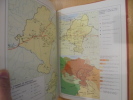
Paris. Hachette. Sans date. Petit in-4 (206 x 204 mm) cartonnage dos toile bleue de l'éditeur, 32 cartes en couleurs, accompagnées de commentaires en vis à vis illustrés de photos formant un dictionnaire des communes. Tableau d'assemblage en frontispice. Petits défauts d'usage mais bon exemplaire.
30 cartes des Environs de Paris. Ouest.-
Paris. Hachette. Sans date. Petit in-4 (206 x 204 mm) cartonnage dos toile bleue de l'éditeur, 32 cartes en couleurs, accompagnées de commentaires en vis à vis illustrés de photos formant un dictionnaire des communes. Tableau d'assemblage en frontispice. Petits défauts d'usage mais bon exemplaire.
Cartes generale et particulieres de toutes les costes de France, tant de la mer Oceane que Mediterranee
Paris, Michel Vanlochom 1634 In-4 à l’italienne 26,5 x 39 cm. Reliure plein vélin souple de l’époque, titre manuscrit, 2 ff.- 14 pp. & 32 planches dont 2 de titre gravé, une carte générale repliée restauration sans manque et 29 cartes particulières une infime restauration. Texte sur deux colonnes latin et français en regard. Marges brunies. Humidité marginale éparse. Ex-libris Prosper Falgairolle. Bon exemplaire.
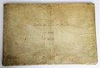
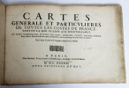
Une des deux éditions publiées la même année. Les 29 cartes visaient à faciliter la défense côtière au plus fort de la Guerre de Trente ans. La première partie trace la côte atlantique de Calais à San Sebastian, la seconde la côte méditerranéenne de la frontière espagnole à Villefranche. Dans les années 1630, Christophe Tassin, commissaire ordinaire des guerres et géographe du roi, fit passer les sources militaires dans la cartographie civile, qu’il renouvelle, alors que les cartes générales sont encore marquées par l’oeuvre de La Guillotière. Bon état d’occasion
The Sea-Coasts of France, from Calais to Bayone. Described in Fifteen Large Charts. Surveyed and Printed by the order of the French King. From the Original, done at Paris, and the Remarks Explained in English, and Published for the Use of His Majesty'...
London, Printed for William Mount and Thomas Page on Tower Hall, no date (c. 1715). Folio. 53X35 cm. Cont. hcalf with marbled boards. Rebacked and recornered in old style with raised bands. Engraved typographical titlepage with a large engraved vignette showing the English King's Coat of Arms. With all 15 double-page engraved sea-charts (numbered (1)-(15) in lower right corners). Neat repairs to inner margins of free endpapers and titlepage. Some browning to charts. Chart 5 (45x75,5 cm) having the right margin shaved reaching the printed frame.
Second edition of this scarce ""Atlas Maritime"". According to Shirley it was first published by Richard Mount and Thomas Page in 1701 and re-issued with undated title (as this) in ab. 1715, but with the charts unchanged and a new engraved titlepage. A third issue came out in 1737 with a dated title. The fine charts are copied from Pieter Mortier's famous ""Neptune Francois"" (1693-1702) and reduzed in size.""The charts in this early Mount & Page atlas ""The Sea-Coasts of France"" are re-engravings, reduzed in size, from the charts in the French Neptune of 1693. The charts may also be found in the 1702 edition of Mount and Page's Atlas Maritimus Novus..."" (Rodney Shirley). - Not in Phillips. - Shirley Vol. II: M.M&P - 12 b.
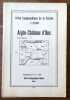
Aigle - Château d'Oex.
Berne, Service topographique fédéral, 1934. Carte au 1:25.000, au format ouvert de 94 x 78 cm.
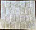
FLEURIER N°280
SERVICE TOPOGRAPHIQUE FEDERAL. Non daté. In-Folio. Broché. Etat d'usage, Couv. légèrement passée, Dos satisfaisant, Intérieur acceptable. Carte dépliante en 8 volets au 1/25.000e en couleurs.. . . . Classification Dewey : 912-Atlas, cartes et plans
Classification Dewey : 912-Atlas, cartes et plans
LA COTE AUX FEES FEUILLE N°282
SERVICE TOPOGRAPHIQUE FEDERAL. Non daté. In-Folio. Broché. Etat d'usage, Couv. légèrement passée, Dos satisfaisant, Intérieur acceptable. Carte dépliante en 8 volets au 1/25.000e en couleurs.. . . . Classification Dewey : 912-Atlas, cartes et plans
Classification Dewey : 912-Atlas, cartes et plans
MAUBORGET FEUILLE N°284
SERVICE TOPOGRAPHIQUE FEDERAL. Non daté. In-Folio. Broché. Etat d'usage, Couv. convenable, Dos satisfaisant, Intérieur acceptable. Carte dépliante en 8 volets au 1/25.000e en couleurs.. . . . Classification Dewey : 912-Atlas, cartes et plans
Classification Dewey : 912-Atlas, cartes et plans
Ste - CROIX FEUILLER N°283
SERVICE TOPOGRAPHIQUE FEDERAL. Non daté. In-Folio. Broché. Etat d'usage, Couv. convenable, Dos satisfaisant, Intérieur acceptable. Carte dépliante en 8 volets au 1/25.000e en couleurs.. . . . Classification Dewey : 912-Atlas, cartes et plans
Classification Dewey : 912-Atlas, cartes et plans
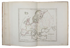
Nouvel atlas classique physique, politique, historique et commercial divisé en trois parties.
Paris, A alexandre libraire, s.d. ; in-8 oblong, 70 pp., demi cuir frotté.
.
La France et ses colonies. Atlas illustré. Cent cartes dressées d'après les cartes de Cassini, du Dépôt de la guerre, des Ponts-et-Chaussées et de la Marine.
Paris-Montrouge, J. Migeon, 1869, gr. in-4° (26 x 35,5), 238 pp, texte sur deux colonnes avec encadrement typographique, 100 cartes hors texte réhaussées en couleurs et ornementées de vignettes en noir, dont certaines cartes à double page montées sur onglets (dont 3 cartes de l'Algérie : provinces d'Alger, de Constantine, d'Oran) et 3 cartes grand format dépliantes (France physique, administrative et routière, Plan de Paris, Chemins de fer et lignes télégraphiques de la France), reliure pleine percaline noire de l'éditeur, dos lisse à caissons à froid et titres dorés, encadrements à froid sur les plats, titre doré au 1er plat et décor doré au second plat, bon état
Texte rédigé d'après les documents officiels et sur un plan entièrement nouveau réunissant en forme de tableaux : 1) La division administrative, politique, judiciaire, religieuse, militaire etc. ; 2) Les Vicissitudes historiques ; 3) La Biographie ; 4) La Statistique ; 5) Les Ressources agricoles, industrielles, commerciales ; 6) Les Etablissements d'instruction ou d'utilité publique ; 7) La Description détaillée de tous les chefs-lieux d'arrondissement et des lieux remarquables ; 8) Enfin les Curiosités et la Physionomie morale de chaque département et de chaque colonie française. Désormais les frais d'envoi sont de 6 € seulement pour les livres jusqu'à 1 kg (colissimo suivi), pour la France métropolitaine.
Atlas Géographique du Journal La France Administrative.-
Paris. Georges Hurtrel. Vers 1870. 1 volume in-f° à l'italienne (356 x 263 mm) cartonnage rouge de l'éditeur, titre doré sur le 1er plat, Contient: Mappemonde, Afrique, Amérique, Asie, Europe, Océanie, France, 89 départements, Algérie Isthme de Suez, Colonies françaises et 2 grandes lithographies à 2 teintes de Fichot: Paris et Rome. Complet. Cartes en noir et blanc, chacune entourée d'un même décor évoquant les cinq parties du monde. Mors intérieur du 1er plat faible, Cartonnage un peu fané, très bon état intérieur malgré de tout petits défauts. Rare.
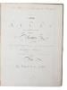
ATLAS DES ENFANS ou nouvelle méthode pour apprendre la Géographie avec un nouveau traité de la Sphere et XXIV cartes enluminées
Lyon Chez Jean-Marie Bruyset, Père é Fils 1784 in 12 (17x10) 1 volume reliure pleine basane fauve de l'époque, dos à nerfs orné, caissons dorés, pièce de titre de cuir beige, dos lisse, tranches teintées bleu, frontispice gravé, XI et 331 pages, avec 24 cartes gravées enluminées. Bel exemplaire
Très bon Couverture rigide
A New Atlas Or a Compleat Set of Maps. Representing the different Empires, Kingdoms, States of the known World Including the Modern Discoveries by J. Young, A.M.
(Edinburgh and London ?), (1778). Large 4to. (32 x 24,5 cm.). Contemp. hcalf. Raised bands. Title-label with gilt lettering. Top of spine lacks ca. 1 cm. of leather, bottom of spine ca. 1/2 cm. Spine rubbed, wear along hinges. Old owner inscription on top of title-page. Ex Libris Scholae Regis Edinensis. Engraved title-page and 23 double-page (numb. 1-23) and all with original handcolouring. The map of the world (2 hemispheres): printed size 25 x 46 cm. (sheet: 31 x 48,5 cm.). Printed on heavy paper, verso blank, all clean and fine.
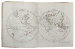
First edition. Not in Shirley. The copy described by Shirley I, T.YOU - 1 a, having another imprint dated 1782. All the maps in our copy is signed ""Published as the Act directs 1st July 1778"". Shirley mentions that the Atlas was doubtless intended for educational use.
Nouvel atlas d'entomologie, n°9 : Atlas des coléoptères de France, Fascicule 1 : Carabes, staphylins, dytiques, scarabées
Editions N. Boubée & Cie Nouvel Atlas d'Entomologie Broché 1959 In-12 (13,5 x 18,5 cm), broché, 83 pages, planches en couleur ; dos et bords des plats brunis, tache au premier plat, quelques annotations au crayon à l'intérieur, assez bon état. Livraison a domicile (La Poste) ou en Mondial Relay sur simple demande.
Atlas des cités perdues
Arthaud Sans date. Cet atlas explore le destin de plus de quarante cités aujourd'hui disparues illustrant la mortalité des villes et des civilisations à travers des récits inattendus mais bien réels
ATLAS: Annales des sciences naturelles Année 1827.
Annales des sciences naturelles par MM AUDOIN- BRONGNIART Ad et DUMAS. Année 1827. Atlas des tomes 10-11-12 Comprenant 54 planches Paris CROCHARD libraire éditeur. In 4 carré demi-chagrin vert, titre, filets, tomaison, dorés. Faux-titre, titre, 24 pages, à la suite 54 planches, certaines dépliantes, certaines en couleurs. Bon exemplaire. Anatomie et physiologie animale, sociologie, anatomie et physiologie végétale, botanique, minéralogie, géologie.

1 CARTE MARITIME EN NOIR ET BLANC - OCEAN ATLANTIQUE - AFRIQUE EQUATORIALE FRACAISE - PORT GENTIL - CARTE N°5885
***. 1955. In-Plano. En feuillets. Bon état, Couv. convenable, Dos satisfaisant, Intérieur frais. 1 carte en noir et blanc de 53 x 74 cm. Echelle1 /30000.. . . . Classification Dewey : 912-Atlas, cartes et plans
Classification Dewey : 912-Atlas, cartes et plans
ATLAS PREPARATOIRE - 90 GRAVURES - 20 CARTES - 14 TABLEAUX - 90 gravures - 20 cartes - 14 drapeaux
LIBRAIRIE LAROUSSE. NON DATE. In-8. Relié. Etat d'usage, Couv. défraîchie, Dos satisfaisant, Intérieur acceptable. 31 pages augmentées de nombreuses illustrations en noir et blanc et de cartes en couleur dans et hors texte. Coins émoussés. Tampon sur la premier plat et sur la 1ière page.. . . . Classification Dewey : 912-Atlas, cartes et plans
Classification Dewey : 912-Atlas, cartes et plans
ATLAS PREPARATOIRE - LECONS - LECTURES - QUESTIONNAIRES ET DEVOIRS - EXERCICES D'ELOCUTION
LAROUSSE. VERS 1916. In-8. Cartonné. Etat d'usage, Tâchée, Dos satisfaisant, Quelques rousseurs. 32 Pages. Nombreuses gravures et cartes en couleur et en noir et blanc dans et hors texte. Quelques rousseurs sans conséquence pour la lecture. Annotation au stylo sur le 1er contre plat.. . . . Classification Dewey : 912-Atlas, cartes et plans
Classification Dewey : 912-Atlas, cartes et plans
Atlas des champignons avec 460 illustrations en couleurs et en noir
Fernand Nathan 1981 327 pages in4. 1981. cartonnage editeur avec jaquette. 327 pages. Atlas des champignons est un ouvrage de référence publié en 1973 par Fernand Nathan écrit par Augusto Rinaldi et Vassili Tyndalo. Il présente plus de 1000 espèces ou variétés de champignons européens américains et asiatiques avec 460 illustrations en noir et blanc et en couleurs. Le livre aborde l'habitat la culture la cueillette et la conservation des champignons
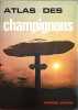
Bon état jaquette usagée très bon état intérieur
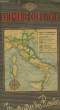
AUTO STRADE IN ITALIA
CHEZ L'AUTEUR. 1968. In-4. Cartonné. Bon état, Couv. convenable, Dos satisfaisant, Intérieur frais. 18 pages en couleurs, hors texte + environ 6 pages.. . . . Classification Dewey : 912-Atlas, cartes et plans
Classification Dewey : 912-Atlas, cartes et plans
Itinéraires des Routes
CHEZ L'AUTEUR. Non daté. In-4. En feuillets. Etat d'usage, Couv. défraîchie, Dos satisfaisant, Intérieur frais. Environ 100 planches de cartes et plans en couleurs, dans le texte. Couverture rempliée. Petites déchirures sur les plats.. . . . Classification Dewey : 912-Atlas, cartes et plans
Echelle 1/300000 Classification Dewey : 912-Atlas, cartes et plans
XVII Olimpiade. Roma 1960. Routes, itinéraires
E.N.I.T.. 1960. In-12. Broché. Bon état, Couv. convenable, Dos satisfaisant, Intérieur frais. Dépliant en couleurs : 6 cartes des routes italiennes - Un plan de Rome et un plan des routes au départ de Rome. . . . Classification Dewey : 912-Atlas, cartes et plans
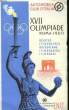
Classification Dewey : 912-Atlas, cartes et plans
ATLAS DE NAVARRA. GEOGRAFICO-ECONOMICO-HISTORICO.
Diáfora. Barcelona. 1977. 79 pp. Folio menor (30 cm) Encuadernado cartoné.
Buen estado general. Interior fresco y agradable. Algunos frotes sobre el encuadernado, pero en general excelente ejemplar de documnetacion.