 Write to the booksellers
-
Type
Book (1008)
Drawings (1)
Magazine (13)
Maps (57)
-
Latest
Last 3 days (1)
Last month (16)
Last week (1)
-
Language
English (1)
French (1074)
German (3)
Portuguese (1)
-
Century
16th (3)
17th (28)
18th (55)
19th (131)
20th (226)
21st (51)
-
Countries
Belgium (266)
Brazil (1)
Canada (5)
China (1)
Côte d'Ivoire (12)
France (572)
Netherlands (1)
Switzerland (221)
-
Syndicate
ALAC (5)
ILAB (349)
NVVA (129)
SLACES (129)
SLAM (157)
SNCAO (2)
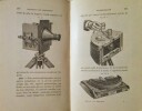
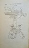
Instruction sur l'emploi du théodolite Jobin.
Bruxelles, Institut Cartographique Militaire, 1935. 14 x 22, 204-11 pages, 1 grande planche dépliante et volante, reliure d'édition pleine percaline brune, bon état (1 cachet d'ex-propriétaire).
Annexe : Carte magnétique de la Belgique, 8 pages, 1 grande carte dépliante en 3 couleurs.
Le service géographique de l'armée : son histoire, son organisation, ses travaux .
1938 Ministère de la Défense , Paris : Impr. du Service géographique de l'Armée, 1938,1 vol. broché,in folio,(191 p.-109 p. de pl.) ill.32 cm. Photos n/b à in et/ou hors-textes , cartes couleurs , plans ,L'historique du Service géographique de l'Armée pour les 50 premières années, de son institution ( 1887 ) à la date de ce beau livre 1938.Bon état.
Belle documentation d'environ de plus de 200 Pages et très nombreuses planches, relatant " la nouvelle Carte de France " au 50.000 dont l'exécution demeure la tache principale à cette époque de ce service et nous livre ainsi tout l'intérêt pour le public de mieux connaitre le formidable travail de ces militaires au service de la cartographie.Ce volume résume le gout des belles cartes et de tous les efforts pour aboutir à l'excellence. Glorification de ceux qui ont précédés au Service Géographique, grâce à cette énorme documentation principalement orchestré par le colonel de Fontanges ainsi que le Colonel Baras et Monsieur le professeur Martin pour la partie rédactionnelle. Remise de 20% pour toutes commandes supérieures à 200 €
Les Portulans. Cartes marines du XIIIe au XVIIe siècle
Paris, Nathan, 1984, in-4, relié, jaquette éditeur, 295 pages. Etat de neuf. Sous emboîtage muet.

Cahier-méthode de cartographie. Pédagofiche. France et colonies. Cours moyen et Certificat d'études primaires
Monot H. Dos agrafé In-8 (17,8 x 21,8 cm), dos agrafé, 40 pages, sans date ; rabat du premier plat frotté et fendu aux extrémités, par ailleurs assez bon état général. Livraison a domicile (La Poste) ou en Mondial Relay sur simple demande.
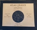
Atlas céleste par l'Abbé Moreux. Compléments par Didier Godillon. Aspects du Ciel visible dans nos régions pour chaque mois de l'année.
1967 Paris, Editions Doin-Deren et Cie, 1967; in-4 oblong en feuilles de 26 p. dont 12 cartes en bleu marine et blanc , couverture blanche à large encadrement bleuet illustré au centre di 1er plat, texte en sépia. Document cartographique dû à l'abbé Moreux, paru pour la 1ère fois en 1947. Il est ici et complété dans cette 2e édition par Didier Godillon. Théophile Moreux, ordonné Prêtre en 1891, astronome et météorologiste, fut nommé Directeur de l'Observatoire de Bourges (Cher), membre de la Société astronomique de France (à partir de 1893).
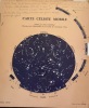
On a joint : "Carte céleste mobile" établie par Pierre Bourge, directeur de l'Observatoire de St -Aubin de Courteraie, Orne. (Paris Jeanniot, 1965); chemise de papier fort beige de 29 X 24 cm, dans laquelle est inséré la carte bleu nuit que l'on peut faire tourner à l'aide d'onglets. Instructions imprimées au verso de la chemise. Annotations manuscrites au crayon au recto.( CO1/CH1)
AJIA REKISHI CHIZU ( ATLAS HISTORIQUE DE L’ASIE). En langue japonaise
Heibonsha, Tokyo, 1966
Un volume petit i, 4°, reliure éditeur couleur vieil orange, lettrage doré, contenu dans un étui illustré sur le 1er plat (un sablier), 148 pages, avec texte et nombreuses cartes en couleurs. TRES BON ETAT.
Die Entwickelung des Kartenbildes der Nord- und Ostseeländer bis auf Mercator. Mit besonderer Berücksichtigung Deutschlands. (Nachdruck).
Amsterdam, Meridian, 1967, gr. in-8°, V + 84 S., Original-Leinenband.
Photomechanischer Nachdruck. Study on mediaeval and renaissance cartography of the North Sea and Baltic area.
(SLACES, NVVA)
Phone number : 41 (0)26 3223808
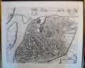
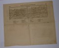
AVENIO vulgo AVIGNON
Célèbre plan de la ville d’Avignon. De grandes dimensions, de nombreux détails apparaissent. Certainement un des plus beaux plans. Cadre doré. Petite fente dans le pli originel de la planche. Bon état Encadré très bon Avignon 1671 42,0 x 52,5 cm. 54 x 62 cm avec le cadre.
édition originale
MOSSELMANS Jean, CHOUQUER Gérard, DE GRAEVE Jan, WAHA Michel de, et autres
Reference : 90575
ISBN : 2870931328
Des agrimensores romains aux arpenteurs du XVIe siècle.
Bruxelles, UGEB, 2001. 21 x 29, 210 pp., broché, très bon état.
Catalogue de l'exposition organisée à l'occasion du 125e anniversaire de l'Union des Géomètres-Experts immobiliers de Bruxelles.
La Topographie.
Nombreuses figures. Paris, Gauthier-Villars et Fils & G. Masson, Éditeur «Encyclopédie Scientifique des Aide-Mémoire, publiée sous la direction de M. Léauté», sans date. In-8 (19x11cm) cartonnage éditeur beige orné. 203pp.
Ce volume est une publication de l'Encyclopédie scientifique des Aide-Mémoire; F. Lafargue, ancien élève de l'École Polytechnique, Secrétaire général, 169, Boulevard Malesherbes, Paris.
Karte des Kantons Zürich 1566.
Zürich. Matthieu. 1967 58 x 48 cm. 6 Holzschnitte und 10 Bordürenteile. In Originalmappe.
Lonchamp 2531. - Eines von 800 nummerierten Exemplaren. Mit den erhaltenen Kupferplatten gedruckter Nachdruck. Murer, bekannt als der Schöpfer des Murer-Stadtplanes, stammte aus Zürich und war "die bedeutendste Erscheinung unter den Zürcher Buchillustratoren dieser Epoche" (Leemann-van Elck). Er war ein Patenkind Christoph Froschauers und über mehrere Jahre hinweg Mitarbeiter in Tobias Stimmers Strassburger Offizin. - Die erste detaillierte Karte des Zürcher-Gebiets (Masstab 1:56000) und gilt als eine der schönsten Holzschnittkarten der Schweiz. Zusammengesetzt misst die Karte 124 x 104 cm.
Gouvernement Général du Languedoc divisé en ses vingt deux diocèses.
Encadré Très bon 1650 31 x 39 cm avec le cadre.
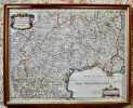
édition originale
Die Statt Montpellier mit ihrer Gelegenheit. Sans date.
"4 pages in-4° extraites d'une édition 16° siècle en allemand de la Cosmographie de Sebastian Munster dont la gravure sur bois représentant la ville de Montpellier; un petit trou en partie inférieure et un petit accident sur la légende supérieure sinon très bon état. Carte 31 cm x 10,3 cm"
Phone number : 06.31.29.75.65
ANNALEN VAN DE KONINKLIJKE OUDHEIDKUNDIGE KRING VAN HET LAND VAN WAAS.deel 85,
, Sint-Niklaas, 1982.**, Originele geillustreerde uitgeversomslag z/w, 17,5x27cm, 190pp, geillustreerd in kleur en z/w.
Jaarboek, deel 85. Verhaal van de ontdekking en inventaris der vondsten van Thof van Appelsvoorde... Een toverbeeld Na Moganga van de Bakongo (Zaire)??
ANNALEN VAN DE KONINKLIJKE OUDHEIDKUNDIGE KRING VAN HET LAND VAN WAAS. Deel 76,
, Sint-Niklaas, 1973.**, Originele geillustreerde uitgeversomslag z/w, 17,5x27cm, 185 - 322pp, geillustreerd z/w.
Jaarboek, deel 76, 3e en 4e aflevering. Jan Benedict Hemelaer & Theodoor Hemelaer... Frans van Brussel... De Penningkohieren, rijke bron van lokale geschiedenis...
ANNALEN VAN DE KONINKLIJKE OUDHEIDKUNDIGE KRING VAN HET LAND VAN WAAS.deel 88,
, Sint-Niklaas, 1985 Originele geillustreerde uitgeversomslag z/w, 16x24cm, 319pp, geillustreerd z/w.
Jaarboek, deel 88. De Sint-Andries-en Gislenuskerk te Belsele: archeologische en kunsthistorische studie... Klapdorp, een 'misplaatst' toponiem: een brede benadering van een toponymisch probleem... Enkele De Lauter-schandpalen in het Land van Waas... De turfwinnersdorpen Kieldrecht en Verrebroek in 1934: twee stadia in de evolutie van een proto-industriele naar een agrarische produktiewijze...Wase bibliografie 1983 - 1984...
ANNALEN VAN DE KONINKLIJKE OUDHEIDKUNDIGE KRING VAN HET LAND VAN WAAS. Deel 91,
, Sint-Niklaas, 1988.**, Originele geillustreerde uitgeversomslag z/w, 16x24cm, 349pp, geillustreerd z/w.
Jaarboek, deel 91. Lotgevallen van de Keure van Waas, 1241 - 1988: een geschiedenis van zeven eeuwen... De 19de eeuwse krankzinnigenzorg te Sint-Niklaas: het Sint-Hieronymusgesticht, 1852 - 1874... Eploitatiemethoden, uitrusting en reglementering in de Vlaamse binnenvisserij...Wase bibliografie 1987...
ANNALEN VAN DE KONINKLIJKE OUDHEIDKUNDIGE KRING VAN HET LAND VAN WAAS.deel 92,
, Sint-Niklaas, 1989.(db)**, Originele geillustreerde uitgeversomslag z/w, 16x24cm, 319pp, geillustreerd z/w.
Jaarboek, deel 92. Het middelbaar landbouwonderwijs voor jongens in de 20ste eeuw... De herberg in het Land van waas... Wase notabelen en politieke regimes... Bevolking, arbeid en strukturele mutaties in het Land van waas in de 19de eeuw... Rupelmonde van 1150 - 1550: een grafelijke enklave in de 19de eeuw... Milieuvervuiling, een aktueel oud zeer: de Zwarte Beek te Sint-Niklaas...Wase bibliografie 1988...
ANNALEN VAN DE KONINKLIJKE OUDHEIDKUNDIGE KRING VAN HET LAND VAN WAAS. deel 95,
, Sint-Niklaas, 1992, Originele geillustreerde uitgeversomslag z/w, 16x24cm, 320pp, geillustreerd z/w.
Jaarboek, deel 95. Index op de publikaties van de Koninklijke Oudheidkundige Kring van het Land van Waas (1862 - 1991)... Verslag over de werking van de Koninklijke Oudheidkundige kring van het Land van Waas tijdens het jaar 1991... Verslag van de werkgroep Bibliotheek en Archief van de K.O.K.W. over het jaar 1991.
ANNALEN VAN DE KONINKLIJKE OUDHEIDKUNDIGE KRING VAN HET LAND VAN WAAS.deel 96/1,
, Sint-Niklaas, 1993.**, Originele geillustreerde uitgeversomslag z/w, 16x24cm, 247pp, geillustreerd z/w.
Jaarboek, deel 96/1. De beeldhouwers Adrianus Nijs ( 1683 - 1771) en Philippus Nijs (1724 - 1805); De achtiende eeuwse beeldhouwkunst in de Zuidelijke Nederlanden... Biografie Adrianus en Philippus Nijs... Oeuvre van Adrianus en Phlippus Nijs.
Atlas. Geschiedenis, wetenschap en beeldende kunst.
Turnhout, Warande, 1990 Hardcover, 92pp., 24.5x34.5cm., ills. in kleur en z/w., goede staat.
BIJDRAGEN TOT DE GESCHIEDENIS BIJZONDERLIJK VAN HET OUD HERTOGDOM BRABANT. Jaargang 42, 3de reeks, 11de deel: aflevering 4.
, Antwerpen, 1959., originele geillustreerde uitgeversomslag z/w, 16x24cm, 177 - 243pp.
Jaargang 42, 3de reeks, 11de deel: aflevering 4. Het einde van het Unionisme te Antwerpen.
BIJDRAGEN TOT DE GESCHIEDENIS BIJZONDERLIJK VAN HET OUD HERTOGDOM BRABANT. Jaargang 46, 3de reeks, 15de deel: aflevering 3 - 4
, Antwerpen, 1963., originele geillustreerde uitgeversomslag z/w, 16x24cm, 139 - 232pp.
Jaargang 46, 3de reeks, 15de deel: aflevering 3 - 4. Duffelse persoons- en plaatsnamen ( 1370 - 1439)... Het Antwerps geslacht Vledincx alias Tarrax ( 15de - 16de eeuw)... Enkele aantekeningen betreffende Florent le Comte 's relaas over de reis van Gerard Seghers naar Italie en Spanje... De dertiende-eeuwse charters van het Victorinnenklooster bij Biezelinge...
BIJDRAGEN TOT DE GESCHIEDENIS BIJZONDERLIJK VAN HET OUD HERTOGDOM BRABANT. Jaargang 44, 3de reeks, 13de deel: aflevering 4
, Antwerpen, 1961., originele geillustreerde uitgeversomslag z/w, 16x24cm, 147 - 192pp.
Jaargang 44, 3de reeks, 13de deel: aflevering 4. Tussen taalstrijd en arbeidsbeweging: de 'onafhankelijke volkspartij' in de jaren 1860...Boekbespreking...Addenda... Congres over Kempische Keurboeken te Geel...
BIJDRAGEN TOT DE GESCHIEDENIS BIJZONDERLIJK VAN HET OUD HERTOGDOM BRABANT. Jaargang 42, 3de reeks, 11de deel: aflevering 3
, Antwerpen, 1959., Originele geillustreerde uitgeversomslag z/w, 16x24cm, 113 - 176pp.
Jaargang 42, 3de reeks, 11de deel: aflevering 3. Floris Prims en de Kempen... Een status Bonorum van het O.-L.-Vrouwekapittel te Antwerpen ( 1346 - 1362)... Een antwerpse Schepenbrief van 1346... De Cijnsrol der Kerk te Kontich... L' accesion de Jacques Speecq au decanat de saint-Pierre a Louvain ( 1653 - 1654)...