 Write to the booksellers
-
Type
Autograph (3)
Book (24726)
Drawings (9)
Engraving (16)
Magazine (132)
Maps (19)
Music sheets (41)
Old papers (3)
Photographs (8)
Postcards (3)
Posters (1)
Public sale (1)
-
Latest
Last 24h (16)
Last 3 days (20)
Last month (207)
Last week (79)
-
Language
Czech (1)
Dutch (1)
English (24)
French (24929)
German (3)
Italian (1)
Latin (1)
Spanish (2)
-
Century
15th (1)
16th (9)
17th (79)
18th (549)
19th (4415)
20th (9949)
21st (1303)
-
Countries
Belgium (401)
Canada (41)
Côte d'Ivoire (10)
Denmark (753)
France (22140)
Germany (206)
Greece (4)
Italy (1)
Netherlands (4)
Switzerland (1402)
-
Syndicate
ALAC (41)
CLAM (5)
CLAQ (35)
CNE (16)
ILAB (14041)
NVVA (315)
SLACES (311)
SLAM (12809)
SNCAO (9)
ENSEMBLE A POMPEI
FALANGA EDIZIONI POMPEIANE. non daté. In-8. Broché. Bon état, Couv. convenable, Dos satisfaisant, Intérieur frais. 64 pages. Nombreuses photos en couleurs dans le texte et hors texte.. . . . Classification Dewey : 910.4-Voyages
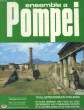
Classification Dewey : 910.4-Voyages
PROVINCIAE, REGIONIS GALLIAE, VERA EXACTISSIMAQ DESCRIPTIO. Petro Ioanne Bompario auctore. PROVENCE.
1595 [Anvers], Ortelius, 1594. Carte (557 X 405 mm, marges comprises) sous cadre en bois noirci moderne.
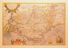
CARTE DE LA PROVENCE fin XVIe en coloris d'époque, tirée de l'atlas d'Ortelius, le premier atlas moderne du monde. Cette carte est ornée de deux cartouches, de voilier et galion avec chaloupe. BELLE CARTE ANCIENNE, RARE, décorative, en très bel état et bien encadrée. NICE COPY. PICTURES AND MORE DETAILS ON REQUEST.
Phone number : 06 21 78 12 79
VENISE - GUIDE ILLUSTRE.
ARDO VENEZIA. 1965. In-12. Broché. Bon état, Couv. convenable, Dos satisfaisant, Intérieur frais. 127 pages illustrées de nombreuses photos couleur - Augmenté d'une grande carte couleur et quelques plans.. . . . Classification Dewey : 910.4-Voyages
Classification Dewey : 910.4-Voyages
VOYAGE EN THAÏLANDE
ARTHAUD. Non daté.. In-8. Broché. Bon état, Couv. convenable, Dos satisfaisant, Intérieur frais. 128 pages. Couverture illustrée en couleur. Nombreuses illustrations en couleur dans le texte.. . . . Classification Dewey : 910.4-Voyages
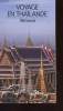
Classification Dewey : 910.4-Voyages
L'Amérique telle qu'elle est, voyage anecdotique de Marcel Bonneau dans le nord et le sud des Etats-Unis, excursion au Canada
Achille Faure | Paris 1864 | 11 x 18 cm | relié
Edition originale. Reliure en pleine basane tête-de-nègre, dos à quatre nerfs orné de caissons dorés et décorés, encadrements à froid sur les plats, gardes et contreplats de papier à la cuve, tranches dorées, reliure de l'époque. Ouvrage illustré de 2 gravures, l'une en frontispice et l'autre sur la page de titre. Petites rousseurs éparses. Rare. - Photographies et détails sur www.Edition-Originale.com -
Phone number : 01 56 08 08 85
L'Amérique telle qu'elle est. Voyage anecdotique de Marcel Bonneau dans le nord et le sud des Etats-Unis. Excursion au Canada
Achille Faure | Paris 1864 | 11.50 x 18 cm | relié
Edition originale dont il n'est pas fait mention de grand papier. Reliure en demi basane verte, dos lisse passé et frotté orné de quadruples filets dorés, plats de papier marbré, gardes et contreplats de papier à la cuve, modeste reliure de l'époque. Quelques rousseurs. Ouvrage illustré de 2 gravures dont l'une en frontispice. - Photographies et détails sur www.Edition-Originale.com -
Phone number : 01 56 08 08 85
Rio
Avenir editora | Rio de Janeiro 1980 | 21.50 x 26.50 cm | reliure de l'éditeur
Edition originale consistant en le fac-similé du manuscrit autographe de l'ouvrage. Reliure de l'éditeur en plein cartonnage blanc, dos lisse, plats illustrés de dessins d'Oscar Niemeyer. Bel exemplaire complet de sa jaquette illustrée comportant de très légers déchirures et manques sans gravité. Ouvrage illustré de dessins d'Oscar Niemeyer. Rare envoi autographe daté et signé d'Oscar Niemeyer à Georges et Alice (Raillard). Georges Raillard fut un critique d'art et un proche ami d'Antoni Tapies et Joan Miro ; sa femme Alice traduisit en français les principaux auteurs brésiliens de la seconde moitié du XXème siècle comme Jorge Amado. - Photographies et détails sur www.Edition-Originale.com -
Phone number : 01 56 08 08 85
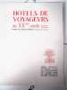
Hôtels de Voyageurs au XXème siècle.
Paris, Librairie Centrale d’Art et d’Architecture, sans date. In-folio, 33 x 46 cm. Feuilles sous chemise à lacets en demi-toile crème. 20 pp., 60 pl. Exemplaire bien complet de ses 60 planches sur l’Hôtel du Grand Condé (Chantilly), Montreux-Palace (Suisse), Beau-Rivage-Palace (Ouch-Lausanne, Suisse), Royal-Hôtel (Evian-les-Bains), Regina-Palast (Munich, Allemagne), Hôtel Moderne (Tarbes), Glockenhof (Zurich, Suisse), Hôtel Cosmopolitain (Contrexéville), Hôtel Esplanade (Berlin, Allemagne), Hôtel Eskualduna (Hendaye-Plage). Fascinant ouvrage sur l’architecture des grands hôtels européens.
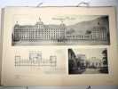
Salissures sur la chemise, sinon bel exemplaire. - Clients Livre Rare Book : Les frais postaux indiqués sont ceux pour la France métropolitaine et la Corse, pour les autres destinations, merci de contacter la librairie pour connaître le montant des frais d'expédition, merci de votre compréhension. Livre Rare Book Customers : The shipping fees indicated are only for France, if you want international shipping please contact us before placing your order, thank you for your understanding. - Frais de port : -Colissimo France 17 € -Colissimo International (Union Européenne + Suisse : 30 €) (Reste du Monde : 80 €)
Phone number : +33 6 18 71 03 67
La Médecine du zemstwo en Russie.
MOSCOU, 1900, Aperçu du développement de la médecine du zemstwo en Russie en général, et dans le gouvernement de Moscou en particulier, accompagné d'un petit exposé statistique sur le pays et son état sanitaire. Avec cartes, plans et diagrammes. Moscou, Imprimerie S. Y
La médecine du Zemsto est une organisation sanitaire et médicale dont le principal but est de donner des soins à la population des campagnes. "Zemlia" : La terre; "Zemstwo" : Institutions territoriales. Désormais les frais d'envoi sont de 6 € seulement pour les livres jusqu'à 1 kg (colissimo suivi), pour la France métropolitaine.
Géographie statistique de la France et de ses colonies, suivie d’une description des quatres parties du monde et d’un abrégé de la sphère et du globe
Versailles & Paris, Arthus-Bertrand 1808 In-12 pleine basane, dos lisse orné, 6- 576 pp. Reliure défraîchie : mors fendillés, taches, usures et manques. En l’état.
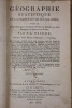
L’auteur dirigeait une maison d’éducation à Versailles. Bon état d’occasion Livres anciens
CATEDRAL DE SAL. UNA IGLESIA ESCAVADA EN LA ENTRANA DEL MONTE.
MOVIFOTO, S.A.. NON DATE. In-16. Broché. Bon état, Couv. convenable, Dos satisfaisant, Intérieur frais. Environ 20 pages. Premier plat illustré en couleurs. Nombreuses illustrations en couleurs dans et hors texte. Texte en espagnol.. . . . Classification Dewey : 910-Géographie générale. Voyages
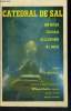
Classification Dewey : 910-Géographie générale. Voyages
LE SACRE A JAVA ET A BALI
ROBERT LAFFONT. 1969. In-8. Broché. Bon état, Couv. convenable, Dos satisfaisant, Intérieur frais. 241 pages. Nombreuses photos en noir et blanc dans le texte et hors texte. Couverture rempliée.. . . . Classification Dewey : 910.4-Voyages
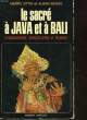
Chamanisme, sorcellerie et transe. Texte d'Alban Bensa. Photographies de Bernard Magos, Eddy Tahitu et Merry Ottin. Classification Dewey : 910.4-Voyages
Conseils aux touristes de 1793
Editions Hier & Demain / La Courtille. Non daté. In-8. Relié. Bon état, Couv. convenable, Dos satisfaisant, Intérieur frais. Environ 200 pages augmentées de nombreuses illustrations en noir et blanc hors texte. Fac-similé. Une illustration dépliante sur le second contre-plat. Une étiquette sur la coiffe en-tête.. . . . Classification Dewey : 910.4-Voyages
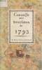
Classification Dewey : 910.4-Voyages
Conseils aux touristes de 1793.
Editions de la Courtille / Hier & Demain. 1971. In-8. Relié. Bon état, Couv. convenable, Dos satisfaisant, Intérieur frais. 162 pages - quelques illustrations en noir et blanc hors texte.. . . . Classification Dewey : 910.4-Voyages
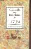
Classification Dewey : 910.4-Voyages
La vallee des rois- la malédiction de toutankhamon
Robert Laffont 1967 302 pages in8. 1967. Broché couverture rempliée. 302 pages. La Vallée des Rois d'Otto Neubert est un ouvrage de vulgarisation historique qui retrace la découverte du tombeau de Toutankhamon en 1922 à laquelle l'auteur a personnellement participé. Le livre mêle récit d'aventure étude ethnologique et évocation de la vie fastueuse des pharaons s'adressant à un large public grâce à un style prenant

Bon état intérieur
OTTO WILLI GAIL - Traduit de l'allemand par Claude Des Périers
Reference : 123395
(1930)
Un voyage dans la lune
1930 Editions Albin Michel, Paris - 1930 - In-8, cartonnage illustré, dos toilé rouge avec titre et décors en noir - 317 pages
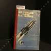
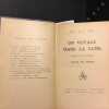
Assez bon état - Menus frottements sur les tranches avec de petits manques de matière - Coiffes tassées - Légers frottements sur les plats - Intérieur bien propre Assez bon
La piste tragique Numero 22
J. Ferenczi & Fils Editeurs 1933 in12. 1933. Broché.
Bon état pages jaunies intérieur propre
Les pélerins du Moyen Age. Les hommes, les chemins, les sanctuaires.
1963 P., Fayard (Collection "Résurrection du Passé"), 1963, in 8°, broché, 214 pages ; nombreuses illustrations.
...................... Photos sur demande ..........................
Phone number : 04 77 32 63 69
Pélerins du Moyen-Age. Les hommes, les chemins, les sanctuaires.
1978 P., Fayard, 1978, in 8°, broché, 277 pages, illustrations.
...................... Photos sur demande ..........................
Phone number : 04 77 32 63 69
Le port de Boulogne-sur-Mer au XIXe siècle
Editions Le Téméraire, collection Terres septentrionales de France, La Sentinelle, 1995. In-8, broché sous couverture illustrée en couleur, 286 pp. Avant-propos - Préambule : La chambre de commerce - Première Partie : Une croissance limitée par l'insuffisance des infrastructures de transport (1815-1850) : Chapitre I. La Pêche : activité dominante. - Chap. II. Le commerce maritime et le passage transmanche ...
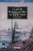
Illustrations et tableaux en noir et blanc in texte. --- Plus d'informations sur le site archivesdunord.com
Phone number : 01 42 73 13 41
Les deux Flandres - La France à Table
La France à Table, Paris, n° 87, décembre 1960. In-4, broché sous couverture illustrée, 48 pp. Les Deux Flandres, par Le ChevalierPierre van Outryve d'Ydewalle, gouverneur de la Flandre Orientale- Bruges et la Flandre Occidentale, par Philippe Heist - Itinéraire touristique - Gand et la Flandre Orientale, par Albert Wieze - La gastronomie en Flandres, par ...
Illustrations en noir et blanc in texte. --- Plus d'informations sur le site archivesdunord.com
Phone number : 01 42 73 13 41
LES MERVEILLES DU MONDE
1950 reliure demi chagrin vert foncé in-quarto, dos long - pièce de titre sur fond or, premier plat décoré à froid et titre frappé or, deuxième plat décoré à froid, tête lisse dorée, illustrations photographiques et planches en couleurs d'après les aquarelles de M. Gérardin, 424 pages, sans date (les années 1930-40 environ) à Paris Librairie Hachette,
bon état
L'ILLUSTRATION - divers -
1931 rel. d. chagr. in-4 double jésus, d. t- titre frappé or - déc. à froid -, tr. jasp., denoël et steel éd.,
table : le pape dans le monde contemporain - l'algérie 1830-1930 - exposition coloniale 1931 (plan de l'exposition) - 1 pièce en 5 actes MISS BA de rudolf besier - bon état -
ouvrage collectif, MOLLAT (Commandant), GAUTHIER Joseph-Stany, BAUDOUIN (Docteur), MOISAN, FOUCHE G.
Reference : 4900
(1938)
BULLETIN DE LA SOCIETE ARCHEOLOGIQUE ET HISTORIQUE DE NANTES ET DE LA LOIRE-INFERIEURE 1937
1938 revue (magazine) in-octavo, dos et couverture marrons (brown spine and cover), tranches non rognées (no smooth edges), orné de 7 gravures hors-texte en noir (dont 2 double pages) + 6 gravures in-texte en noir, LII pages de compte rendu de l'Association + 291 pages de mémoires, 1938 à Nantes Bureaux de la Société Archéologique et Historique,
Collection "Bulletin de la Société Archéologique et Historique de Nantes et de la Loire-Inférieure" Tome 77, premier - deuxième - troisième et quatrième trimestres - Extrait du sommaire (contents) : Nantes à l'époque Gallo-Romaine, Fouilles du château de Nantes, cent ans de courses à Nantes par M. Gilbert de la Brosse......74 - Voyages en loire par Coches d'Eau (cornudet)....109 - Maubreuil (Goué)...121 - Silex taillés des stations du Néolithique supérieur à La Haye-Fouassière, Menhirs et pierres christianisés, La Mnémotechnie de l'histoire de bretagne, Excursion archéologique et historique à Cholet - Thouars - Bressuire, Etc. - bon état (very good condition).