 Write to the booksellers
5 books for « sphyroeras v a avra... »Edit
-
Countries
Belgium (1)
France (3)
Netherlands (1)
-
Syndicate
ILAB (2)
SLAM (2)
Maps and map-makers of the Aegean.
Athens, Olkos Ltd, 1985.
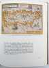
263 p.; illustrations. Cloth. 29 cm (The subject of this richly illustrated book is the mapping of the Aegean Sea, or Greek Archipelago. It has never been a neutral geographical area, forming an indispensible link in the chain of highly significant relations between East and West, and a point of meeting between 2 different civilizations. The maps span the period from the early 15th century, when the first attempts were made in the West to depict a specific area in the form of a map, to recent times. There are woodcuts and lithographs, many maps are copper engravings. The maps record and bear witness to the development of cartographic tools and techniques during 5 centuries)
SPHYROERAS Vasilis - Anna AVRAMEA - Spyros ASDRAHAS - (Translation -) G.COX - J.SOLMAN - :
Reference : 24903
Maps and map makers of the Aegean.
Athens, Olkos Ltd, 1985, in-4°, 261 pp, 166 coloured facsimile plates, bibliography in the notes, index, publisher's cloth, dustwrapper, text in English, ex library with stamps on the first pages, but still a fine copy.
Maps and Map-Makers of the Aegean
Athènes, Olkos, LTD, 1985, in-4, 263 pp, Plein toile orange, Sans jaquette Couverture rigide
Bon 263 pp.
Maps and mapmakers of the Aegean
1985 Olkos ltd reliure cartonnée éditeur, jaquette, 264p. bon état
En anglais. Table : the Aegean since the 15th century - maps of the Aegean - maps - the greek archipelago - a far flung city - map index, general index.
Phone number : 04 76 97 79 28
SPHYROERAS (Vasilis), AVRAMEA (Anna) et ASDRAHAS (Spyros).
Reference : 51470
(1985)
ISBN : B0000ECZTG
Maps and Mapmakers of the Aegean.
Athènes Olkos 1985 1 vol. relié in-4, bradel percaline éditeur, jaquette, 263 pp., nombreuses cartes en couleurs in-texte, index. La cartographie de la mer Egée depuis 1520. Petit accroc au dos de la jaquette, sinon très bon état.