 Write to the booksellers
10 books for « hemsley a »Edit
-
Language
English (2)
French (8)
-
Century
19th (1)
20th (5)
-
Topics
Africa (2)
California (1)
Cartography (1)
Ecosystem (2)
Ethnography (1)
Flora (2)
Flowers (1)
Fruits (2)
Medicine (1)
Morphology (2)
Sciences (1)
Senate (1)
Western (1)
Zoology (1)
-
Countries
France (8)
Switzerland (1)
United States of America (1)
-
Syndicate
ILAB (3)
SLAM (3)
W. Botting Hemsley. Biologia Centrali-Americana. Vol. V. London, 1879.
In English. Short description: W. Botting Hemsley. Biologia Centrali-Americana. or, Contributions to the knowledge of the fauna and flora of Mexico and Central America. Edited by F. Ducane Godman and Osbert Salvin. Botany. Vol. V. London: R.H. Porter andv Dulau & Co., 1879. The book has 110 illustrations (18 of them are colorized) + 1 map. William Hemsley (18431924) was a British botanist who worked at the Royal Botanic Gardens, Kew. In 1889 he was elected a full member of the Royal Society, since 1896 a member of the Linnean Society. During his scientific activity, he described about 50 plant genera and several thousand species. Several plant genera and many species were named after him, the genus name Hemsleya Cogn. Cucurbitaceae family is enshrined in modern botanical nomenclature. Please feel free to contact us for a detailed description of the copies available. SKUMS001911
The book of Fern culture.
1908 in-12, VIII, 112pp., ill., percaline éditeur, plat décoré. London Lane 1908,
Tout sur les fougères.
Phone number : 33 (0)6 77 77 12 33
Eat Happy
Ebury Press (1/2018)
LIVRE A L’ETAT DE NEUF. EXPEDIE SOUS 3 JOURS OUVRES. NUMERO DE SUIVI COMMUNIQUE AVANT ENVOI, EMBALLAGE RENFORCE. EAN:9781785036637
HEMSLEY, J. H. - W. B. Turrill / E. Milne-Redhead (editors)
Reference : 119508
(1956)
Flora of tropical East Africa. Connaraceae.
1956 Published under the authority of the secretary of state for the colonies by the crown agents for oversea governments and administrations - 1956 - In-8, broché - 26 p. - Planches d'illustrations hors texte en N&B - Ouvrage en anglais
Bon état - Auréole au coin inférieur de la 1ère et de la 4ème de couverture
HEMSLEY, J. H. - E. Milne-Redhead / R. M. Polhill (editors)
Reference : 119521
(1968)
Flora of tropical East Africa. Sapotaceae.
1968 Published under the authority of the minister for overseas development by the crown agents for oversea governments and administrations - 1968 - In-8, broché - 78 p. - Planches d'illustrations hors texte en N&B - Ouvrage en anglais
Bon état
DES MEDUSES AUX INSECTES
GAMMA / HERITAGE. NON DATE. In-4. Relié. Bon état, Couv. convenable, Dos satisfaisant, Intérieur frais. 32 pages. Nombreuses photos et/ou illustrations en couleurs,dans et/ou hors texte.. . . . Classification Dewey : 590-Zoologie
Classification Dewey : 590-Zoologie
DES NAGEOIRES AUX AILES
GAMMA-HERITAGE. NON DATE. In-4. Broché. Bon état, Couv. convenable, Dos satisfaisant, Intérieur frais. 32 pages. Nombreuses illustrations et photos en couleurs, dans le texte.. . . . Classification Dewey : 570-Sciences de la vie
"Collection ""Sciences en direct"" Classification Dewey : 570-Sciences de la vie"
De l'alimentation à la digestion
Gamma - Héritage. 1993. In-4. Relié. Bon état, Couv. convenable, Dos satisfaisant, Intérieur frais. 31 pages illustrées en couleurs. tampon sur la page de garde.. . . . Classification Dewey : 610-Sciences médicales. Médecine
"Collection ""Science en direct"". Classification Dewey : 610-Sciences médicales. Médecine"
Notes of a Military Reconnoissance, from Fort Leavenworth, in Missouri, to San Diego, in California ; including parts of the Arkansas, Del Norte, and Gila Rivers.
Washington, Wendell and Van Benthuysen, Printers, 1848. Octavo. xvi, 416 pages. Contemporary half calf, smooth spine gilt with author and title, red edges, stamp on title. Hinge cracked, small loose and label on spine. Large folding map detached and showing browning along the folds. First edition, Senate issue. 30th Congress, 1st Session, Senate, Executive No. 7. Illustrated with 43 plates, including three battle plans of the Mexican–American War (among them the Battle of Pueblo de Los Angeles), early views of California settlements (including San Diego), ethnographic portraits, and botanical plates, and accompanied by the large folding engraved map (33 × 75 inches, environ 84x190cm) The report documenting the military reconnaissance conducted in 1846–1847 during the Mexican–American War by Lieutenant-Colonel William H. Emory of the Corps of Topographical Engineers. The text is divided into two distinct parts : a narrative of the journey itself, combining geographical, logistical, and military observations, followed by extensive appendices presenting the scientific results of the expedition, including meteorological and astronomical observations, geological notes, and natural history data. A primary source for the history of the American Southwest. The plates provide early visual documentation of California, Native American populations, scientific observations, and contemporary military operations. The large folding engraved map, entitled Military Reconnoissance of Arkansas, Rio del Norte, and Rio Gila (dated 1847), is the cartographic centerpiece of the work. Compiled from original field observations, it provides the first comprehensive official mapping of the regions traversed by the expedition, integrating military routes, topography, settlements, barometric profiles, and tables of distances and elevations. The present example corresponds to the second and finalized state. Demi veau époque, dos lisse avec auteur et titre, tranches rouges, cachet au titre, charnière fendues, carte détachée et présentant des brunissures aux plis. Rapport officiel du Sénat sur la reconnaissance de 1846–1847, associant le récit de l’expédition et des annexes scientifiques. Illustré de planches et accompagné de la grande carte dépliante gravée, second état, document cartographique majeur de la guerre américano-mexicaine. Ch.3E
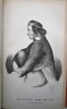
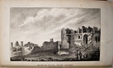
Military reconnaissance, Mexican–American War, Western Americana, Southwest exploration, early California, cartography, Native American ethnography, botanical plates, battle plans, meteorological data, astronomical observations, topographical engineering, Arkansas to San Diego, Senate report, XIX, 19eme
Johnson's Gardeners' Chronicle and cultural instructor.
George Routledge & sons, 1917 (3e édition), 924 p.
Bon état.