Write to the booksellers
4 books for « cruchley g f cr... »Edit
-
Language
English (1)
French (3)
-
Topics
English (1)
Geography (1)
History (1)
London (1)
Maps (1)
United kingdom (1)
-
Countries
Denmark (1)
France (3)
-
Syndicate
ILAB (3)
SLAM (2)
[G. F. Cruchley] - CRUCHLEY, G. F. ; [ CRUCHLEY, George Frederick ]
Reference : 59975
(1852)
Cruchley's Reduction of his Large Map of England and Wales with Part of Scotland ; Showing all the Railways & Turnpike Roads with the Great Rivers and the course of the different Navigable Canals : The Market and Borough Towns and principal places adjoining the Road
Colored folding map, mounted on linen, G. F. Cruchley, 81 Fleet Street, London, s.d. [ circa 1850-1860 ], 79 x 66,5 cm. Full title : Cruchley's Reduction of his Large Map of England and Wales with Part of Scotland ; Showing all the Railways & Turnpike Roads with the Great Rivers and the course of the different Navigable Canals : The Market and Borough Towns and principal places adjoining the Road ; to which is added the distance from one market town to another, with the exact admeasurement prefixed to each from the metropolis.
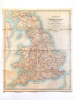

Nice map in its original colors (slight browning on foldings, otherwise a charming map).
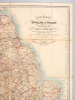
New map of the British Isles shewing all the Railways, principal cross roads, &c
[London], G. F. Cruchley, s.d. [milieu du XIXe siècle], in-16, , Chemise de l'éditeur en percaline bleue, étiquette de titre imprimée en noir contrecollée sur la première couverture, Jolie carte gravée sur cuivre et rehaussée par Cruchley, entoilée et pliée en accordéon sous chemise. Dimensions : environ 650 x 550 mm. Couverture rigide
Bon
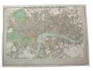
Cruchley's New Plan of London Shewing all the New and Intended Improvements to the Present Time. Published May 1st 1827 - A new Edition, Improved to 1st January 1833.
London, Cruchley map Seller, (1833). (42,5 x 60 cm.) Fine engraved and handcoloured map of London. Updated to 1833. The street- indexes engraved in the margins. The map is in fine condition, plain and not folded.