‎BERTIUS (Petrus).‎
‎ [EMPIRE de CHARLEMAGNE] Imperii Caroli Magni et vicinarum regionum descriptio.‎

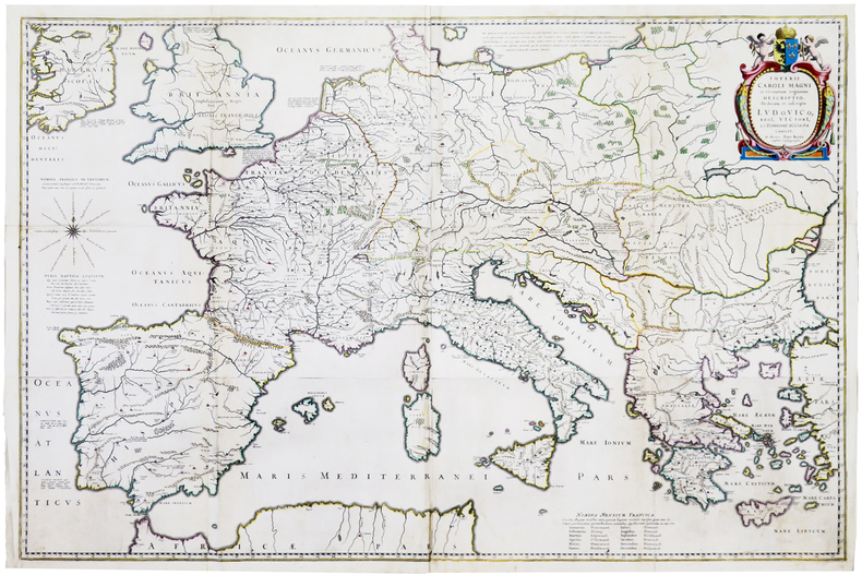
‎Paris, [1620]. En quatre feuilles jointes formant une carte de 640 x 975 mm.‎

Reference : LBW-5945


‎Belle carte murale figurant l'empire de Charlemagne ou empire carolingien autour de la Méditerranée, dressée par Petrus Bertius et publiée par Willem Blaeu dans le Novus Atlas. Contours aquarellés à l'époque. Traces de pliures, petit manque à une pliure. Rare. Koeman, 1050H:2.‎

€1,000.00 (€1,000.00 )
Bookseller's contact details

Librairie Le Bail
Didier Le Bail
13 rue Frédéric Sauton
75005 Paris
France

librairie.lebail@orange.fr

33 01 43 29 72 59

Contact bookseller

Payment mode
Others
Cheque
Others cards

Contact bookseller about this book

Enter these characters to validate your form.
*
Send
Get it on Google Play Get it on AppStore
The item was added to your cart
You have just added :

-

There are/is 0 item(s) in your cart.
Total : €0.00
(without shipping fees)
What can I do with a user account ?

What can I do with a user account ?

  • All your searches are memorised in your history which allows you to find and redo anterior searches.
  • You may manage a list of your favourite, regular searches.
  • Your preferences (language, search parameters, etc.) are memorised.
  • You may send your search results on your e-mail address without having to fill in each time you need it.
  • Get in touch with booksellers, order books and see previous orders.
  • Publish Events related to books.

And much more that you will discover browsing Livre Rare Book !