 Write to the booksellers
JAN JANSSON (1588-1664)
Nova Barbariae descriptio
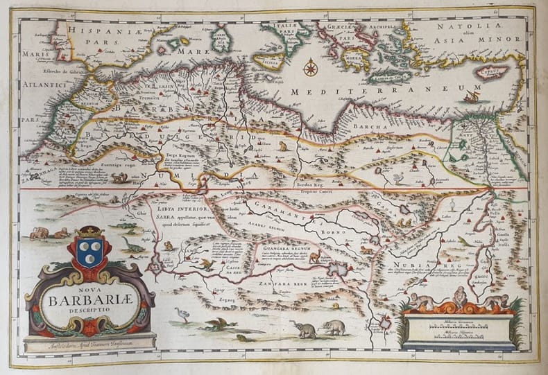
1650
Reference : 18488
TiTOLO: Nova Barbariae descriptio from Nieuwen Atlas Amstelodami, Sumptibus Joannis Janssonii 1650 circa Dimensioni del foglio: 485 x 600 mm. Dimensioni dell'incisione: 355 x 525 mm. Tecnica: incisione su rame Condizioni generali: Eccellenti rare fioriture. Meravigliosa mappa del Nord Africa di grandi dimensioni acquarellata a mano tratta dall'Atlante "Nieuwen Atlas" [translation: The New Atlas], di Jan Jansson, pubblicata ad Amsterdam nel 1650 circa. La mappa mostra anche l'odierno Marocco, Algeria, Tunisia, Libia, Egitto. Titolo decorato con elaborato cartiglio e illustrazioni dell'interpretazione europea della flora e fauna africana. Descrizione completa dell'Egitto e Nord Africa in lingua latina al verso. Jan Jansson, celebre cartografo, appartenente ad una lunga stirpe di stampatori attivi a partire dal XVII secolo. Si stabilirono prima ad Arnhem poi ad Amsterdam. Furono stampatori di mappe, di libri e librai. Title: Nova Barbariae descriptio from Nieuwen Atlas Amstelodami, Sumptibus Joannis Janssonii 1650 circa Sheet size: 19.09 x 23.62 in; 485 x 600 mm. Plate area: 13.98 x 20.67 in; 355 x 525 mm. Technique: Copper engraving Overall condition: Excellent condition, with light foxing. A wonderful large scale hand-colored map of North Africa, from one of the great early 17th-century Atlas "Nieuwen Atlas" [translation: The New Atlas], by Jan Jansson, published in Amsterdam in 1650 circa. The map shows what is now Morocco, Algeria, Tunisia, Libya, Egypt. Elaborately decorated title and illustrations of European interpretations of african flora and fauna. Complete description of Egypt and North Africa in latin language in the verso. Jan Jansson was part of an influential family of map publishers from the Netherland throughout the 17th century and beyond. They were based in Arnhem than in Amsterdam. They were printers, publishers and booksellers. Overall Condition: Excellent
Bookseller's contact details
Sephora di Elena Serru
MRS Elena Serru Serru
via bevagna
06034 Foligno (PG)
Italy
pastpresentfuturebazar@gmail.com
34 92 903 979
Payment mode

Sale conditions
Orders usually ship within 2 business days. Shipping costs are based on books weighing 2.2 LB, or 1 KG. If your book order is heavy or oversized, we may contact you to let you know extra shipping is required. Insurance cost is optional, please ask us for more information. Payment methods accepted are: credit card with abebooks system, paypal, bank transfer. Returns and refundings must be asked within 30 days of the estimated delivery date and the returned items must be received back in the same condition as we sent them. Lost book in transit: We will completely refund you (including shippping cost) if you don¿t receive your book within 14 business days of the estimated delivery date. Incomplete or Incorrect address Provided by customer/unclaimed/Returned to sender: We will refund the book price excluding the shipping cost. Incorrect book/Not as described/Damaged before or in transit: If a return is a result of our error we will completely refund you the purchase price including shipping cost. Return shipping cost are refunded. Customer Changed Mind/Ordered a Wrong Title: We do accept returns but we will refund you the book price only excluding shipping cost. Return shipping cost are on customer charge. The returns right is not valid in the following cases: Some parts of the good purchased are missing; The product is damaged for reasons not due to delivery. If you need more descriptions, have an enquiry or if you need more photoes please contact us.
1 book(s) with the same title
FESSAE, ET MAROCCHI REGNA AFRICAE CELEBERR. [Et] BARBARIAE ET BILEDULGERID, nova descriptio. [2 cartes XVIe du MAROC].
1595 [Anvers], Ortelius, 1595. Deux cartes (51 X 39 cm) et (50 X 33 cm) sous cadres en pichepin.
DEUX CARTES DU MAROC fin XVIe en coloris d'époque tirées de l'atlas d’Ortelius, le premier atlas moderne du monde. Il s'agit des parties atlantique et méditerranéenne du Maroc. Ces cartes sont ornées d'un grand cartouche décoré, de voiliers et de monstres marins. BELLES CARTES ANCIENNES, RARES, décoratives, en très bel état et bien encadrées. NICE COPY. PICTURES AND MORE DETAILS ON REQUEST.
Phone number : 06 21 78 12 79