 Write to the booksellers
Van der Aa, Pieter [Pierre]
L' Irlande : Suivant les Nouvelles Observations de Messrs. de l'Academie Royale des Sciences, etc. : Augmentées de Nouveau
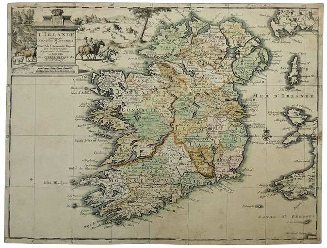
Leiden Pieter van der AA 1713 Gravure sur cuivre, publiée en 1714 à Leyde par Pieter van der Aa En haut à gauche, titre dans un cartouche avec les armoiries du royaume, illustré d'une scène de chasse. Une belle carte coloriée à la main. Découpée près du bord. Quelques rousseurs / marques, mais rien de grave. Les couleurs ont légèrement pâli. La carte se trouve à la page 19 de l'Atlas Le nouveau théâtre du monde ou la géographie royale, publié en 1713. 230 x 300 mm (9 x 11Ÿ pouces). Pierre van der Aa, en collaboration avec divers cartographes néerlandais, français et allemands, est reconnu pour avoir reproduit des cartes de l'Irlande basées sur l'Hiberniae Delineatio de William Petty de 1685, considéré comme le premier atlas complet de l'Irlande. La carte originale de Petty avait été gravée à Amsterdam en 1673 (Tooley, p. 93). Cette carte représente non seulement l'Irlande, mais aussi certaines parties de l'Angleterre, du Pays de Galles et de l'Écosse, ainsi que les îles de Man et d'Anglesey. Van der Aa (1659-1733) était un éditeur néerlandais de cartes et d'atlas réputé qui faisait appel aux meilleurs graveurs de son époque pour produire des uvres d'une grande qualité technique et d'un grand raffinement esthétique.
Reference : 1784
Copper engraving, published in 1714 in Leiden by Pieter van der Aa Top left, title in a cartouche with the arms of the kingdom, illustrated with a hunting scene. A nice hand coloured map. Trimmed closely to the edge. A touch of foxing / marking, but not bad. Colours have faded a little. The map is page 19 of the Atlas Le nouveau théâtre du monde ou la géographie royale, published 1713. 230 x 300 mm (9 x 11Ÿ inches). Pierre van der Aa, together with various Dutch, French, and German cartographers, is recognized for having reproduced maps of Ireland based upon William Petty's Hiberniae Delineatio of 1685, acknowledged as the first comprehensive atlas of Ireland. Petty's original map had been engraved in Amsterdam in 1673 (Tooley, p.93). This map depicts not only Ireland but also portions of England, Wales, and Scotland, along with the islands of Man and Anglesey. Van der Aa (16591733) was a distinguished Dutch publisher of maps and atlases who engaged leading engravers of his time to produce works of superior technical execution and aesthetic refinement.
Bookseller's contact details
Harrison-Hiett Livres Rares
Mrs Marcia Harrison
+33 7 84 03 12 53
Payment mode

Sale conditions
Remboursement intégral si non satisfait de l'état du livre dans les 14 jours suivant la réception