 Write to the booksellers
"GREELY, A. W. (+) FRANZ BOAS.
The Geographical Work of the Greely Expedition [Greely] (+) The Configuration of Grinnell Land and Ellesmere Land [Boas] (+) [Large folded map:] North America polar regions : Baffin Bay to Lincoln Sea, showing the most recent discoveries including tho... - [FIRST ACCOUNT OF THE LADY FRANKLIN BAY EXPEDITION]
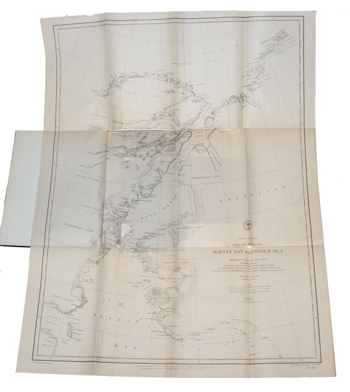
(New York, 1885). 4to. In later half cloth with gilt lettering and stamp to front board. In ""Science"", Vol. 5, No. 108, Feb. 27. Paper label pasted on to front board. The two titles underlined in blue pencil. Stamp to verso of map and almost parted in two, long tear in foldings, otherwise internally fine and clean. Pp. iii-iv, 163-185 + large folded map: ""North America polar regions : Baffin Bay to Lincoln Sea, showing the most recent discoveries including those of U.S.S. Polaris Expedition in 1871-2, under Captain C.F. Hall, British Arctic Expedition in 1875-6, under Captain G.S. Nares, R.N., The Lady Franklin Bay Expedition in 1881-4, under Lieutenant A.W. Greely, U.S.A""
Reference : 58309
First edition of Lieutenant A. W. Greely's first short account of the fatal Lady Franklin Bay Expedition (Also known as the Greely expedition). The present account is presented as a commentary to the accompanying map. A more extensive account was published in 1886 (Three Years of Arctic Service) and the full official account was published in 1888 (Report on the Proceedings of the United States Expedition to Lady Franklin Bay, Grinnell Land)The Lady Franklin Bay Expedition of 1881-1884 to Lady Franklin Bay in the Canadian Arctic was led by Lieutenant Adolphus Greely and its purpose was to establish a meteorological-observation station as part of the First International Polar Year, and to collect astronomical and magnetic data. During the expedition, two members of the crew reached a new Farthest North record, but of the original 25 men, only seven survived to return.""The United States expedition during the First International Polar Year, based at Fort Conger, Lady Franklin Bay, about 81°45' N, on the east coast of Ellesmere Island, explored the north coast of Greenland from Cape Bryant to Cape Washington, about 82°30'-83°30"" N, the interior and west coast of Grinnell Land (northern Ellesmere Island), and extended the maping of Hayes Sound, about 79° N, on Ellesmere. As relief ships failed to reach them, members of the party made a march out of the Hall Basin area, all but seven dying of starvation before rescue at Cape Sabine, Smith Sound"" (Arctic Bibliography).
Bookseller's contact details
Herman H. J. Lynge & Son
William Schneider
Silkegade 11
1113 Copenhagen
Denmark
+45 33 155 335
Payment mode
Sale conditions
All items may be returned for a full refund for any reason within 14 days of receipt.