 Write to the booksellers
-
Type
Art print (1)
Book (47540)
Engraving (79)
Magazine (254)
Manuscript (2)
Maps (116)
Music sheets (3)
Old papers (2)
-
Latest
Last 24h (4)
Last 3 days (281)
Last month (132)
Last week (9)
-
Language
Danish (1)
Dutch (1)
English (22)
French (47932)
German (26)
Italian (4)
Latin (3)
Portuguese (2)
Spanish (6)
-
Century
15th (1)
16th (11)
17th (67)
18th (461)
19th (5265)
20th (25146)
21st (2360)
-
Countries
Belgium (1320)
Brazil (2)
Canada (1)
China (4)
Côte d'Ivoire (19)
Denmark (268)
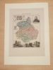
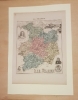
France (43428)
Greece (4)
Italy (821)
Switzerland (2130)
-
Syndicate
ALAC (1)
CLAQ (1)
ILAB (35886)
NVVA (1339)
SLACES (1339)
SLAM (33113)
SNCAO (14)
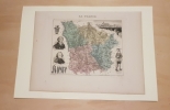
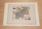
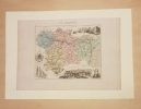
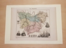
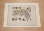
Carte du Département de la MEURTHE
Paris MIGEON 1882 In Plano Carte lithographiée en couleurs , dressée par Vuillemin d'après les cartes de Casini en 1853 , du dépôt de la guerre des Ponts et Chaussées et de la Marine . Extraite de l'Atlas : La France et ses Colonies . Edition de 1882 identique à celle de 1879 . Illustrée des villes , bourgs et cantons , communes ( parfois disparues ) , limites du département , limites des arrondissements , routes de 1ère et 2 ème classes , traverses , chemins de fer et stations , canaux , chemins de fer en construction ,entourée de personnages célèbres , de paysages , d'une vue de la ville principale , du blason , dont les textes sont écrits par Isidore . Format 22 cm x 18 cm ou sur marges de 34 cm x 24 cm , montée sur bristol crème de 42 cm x 30 cm . Envoyée en rouleau . - Cartes et Plans . - Une feuille , 250 gr.
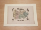
Pas de couverture Très bon
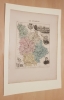
Carte du Département de la MEURTHE ET MOSELLE
Paris MIGEON 1882 In Plano Carte lithographiée en couleurs , dressée par Vuillemin d'après les cartes de Casini en 1853 , du dépôt de la guerre des Ponts et Chaussées et de la Marine . Extraite de l'Atlas : La France et ses Colonies . Edition de 1882 identique à celle de 1879 . Illustrée des villes , bourgs et cantons , communes ( parfois disparues ) , limites du département , limites des arrondissements , routes de 1ère et 2 ème classes , traverses , chemins de fer et stations , canaux , chemins de fer en construction ,entourée de personnages célèbres , de paysages , d'une vue de la ville principale , du blason , dont les textes sont écrits par Isidore . Format 22 cm x 18 cm ou sur marges de 34 cm x 24 cm , montée sur bristol crème de 42 cm x 30 cm . Envoyée en rouleau . - Cartes et Plans . - Une feuille , 250 gr.
Pas de couverture Très bon
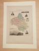
Carte du Département de la MEUSE
Paris MIGEON 1882 In Plano Carte lithographiée en couleurs , dressée par Vuillemin d'après les cartes de Casini en 1853 , du dépôt de la guerre des Ponts et Chaussées et de la Marine . Extraite de l'Atlas : La France et ses Colonies . Edition de 1882 identique à celle de 1879 . Illustrée des villes , bourgs et cantons , communes ( parfois disparues ) , limites du département , limites des arrondissements , routes de 1ère et 2 ème classes , traverses , chemins de fer et stations , canaux , chemins de fer en construction ,entourée de personnages célèbres , de paysages , d'une vue de la ville principale , du blason , dont les textes sont écrits par Isidore . Format 22 cm x 18 cm ou sur marges de 34 cm x 24 cm , montée sur bristol crème de 42 cm x 30 cm . Envoyée en rouleau . - Cartes et Plans . - Une feuille , 250 gr.
Pas de couverture Très bon
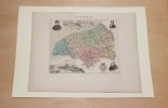
Carte du département de la MOSELLE
Paris MIGEON 1882 In Plano Carte lithographiée en couleurs , dressée par Vuillemin d'après les cartes de Casini en 1853 , du dépôt de la guerre des Ponts et Chaussées et de la Marine . Extraite de l'Atlas : La France et ses Colonies . Edition de 1882 identique à celle de 1879 . Illustrée des villes , bourgs et cantons , communes ( parfois disparues ) , limites du département , limites des arrondissements , routes de 1ère et 2 ème classes , traverses , chemins de fer et stations , canaux , chemins de fer en construction ,entourée de personnages célèbres , de paysages , d'une vue de la ville principale , du blason , dont les textes sont écrits par Isidore . Format 22 cm x 18 cm ou sur marges de 34 cm x 24 cm , montée sur bristol crème de 42 cm x 30 cm . Envoyée en rouleau . - Cartes et Plans . - Une feuille , 250 gr.
Pas de couverture Très bon
Carte du département de la NIEVRE
Paris MIGEON 1882 In Plano Carte lithographiée en couleurs , dressée par Vuillemin d'après les cartes de Casini en 1853 , du dépôt de la guerre des Ponts et Chaussées et de la Marine . Extraite de l'Atlas : La France et ses Colonies . Edition de 1882 identique à celle de 1879 . Illustrée des villes , bourgs et cantons , communes ( parfois disparues ) , limites du département , limites des arrondissements , routes de 1ère et 2 ème classes , traverses , chemins de fer et stations , canaux , chemins de fer en construction ,entourée de personnages célèbres , de paysages , d'une vue de la ville principale , du blason , dont les textes sont écrits par Isidore . Format 22 cm x 18 cm ou sur marges de 34 cm x 24 cm , montée sur bristol crème de 42 cm x 30 cm . Envoyée en rouleau . - Cartes et Plans . - Une feuille , 250 gr.
Pas de couverture Très bon
Carte du Département de l'ARDECHE
Paris MIGEON 1882 In Plano Carte lithographiée en couleurs , dressée par Vuillemin d'après les cartes de Casini en 1853 , du dépôt de la guerre des Ponts et Chaussées et de la Marine . Extraite de l'Atlas : La France et ses Colonies . Edition de 1882 identique à celle de 1879 . Illustrée des villes , bourgs et cantons , communes ( parfois disparues ) , limites du département , limites des arrondissements , routes de 1ère et 2 ème classes , traverses , chemins de fer et stations , canaux , chemins de fer en construction ,entourée de personnages célèbres , de paysages , d'une vue de la ville principale , du blason , dont les textes sont écrits par Isidore . Format 22 cm x 18 cm ou sur marges de 34 cm x 24 cm , montée sur bristol crème de 42 cm x 30 cm . Envoyée en rouleau . - Cartes et Plans . - Une feuille , 250 gr.
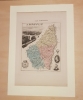
Pas de couverture Très bon
Carte du département de la SARTHE
Paris MIGEON 1882 In Plano Carte lithographiée en couleurs , dressée par Vuillemin d'après les cartes de Casini en 1853 , du dépôt de la guerre des Ponts et Chaussées et de la Marine . Extraite de l'Atlas : La France et ses Colonies . Edition de 1882 identique à celle de 1879 . Illustrée des villes , bourgs et cantons , communes ( parfois disparues ) , limites du département , limites des arrondissements , routes de 1ère et 2 ème classes , traverses , chemins de fer et stations , canaux , chemins de fer en construction ,entourée de personnages célèbres , de paysages , d'une vue de la ville principale , du blason , dont les textes sont écrits par Isidore . Format 22 cm x 18 cm ou sur marges de 34 cm x 24 cm , montée sur bristol crème de 42 cm x 30 cm . Envoyée en rouleau . - Cartes et Plans . - Une feuille , 250 gr.
Pas de couverture Très bon
Carte du département de la SAVOIE
Paris MIGEON 1882 In Plano Carte lithographiée en couleurs , dressée par Vuillemin d'après les cartes de Casini en 1853 , du dépôt de la guerre des Ponts et Chaussées et de la Marine . Extraite de l'Atlas : La France et ses Colonies . Edition de 1882 identique à celle de 1879 . Illustrée des villes , bourgs et cantons , communes ( parfois disparues ) , limites du département , limites des arrondissements , routes de 1ère et 2 ème classes , traverses , chemins de fer et stations , canaux , chemins de fer en construction ,entourée de personnages célèbres , de paysages , d'une vue de la ville principale , du blason , dont les textes sont écrits par J. Bénard . Format 22 cm x 18 cm ou sur marges de 34 cm x 24 cm , montée sur bristol crème de 42 cm x 30 cm . Envoyée en rouleau . - Cartes et Plans . - Une feuille , 250 gr.
Pas de couverture Très bon
Carte du département de la SAÔNE- ET- LOIRE
Paris MIGEON 1882 In Plano Carte lithographiée en couleurs , dressée par Vuillemin d'après les cartes de Casini en 1853 , du dépôt de la guerre des Ponts et Chaussées et de la Marine . Extraite de l'Atlas : La France et ses Colonies . Edition de 1882 identique à celle de 1879 . Illustrée des villes , bourgs et cantons , communes ( parfois disparues ) , limites du département , limites des arrondissements , routes de 1ère et 2 ème classes , traverses , chemins de fer et stations , canaux , chemins de fer en construction ,entourée de personnages célèbres , de paysages , d'une vue de la ville principale , du blason , dont les textes sont écrits par Isidore . Format 22 cm x 18 cm ou sur marges de 34 cm x 24 cm , montée sur bristol crème de 42 cm x 30 cm . Envoyée en rouleau . - Cartes et Plans . - Une feuille , 250 gr.
Pas de couverture Très bon
Carte du département de la SEINE INFERIEURE ( SEINE MARITIME )
Paris MIGEON 1882 In Plano Carte lithographiée en couleurs , dressée par Vuillemin d'après les cartes de Casini en 1853 , du dépôt de la guerre des Ponts et Chaussées et de la Marine . Extraite de l'Atlas : La France et ses Colonies . Edition de 1882 identique à celle de 1879 . Illustrée des villes , bourgs et cantons , communes ( parfois disparues ) , limites du département , limites des arrondissements , routes de 1ère et 2 ème classes , traverses , chemins de fer et stations , canaux , chemins de fer en construction ,entourée de personnages célèbres , de paysages , d'une vue de la ville principale , du blason , dont les textes sont écrits par Duval . Format 22 cm x 18 cm ou sur marges de 34 cm x 24 cm , montée sur bristol crème de 42 cm x 30 cm . Envoyée en rouleau . - Cartes et Plans . - Une feuille , 250 gr.
Pas de couverture Très bon
Carte du département de la SOMME
Paris MIGEON 1882 In Plano Carte lithographiée en couleurs , dressée par Vuillemin d'après les cartes de Casini en 1853 , du dépôt de la guerre des Ponts et Chaussées et de la Marine . Extraite de l'Atlas : La France et ses Colonies . Edition de 1882 identique à celle de 1879 . Illustrée des villes , bourgs et cantons , communes ( parfois disparues ) , limites du département , limites des arrondissements , routes de 1ère et 2 ème classes , traverses , chemins de fer et stations , canaux , chemins de fer en construction ,entourée de personnages célèbres , de paysages , d'une vue de la ville principale , du blason , dont les textes sont écrits par Isidore . Format 22 cm x 18 cm ou sur marges de 34 cm x 24 cm , montée sur bristol crème de 42 cm x 30 cm . Envoyée en rouleau . - Cartes et Plans . - Une feuille , 250 gr.
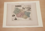
Pas de couverture Très bon
Carte du Département de l'AUBE
Paris MIGEON 1882 In Plano Carte lithographiée en couleurs , dressée par Vuillemin d'après les cartes de Casini en 1853 , du dépôt de la guerre des Ponts et Chaussées et de la Marine . Extraite de l'Atlas : La France et ses Colonies . Edition de 1882 identique à celle de 1879 . Illustrée des villes , bourgs et cantons , communes ( parfois disparues ) , limites du département , limites des arrondissements , routes de 1ère et 2 ème classes , traverses , chemins de fer et stations , canaux , chemins de fer en construction ,entourée de personnages célèbres , de paysages , d'une vue de la ville principale , du blason , dont les textes sont écrits par Isidore . Format 22 cm x 18 cm ou sur marges de 34 cm x 24 cm , montée sur bristol crème de 42 cm x 30 cm . Envoyée en rouleau . - Cartes et Plans . - Une feuille , 250 gr.
Pas de couverture Très bon
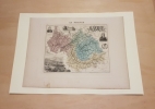
Carte du Département de l'AUDE
Paris MIGEON 1882 In Plano Carte lithographiée en couleurs , dressée par Vuillemin d'après les cartes de Casini en 1853 , du dépôt de la guerre des Ponts et Chaussées et de la Marine . Extraite de l'Atlas : La France et ses Colonies . Edition de 1882 identique à celle de 1879 . Illustrée des villes , bourgs et cantons , communes ( parfois disparues ) , limites du département , limites des arrondissements , routes de 1ère et 2 ème classes , traverses , chemins de fer et stations , canaux , chemins de fer en construction ,entourée de personnages célèbres , de paysages , d'une vue de la ville principale , du blason , dont les textes sont écrits par Isidore . Format 22 cm x 18 cm ou sur marges de 34 cm x 24 cm , montée sur bristol crème de 42 cm x 30 cm . Envoyée en rouleau . - Cartes et Plans . - Une feuille , 250 gr.
Pas de couverture Très bon
Carte du département de la VENDEE
Paris MIGEON 1882 In Plano Carte lithographiée en couleurs , dressée par Vuillemin d'après les cartes de Casini en 1853 , du dépôt de la guerre des Ponts et Chaussées et de la Marine . Extraite de l'Atlas : La France et ses Colonies . Edition de 1882 identique à celle de 1879 . Illustrée des villes , bourgs et cantons , communes ( parfois disparues ) , limites du département , limites des arrondissements , routes de 1ère et 2 ème classes , traverses , chemins de fer et stations , canaux , chemins de fer en construction ,entourée de personnages célèbres , de paysages , d'une vue de la ville principale , du blason , dont les textes sont écrits par Isidore . Format 22 cm x 18 cm ou sur marges de 34 cm x 24 cm , montée sur bristol crème de 42 cm x 30 cm . Envoyée en rouleau . - Cartes et Plans . - Une feuille , 250 gr.
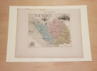
Pas de couverture Très bon
Carte du Département de l'AVEYRON
Paris MIGEON 1882 In Plano Carte lithographiée en couleurs , dressée par Vuillemin d'après les cartes de Casini en 1853 , du dépôt de la guerre des Ponts et Chaussées et de la Marine . Extraite de l'Atlas : La France et ses Colonies . Edition de 1882 identique à celle de 1879 . Illustrée des villes , bourgs et cantons , communes ( parfois disparues ) , limites du département , limites des arrondissements , routes de 1ère et 2 ème classes , traverses , chemins de fer et stations , canaux , chemins de fer en construction ,entourée de personnages célèbres , de paysages , d'une vue de la ville principale , du blason , dont les textes sont écrits par Isidore . Format 22 cm x 18 cm ou sur marges de 34 cm x 24 cm , montée sur bristol crème de 42 cm x 30 cm . Envoyée en rouleau . - Cartes et Plans . - Une feuille , 250 gr.
Pas de couverture Très bon
Carte du département de la VIENNE
Paris MIGEON 1882 In Plano Carte lithographiée en couleurs , dressée par Vuillemin d'après les cartes de Casini en 1853 , du dépôt de la guerre des Ponts et Chaussées et de la Marine . Extraite de l'Atlas : La France et ses Colonies . Edition de 1882 identique à celle de 1879 . Illustrée des villes , bourgs et cantons , communes ( parfois disparues ) , limites du département , limites des arrondissements , routes de 1ère et 2 ème classes , traverses , chemins de fer et stations , canaux , chemins de fer en construction ,entourée de personnages célèbres , de paysages , d'une vue de la ville principale , du blason , dont les textes sont écrits par Housselin et Isidore . Format 22 cm x 18 cm ou sur marges de 34 cm x 24 cm , montée sur bristol crème de 42 cm x 30 cm . Envoyée en rouleau . - Cartes et Plans . - Une feuille , 250 gr.
Pas de couverture Très bon
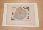
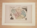
Carte du Département de L' EURE
Paris MIGEON 1882 In Plano Carte lithographiée en couleurs , dressée par Vuillemin d'après les cartes de Casini en 1853 , du dépôt de la guerre des Ponts et Chaussées et de la Marine . Extraite de l'Atlas : La France et ses Colonies . Edition de 1882 identique à celle de 1879 . Illustrée des villes , bourgs et cantons , communes ( parfois disparues ) , limites du département , limites des arrondissements , routes de 1ère et 2 ème classes , traverses , chemins de fer et stations , canaux , chemins de fer en construction ,entourée de personnages célèbres , de paysages , d'une vue de la ville principale , du blason , dont les textes sont écrits par Isidore . Format 22 cm x 18 cm ou sur marges de 34 cm x 24 cm , montée sur bristol crème de 42 cm x 30 cm . Envoyée en rouleau . - Cartes et Plans . - Une feuille , 250 gr.
Pas de couverture Très bon
Carte du Département de L' EURE ET LOIR
Paris MIGEON 1882 In Plano Carte lithographiée en couleurs , dressée par Vuillemin d'après les cartes de Casini en 1853 , du dépôt de la guerre des Ponts et Chaussées et de la Marine . Extraite de l'Atlas : La France et ses Colonies . Edition de 1882 identique à celle de 1879 . Illustrée des villes , bourgs et cantons , communes ( parfois disparues ) , limites du département , limites des arrondissements , routes de 1ère et 2 ème classes , traverses , chemins de fer et stations , canaux , chemins de fer en construction ,entourée de personnages célèbres , de paysages , d'une vue de la ville principale , du blason , dont les textes sont écrits par Isidore . Format 22 cm x 18 cm ou sur marges de 34 cm x 24 cm , montée sur bristol crème de 42 cm x 30 cm . Envoyée en rouleau . - Cartes et Plans . - Une feuille , 250 gr.
Pas de couverture Très bon
Carte du Département de L' HERAULT
Paris MIGEON 1882 In Plano Carte lithographiée en couleurs , dressée par Vuillemin d'après les cartes de Casini en 1853 , du dépôt de la guerre des Ponts et Chaussées et de la Marine . Extraite de l'Atlas : La France et ses Colonies . Edition de 1882 identique à celle de 1879 . Illustrée des villes , bourgs et cantons , communes ( parfois disparues ) , limites du département , limites des arrondissements , routes de 1ère et 2 ème classes , traverses , chemins de fer et stations , canaux , chemins de fer en construction ,entourée de personnages célèbres , de paysages , d'une vue de la ville principale , du blason , dont les textes sont écrits par Bixet . Format 22 cm x 18 cm ou sur marges de 34 cm x 24 cm , montée sur bristol crème de 42 cm x 30 cm . Envoyée en rouleau . - Cartes et Plans . - Une feuille , 250 gr.
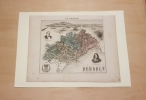
Pas de couverture Très bon
Carte du Département de L'ILLE ET VILAINE
Paris MIGEON 1882 In Plano Carte lithographiée en couleurs , dressée par Vuillemin d'après les cartes de Casini en 1853 , du dépôt de la guerre des Ponts et Chaussées et de la Marine . Extraite de l'Atlas : La France et ses Colonies . Edition de 1882 identique à celle de 1879 . Illustrée des villes , bourgs et cantons , communes ( parfois disparues ) , limites du département , limites des arrondissements , routes de 1ère et 2 ème classes , traverses , chemins de fer et stations , canaux , chemins de fer en construction ,entourée de personnages célèbres , de paysages , d'une vue de la ville principale , du blason , dont les textes sont écrits par Bixet . Format 22 cm x 18 cm ou sur marges de 34 cm x 24 cm , montée sur bristol crème de 42 cm x 30 cm . Envoyée en rouleau . - Cartes et Plans . - Une feuille , 250 gr.
Pas de couverture Très bon
Carte du Département de L'INDRE
Paris MIGEON 1882 In Plano Carte lithographiée en couleurs , dressée par Vuillemin d'après les cartes de Casini en 1853 , du dépôt de la guerre des Ponts et Chaussées et de la Marine . Extraite de l'Atlas : La France et ses Colonies . Edition de 1882 identique à celle de 1879 . Illustrée des villes , bourgs et cantons , communes ( parfois disparues ) , limites du département , limites des arrondissements , routes de 1ère et 2 ème classes , traverses , chemins de fer et stations , canaux , chemins de fer en construction ,entourée de personnages célèbres , de paysages , d'une vue de la ville principale , du blason , dont les textes sont écrits par Isidore . Format 22 cm x 18 cm ou sur marges de 34 cm x 24 cm , montée sur bristol crème de 42 cm x 30 cm . Envoyée en rouleau . - Cartes et Plans . - Une feuille , 250 gr.
Pas de couverture Très bon
Carte du Département de L'INDRE ET LOIRE
Paris MIGEON 1882 In Plano Carte lithographiée en couleurs , dressée par Vuillemin d'après les cartes de Casini en 1853 , du dépôt de la guerre des Ponts et Chaussées et de la Marine . Extraite de l'Atlas : La France et ses Colonies . Edition de 1882 identique à celle de 1879 . Illustrée des villes , bourgs et cantons , communes ( parfois disparues ) , limites du département , limites des arrondissements , routes de 1ère et 2 ème classes , traverses , chemins de fer et stations , canaux , chemins de fer en construction ,entourée de personnages célèbres , de paysages , d'une vue de la ville principale , du blason , dont les textes sont écrits par Del Fillatreau . Format 22 cm x 18 cm ou sur marges de 34 cm x 24 cm , montée sur bristol crème de 42 cm x 30 cm . Envoyée en rouleau . - Cartes et Plans . - Une feuille , 250 gr.
Pas de couverture Très bon
Carte du Département de L'ISERE
Paris MIGEON 1882 In Plano Carte lithographiée en couleurs , dressée par Vuillemin d'après les cartes de Casini en 1853 , du dépôt de la guerre des Ponts et Chaussées et de la Marine . Extraite de l'Atlas : La France et ses Colonies . Edition de 1882 identique à celle de 1879 . Illustrée des villes , bourgs et cantons , communes ( parfois disparues ) , limites du département , limites des arrondissements , routes de 1ère et 2 ème classes , traverses , chemins de fer et stations , canaux , chemins de fer en construction ,entourée de personnages célèbres , de paysages , d'une vue de la ville principale , du blason , dont les textes sont écrits par Del Fillatreau . Format 22 cm x 18 cm ou sur marges de 34 cm x 24 cm , montée sur bristol crème de 42 cm x 30 cm . Envoyée en rouleau . - Cartes et Plans . - Une feuille , 250 gr.
Pas de couverture Très bon
Carte du département de L'OISE
Paris MIGEON 1882 In Plano Carte lithographiée en couleurs , dressée par Vuillemin d'après les cartes de Casini en 1853 , du dépôt de la guerre des Ponts et Chaussées et de la Marine . Extraite de l'Atlas : La France et ses Colonies . Edition de 1882 identique à celle de 1879 . Illustrée des villes , bourgs et cantons , communes ( parfois disparues ) , limites du département , limites des arrondissements , routes de 1ère et 2 ème classes , traverses , chemins de fer et stations , canaux , chemins de fer en construction ,entourée de personnages célèbres , de paysages , d'une vue de la ville principale , du blason , dont les textes sont écrits par Isidore . Format 22 cm x 18 cm ou sur marges de 34 cm x 24 cm , montée sur bristol crème de 42 cm x 30 cm . Envoyée en rouleau . - Cartes et Plans . - Une feuille , 250 gr.
Pas de couverture Très bon
Carte du département de L'ORNE
Paris MIGEON 1882 In Plano Carte lithographiée en couleurs , dressée par Vuillemin d'après les cartes de Casini en 1853 , du dépôt de la guerre des Ponts et Chaussées et de la Marine . Extraite de l'Atlas : La France et ses Colonies . Edition de 1882 identique à celle de 1879 . Illustrée des villes , bourgs et cantons , communes ( parfois disparues ) , limites du département , limites des arrondissements , routes de 1ère et 2 ème classes , traverses , chemins de fer et stations , canaux , chemins de fer en construction ,entourée de personnages célèbres , de paysages , d'une vue de la ville principale , du blason , dont les textes sont écrits par Isidore . Format 22 cm x 18 cm ou sur marges de 34 cm x 24 cm , montée sur bristol crème de 42 cm x 30 cm . Envoyée en rouleau . - Cartes et Plans . - Une feuille , 250 gr.
Pas de couverture Très bon