 Write to the booksellers
-
Type
Book (360)
Maps (516)
New book (1)
-
Language
English (1)
French (874)
German (1)
Spanish (1)
-
Century
17th (38)
18th (71)
19th (302)
20th (39)
21st (2)
-
Countries
Belgium (178)
France (662)
Switzerland (37)
-
Syndicate
ILAB (119)
NVVA (33)
SLACES (33)
SLAM (86)
CARTE GEOGRAPHIQUE DEPARTEMENTALE ALLIER Gravé par ALES et écrit par ISIDORE. D'après la carte de Cassini , du dépot de la guerre , des ponts et chaussées et de la marine par M. VUILLEMIN.
PARIS MIGEON 1884, 0 , 35 X 0 , 26 Feuillet Gravée sur acier et aux contours coloriés,bon état,
franco port lettre pour la France Remise de 20% pour toutes commandes supérieures à 200 €
CARTE GEOGRAPHIQUE DEPARTEMENTALE ALPES-MARITIMES Gravé par SMITH , écrit par BENARD. D'après la carte de Cassini , du dépot de la guerre , des ponts et chaussées et de la marine par M. VUILLEMIN.
PARIS MIGEON 1884, 0 , 35 X 0 , 26 Feuillet Gravée sur acier et aux contours coloriés,bon état,
franco port lettre pour la France Remise de 20% pour toutes commandes supérieures à 200 €
CARTE GEOGRAPHIQUE DEPARTEMENTALE ARDECHE Gravé par VILLEREY , écrit par ISIDORE. D'après la carte de Cassini , du dépot de la guerre , des ponts et chaussées et de la marine par M. VUILLEMIN.
PARIS MIGEON 1884, 0 , 35 X 0 , 26 Feuillet Gravée sur acier et aux contours coloriés,bon état,
franco port lettre pour la France Remise de 20% pour toutes commandes supérieures à 200 €
CARTE GEOGRAPHIQUE DEPARTEMENTALE ARDENNES Gravé par E. DUCHIER , écrit par ISIDORE. D'après la carte de Cassini , du dépot de la guerre , des ponts et chaussées et de la marine par M. VUILLEMIN.
PARIS MIGEON 1884, 0 , 35 X 0 , 26 Feuillet Gravée sur acier et aux contours coloriés,bon état,
franco port lettre pour la France Remise de 20% pour toutes commandes supérieures à 200 €
CARTE GEOGRAPHIQUE DEPARTEMENTALE ARIEGE Gravé par Ch. DYONNET , vues par VILLEREY. D'après la carte de Cassini , du dépot de la guerre , des ponts et chaussées et de la marine par M. VUILLEMIN. Format 24x18
PARIS MIGEON 1884, 0 , 35 X 0 , 26 Feuillet,Gravée sur acier et aux contours coloriés,bon état,
franco port lettre pour la France Remise de 20% pour toutes commandes supérieures à 200 €
CARTE GEOGRAPHIQUE DEPARTEMENTALE AUBE Gravé par ALES , écrit par ISIDORE. D'après la carte de Cassini , du dépot de la guerre , des ponts et chaussées et de la marine par M. VUILLEMIN.
PARIS MIGEON 1884, 0 , 35 X 0 , 26 Feuillet,Gravée sur acier et aux contours coloriés,bon état,
franco port lettre pour la France Remise de 20% pour toutes commandes supérieures à 200 €
CARTE GEOGRAPHIQUE DEPARTEMENTALE AUDE Gravé par Ch. DYONNET , vues par VILLEREY. D'après la carte de Cassini , du dépot de la guerre , des ponts et chaussées et de la marine par M. VUILLEMIN. Format 24x18
PARIS MIGEON 1884, 0 , 35 X 0 , 26 Feuillet,Gravée sur acier et aux contours coloriés,bon état,
franco port lettre pour la France Remise de 20% pour toutes commandes supérieures à 200 €
CARTE GEOGRAPHIQUE DEPARTEMENTALE BAS-RHIN Gravé par VILLEREY , écrit par ISIDORE. D'après la carte de Cassini , du dépot de la guerre , des ponts et chaussées et de la marine par M. VUILLEMIN. Format 24x18
PARIS MIGEON 1871, 0 , 35 X 0 , 26 Feuillet,Gravée sur acier et aux contours coloriés,bon état,
bon tirage sur papier fort, Remise de 20% pour toutes commandes supérieures à 200 €
CARTE GEOGRAPHIQUE DEPARTEMENTALE BASSES-ALPES Gravé par Ch. DYONNET , vues par VILLEREY. D'après la carte de Cassini , du dépot de la guerre , des ponts et chaussées et de la marine par M. VUILLEMIN.
PARIS MIGEON 1884, 0 , 35 X 0 , 26 Feuillet,Gravée sur acier et aux contours coloriés,bon état,
franco port lettre pour la France Remise de 20% pour toutes commandes supérieures à 200 €
CARTE GEOGRAPHIQUE DEPARTEMENTALE BASSES PYRENEES Gravé par ALES , écrit par ISIDORE. D'après la carte de Cassini , du dépot de la guerre , des ponts et chaussées et de la marine par M. VUILLEMIN.
PARIS MIGEON 1884, 0 , 35 X 0 , 26 Feuillet,Gravée sur acier et aux contours coloriés,bon état,
franco port lettre pour la France Remise de 20% pour toutes commandes supérieures à 200 €
CARTE GEOGRAPHIQUE DEPARTEMENTALE BOUCHES DU RHONE Gravé par ALES , écrit par ISIDORE. D'après la carte de Cassini , du dépot de la guerre , des ponts et chaussées et de la marine par M. VUILLEMIN.
PARIS MIGEON 1884, 0 , 35 X 0 , 26 Feuillet,Gravée sur acier et aux contours coloriés,bon état,
franco port lettre pour la France Remise de 20% pour toutes commandes supérieures à 200 €
CARTE GEOGRAPHIQUE DEPARTEMENTALE CALVADOS Gravé par ALES , écrit par ISIDORE. D'après la carte de Cassini , du dépot de la guerre , des ponts et chaussées et de la marine par M. VUILLEMIN.
PARIS MIGEON 1884, 0 , 35 X 0 , 26 Feuillet,Gravée sur acier et aux contours coloriés,bon état,
franco port lettre pour la France Remise de 20% pour toutes commandes supérieures à 200 €
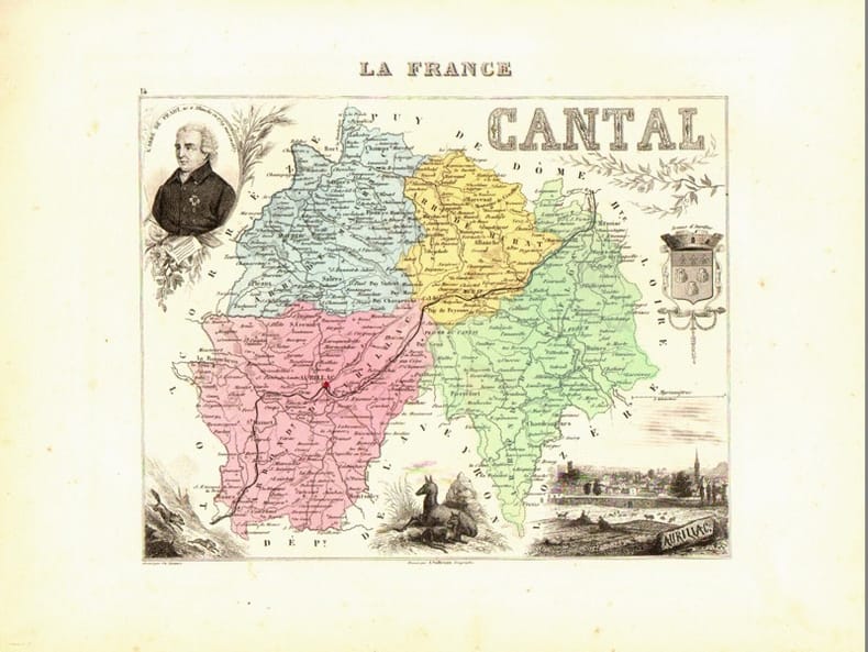
CARTE GEOGRAPHIQUE DEPARTEMENTALE CANTAL Gravé par Ch. DYONNET. D'après la carte de Cassini , du dépot de la guerre , des ponts et chaussées et de la marine par M. VUILLEMIN.
PARIS MIGEON 1884, 0 , 35 X 0 , 26 Feuillet,Gravée sur acier et aux contours coloriés,bon état,
franco port lettre pour la France Remise de 20% pour toutes commandes supérieures à 200 €
CARTE GEOGRAPHIQUE DEPARTEMENTALE CHARENTE Gravé par ALES , écrit par ISIDORE. D'après la carte de Cassini , du dépot de la guerre , des ponts et chaussées et de la marine par M. VUILLEMIN.
PARIS MIGEON 1884, 0 , 35 X 0 , 26 Feuillet,Gravée sur acier et aux contours coloriés,bon état,
franco port lettre pour la France Remise de 20% pour toutes commandes supérieures à 200 €
CARTE GEOGRAPHIQUE DEPARTEMENTALE CHARENTE INFERIEURE Gravé par ALES , écrit par ISIDORE. D'après la carte de Cassini , du dépot de la guerre , des ponts et chaussées et de la marine par M. VUILLEMIN.
PARIS MIGEON 1884, 0 , 35 X 0 , 26 Feuillet,Gravée sur acier et aux contours coloriés,bon état,
franco port lettre pour la France Remise de 20% pour toutes commandes supérieures à 200 €
CARTE GEOGRAPHIQUE DEPARTEMENTALE CHER Gravé par VILLEREY , écrit par ISIDORE. D'après la carte de Cassini , du dépot de la guerre , des ponts et chaussées et de la marine par M. VUILLEMIN.
PARIS MIGEON 1884, 0 , 35 X 0 , 26 Feuillet,Gravée sur acier et aux contours coloriés,bon état,
franco port lettre pour la France Remise de 20% pour toutes commandes supérieures à 200 €
CARTE GEOGRAPHIQUE DEPARTEMENTALE CORREZE Gravé par VILLEREY , écrit par ISIDORE. D'après la carte de Cassini , du dépot de la guerre , des ponts et chaussées et de la marine par M. VUILLEMIN.
PARIS MIGEON 1884, 0 , 35 X 0 , 26 Feuillet,Gravée sur acier et aux contours coloriés,bon état,
franco port lettre pour la France Remise de 20% pour toutes commandes supérieures à 200 €
CARTE GEOGRAPHIQUE DEPARTEMENTALE COTE-D'OR Ecrit par ISIDORE. D'après la carte de Cassini , du dépot de la guerre , des ponts et chaussées et de la marine par M. VUILLEMIN.
PARIS MIGEON 1884, 0 , 35 X 0 , 26 Feuillet,Gravée sur acier et aux contours coloriés,bon état,
franco port lettre pour la France Remise de 20% pour toutes commandes supérieures à 200 €
CARTE GEOGRAPHIQUE DEPARTEMENTALE COTE DU NORD Gravé par Ch. DYONNET , vues par COUCHE. D'après la carte de Cassini , du dépot de la guerre , des ponts et chaussées et de la marine par M. VUILLEMIN.
PARIS MIGEON 1884, 0 , 35 X 0 , 26 Feuillet,Gravée sur acier et aux contours coloriés,bon état,
franco port lettre pour la France Remise de 20% pour toutes commandes supérieures à 200 €
CARTE GEOGRAPHIQUE DEPARTEMENTALE CREUSE Gravé par VILLEREY , écrit par ISIDORE. D'après la carte de Cassini , du dépot de la guerre , des ponts et chaussées et de la marine par M. VUILLEMIN.
PARIS MIGEON 1884, 0 , 35 X 0 , 26 Feuillet,Gravée sur acier et aux contours coloriés,bon état,
franco port lettre pour la France Remise de 20% pour toutes commandes supérieures à 200 €
CARTE GEOGRAPHIQUE DEPARTEMENTALE DEUX SEVRES Gravé par ALES , écrit par ISIDORE. D'après la carte de Cassini , du dépot de la guerre , des ponts et chaussées et de la marine par M. VUILLEMIN.
PARIS MIGEON 1884, 0 , 35 X 0 , 26 Feuillet,Gravée sur acier et aux contours coloriés,bon état,
franco port lettre pour la France Remise de 20% pour toutes commandes supérieures à 200 €
CARTE GEOGRAPHIQUE DEPARTEMENTALE DORDOGNE Les vues par VILLEREY. D'après la carte de Cassini , du dépot de la guerre , des ponts et chaussées et de la marine par M. VUILLEMIN.
PARIS MIGEON 1884, 0 , 35 X 0 , 26 Feuillet,Gravée sur acier et aux contours coloriés,bon état,
franco port lettre pour la France Remise de 20% pour toutes commandes supérieures à 200 €
CARTE GEOGRAPHIQUE DEPARTEMENTALE DOUBS Gravé par Ch. DYONNET , vues par VILLEREY. D'après la carte de Cassini , du dépot de la guerre , des ponts et chaussées et de la marine par M. VUILLEMIN.
PARIS MIGEON 1884, 0 , 35 X 0 , 26 Feuillet,Gravée sur acier et aux contours coloriés,bon état,
franco port lettre pour la France Remise de 20% pour toutes commandes supérieures à 200 €
CARTE GEOGRAPHIQUE DEPARTEMENTALE DROME Gravé par VILLEREY , écrit par ISIDORE. D'après la carte de Cassini , du dépot de la guerre , des ponts et chaussées et de la marine par M. VUILLEMIN.
PARIS MIGEON 1884, 0 , 35 X 0 , 26 Feuillet,Gravée sur acier et aux contours coloriés,bon état,
franco port lettre pour la France Remise de 20% pour toutes commandes supérieures à 200 €