 Write to the booksellers
-
Type
Artists book (1)
Autograph (1)
Book (8558)
Engraving (3)
Magazine (5)
Maps (362)
-
Latest
Last 24h (1)
Last 3 days (2)
Last month (50)
Last week (5)
-
Language
English (1)
French (8911)
German (10)
Greek (1)
Italian (1)
Polish (1)
Spanish (5)
-
Century
16th (9)
17th (20)
18th (193)
19th (1502)
20th (2946)
21st (382)
-
Countries
Belgium (148)
Canada (2)
China (28)
Côte d'Ivoire (1)
Denmark (44)
France (8454)
Greece (1)
Switzerland (252)
-
Syndicate
ALAC (2)
CLAQ (2)
CNE (1)
ILAB (7284)
NVVA (132)
SLACES (132)
SLAM (7084)
SNCAO (3)
ITALIE 1/300 000 ATLAS ROUTIER ET TOURISTIQUE
MICHELIN
LIVRE A L’ETAT DE NEUF. EXPEDIE SOUS 3 JOURS OUVRES. NUMERO DE SUIVI COMMUNIQUE AVANT ENVOI, EMBALLAGE RENFORCE. EAN:9782067255074
ESPAGNE & PORTUGAL 2024 - SPIRALE
MICHELIN
LIVRE A L’ETAT DE NEUF. EXPEDIE SOUS 3 JOURS OUVRES. NUMERO DE SUIVI COMMUNIQUE AVANT ENVOI, EMBALLAGE RENFORCE. EAN:9782067261518
Atlas de la Chine. Un monde sous tension.
Autrement, 2012, gr. in-8°, 96 pp, nouvelle édition augmentée, nombreuses cartes en couleurs (cartographie : Madeleine Benoît-Guyod), repères, chronologies, biblio, index, reliure souple illustrée de l'éditeur, bon état
Plus de 120 cartes et infographies pour découvrir le nouveau visage social, économique et politique de la Chine. – Les formidables mutations de la société s'accélèrent : consommation, tourisme, aspirations et revendications nouvelles... – Un géant qui rivalise avec les grandes puissances mondiales. – Les grands enjeux d'avenir en cartes : crises environnementales, transport, santé et vieillissement. – Dans cette nouvelle édition entièrement mise à jour, Thierry Sanjuan souligne à quel point la Chine, à l'écart de la classique suprématie occidentale, invente son propre modèle de puissance développée.
Atlas de géographie moderne.
Paris, Librairie hachette et cie , 1894; in folio , cartonnage de l'éditeur. Reliure demi cuir frotté intérieur bel état.
Reliure demi cuir frotté intérieur bel état.
Atlas géographique.
Paris, Le grand livre du mois, 1983; in-4, 48 pp., cartonnage de l'éditeur. Ouvrage en bon état.
Ouvrage en bon état.
(Atlas Minor) - Atlantis Minoris...
Augsburg, Augustæ Vind, (1744). 4to-oblong. Cont. hcalf. Back and covers somewhat worn. Platesizes ca. 20,5 x 27 cm. (32) pp. and 60 full-page engraved maps (of 64 listed). Lacking the engraved title and 5 other maps (Africa, America septentrionalis, Regum Portugalliæ, Regnum Hispaniæ, Italia totur and Palæstina), but having 2 more not listed and some in the German section does not corresponds with the maps listed in the index. All maps in original handcolouring, occasionally a little brownspotted and traces of use in lower right corners. One map have a little loss of image in lower middle (Austria Saliburgensis).
Phillips No 3494. 2 maps relating to America (Globus Terrestris (World Map) and America Meridionalis). Having maps of Europe, Asia, Russia, Turkey, Scandinavia etc. The World Map engraved by Andr. Silbereisen and most of the other maps engraved by A.C. Seutter and Tobias C. Lotter (married to Seutters daughter and his successor).
Atlas Élémentaire de Geographie ancienne et moderne. Approuvé par le Conseil Royal de l'Université de France. 1.-3. Serie (all).
Paris, J. Andriveau-Goujon, 1841. Folio. Bound in full leather with a closing flap just like a briefcase. Slightly scratched and a few tears to binding. Titlepage with a tear, no loss. Complete with 30 double-page (ca 41x53 cm) full handcoloured engraved maps. A few tears in centerfoldings, very ligh brownspottings, otherwise good.
Philipps No 324 listing an edition from 1838, but not this (second edition ?). This fine engraved atlas comprises 10 historical maps and 20 recent (1841), among these Mappemonde, North-and South America, Asia, Africa, Europe etc.
Chiffres du monde 1989.
Paris, Encyclopaedia Universalis, 1989; grand in-8, 542 pp., cartonnage de l'éditeur. Bon état avec sa jaquette - atlas statistique.
Bon état avec sa jaquette - atlas statistique.
Auswahl von 31 Karten aus Stieler's Hand-Atlas über alle Theile der Erde, nach dem neuesten Zustande, und üiber das Weltgebäude. Schul-Ausgabe.
Gotha, Justus Perthes, 1866. Folio. (38x24,5 cm.). Orig. full cloth, blindstamped and with title on front board in gilt lettering. Spine ends worn and a tear to upper part of first hinge. The printed title pasted on inside of front cover from the publisher. (2) pp. and 31 steel-engraved double-page coloured maps. The first, Planeten-System lightly brownspotted, otherwise fine with a few marginal brownspots to margins.
With maps of all the Continents, Europe, The Hemispheres etc.
Handatlas. Auswahl von 31 Karten.
Gotha, Justus Perthes, (Maps dated 1876). Folio.. Orig. full cloth, blindstamped and gilt frontboard. Corners bumped, edges worn, covers with scratches. (2) pp. and 31 steel-engraved double-page coloured maps. Light browning to lower margins of some maps, otherwise clean.
With maps of all the Continents, Europe, The Hemispheres etc.
Stieler's Hand-Atlas. Auswahl von 31 Karten.
Gotha, Justus Perthes, n.d. (1877-78) Folio. Orig. full blindstamped cloth. Frontcover with gilt title. Lower part of spine (ca. 8 cm.) lacks, and top of spine with some wear, otherwise fine. With 31 double-page (37x43,5) steel-engraved maps with outline colouring. All maps clean and fine. Maps dated 1877 a. the last 1878.
Handatlas über alle Theile der Erde und über das Weltgebäude. 95 Karten.
Gotha, Justus Perthes, (1879-80). Folio-oblong. Contemp. hcalf. Gilt spine. Gilt lettering. Spine somewhat worn. Corners bumped. Wear to edges.Bound in front is ""Vorbemerkungen zu Stieler's Hand-Atlas"" 8 pp. Inhalt (2) pp. and 95 (incl. title-page) engraved and coloured maps. Maps dated 1879/1880, some undated. Maps clean and fine, only few minor marginal brownspots.
Handatlas über alle Theile der Erde und über das Weltgebäude.
Gotha, Justus Perthes, (1873-75). Folio-oblong. Contemp. hcalf. Titlelabel with gilt lettering. Spine somewhat worn and frontcover detached from spine. Stamp on title-page.Bound after title-page ""Vorbericht zu Stieler's Hand-Atlas"", 11 pp. Containing 89 engraved maps in outline colouring (incl. title-page, 1-24, 26-90), A faint dampstain to some maps in upper right corners. Some underlining to German cities. Maps dated 1873, 1874 a. 1875 (mosly 1873).
30 cartes des Environs de Paris. Est.-
Paris. Hachette. Sans date. Petit in-4 (206 x 204 mm) cartonnage dos toile bleue de l'éditeur, 32 cartes en couleurs, accompagnées de commentaires en vis à vis illustrés de photos formant un dictionnaire des communes. Tableau d'assemblage en frontispice. Petits défauts d'usage mais bon exemplaire.
30 cartes des Environs de Paris. Ouest.-
Paris. Hachette. Sans date. Petit in-4 (206 x 204 mm) cartonnage dos toile bleue de l'éditeur, 32 cartes en couleurs, accompagnées de commentaires en vis à vis illustrés de photos formant un dictionnaire des communes. Tableau d'assemblage en frontispice. Petits défauts d'usage mais bon exemplaire.
Cartes generale et particulieres de toutes les costes de France, tant de la mer Oceane que Mediterranee
Paris, Michel Vanlochom 1634 In-4 à l’italienne 26,5 x 39 cm. Reliure plein vélin souple de l’époque, titre manuscrit, 2 ff.- 14 pp. & 32 planches dont 2 de titre gravé, une carte générale repliée restauration sans manque et 29 cartes particulières une infime restauration. Texte sur deux colonnes latin et français en regard. Marges brunies. Humidité marginale éparse. Ex-libris Prosper Falgairolle. Bon exemplaire.
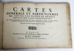
Une des deux éditions publiées la même année. Les 29 cartes visaient à faciliter la défense côtière au plus fort de la Guerre de Trente ans. La première partie trace la côte atlantique de Calais à San Sebastian, la seconde la côte méditerranéenne de la frontière espagnole à Villefranche. Dans les années 1630, Christophe Tassin, commissaire ordinaire des guerres et géographe du roi, fit passer les sources militaires dans la cartographie civile, qu’il renouvelle, alors que les cartes générales sont encore marquées par l’oeuvre de La Guillotière. Bon état d’occasion
The Sea-Coasts of France, from Calais to Bayone. Described in Fifteen Large Charts. Surveyed and Printed by the order of the French King. From the Original, done at Paris, and the Remarks Explained in English, and Published for the Use of His Majesty'...
London, Printed for William Mount and Thomas Page on Tower Hall, no date (c. 1715). Folio. 53X35 cm. Cont. hcalf with marbled boards. Rebacked and recornered in old style with raised bands. Engraved typographical titlepage with a large engraved vignette showing the English King's Coat of Arms. With all 15 double-page engraved sea-charts (numbered (1)-(15) in lower right corners). Neat repairs to inner margins of free endpapers and titlepage. Some browning to charts. Chart 5 (45x75,5 cm) having the right margin shaved reaching the printed frame.
Second edition of this scarce ""Atlas Maritime"". According to Shirley it was first published by Richard Mount and Thomas Page in 1701 and re-issued with undated title (as this) in ab. 1715, but with the charts unchanged and a new engraved titlepage. A third issue came out in 1737 with a dated title. The fine charts are copied from Pieter Mortier's famous ""Neptune Francois"" (1693-1702) and reduzed in size.""The charts in this early Mount & Page atlas ""The Sea-Coasts of France"" are re-engravings, reduzed in size, from the charts in the French Neptune of 1693. The charts may also be found in the 1702 edition of Mount and Page's Atlas Maritimus Novus..."" (Rodney Shirley). - Not in Phillips. - Shirley Vol. II: M.M&P - 12 b.
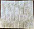
Aigle - Château d'Oex.
Berne, Service topographique fédéral, 1934. Carte au 1:25.000, au format ouvert de 94 x 78 cm.
FLEURIER N°280
SERVICE TOPOGRAPHIQUE FEDERAL. Non daté. In-Folio. Broché. Etat d'usage, Couv. légèrement passée, Dos satisfaisant, Intérieur acceptable. Carte dépliante en 8 volets au 1/25.000e en couleurs.. . . . Classification Dewey : 912-Atlas, cartes et plans
Classification Dewey : 912-Atlas, cartes et plans
LA COTE AUX FEES FEUILLE N°282
SERVICE TOPOGRAPHIQUE FEDERAL. Non daté. In-Folio. Broché. Etat d'usage, Couv. légèrement passée, Dos satisfaisant, Intérieur acceptable. Carte dépliante en 8 volets au 1/25.000e en couleurs.. . . . Classification Dewey : 912-Atlas, cartes et plans
Classification Dewey : 912-Atlas, cartes et plans
MAUBORGET FEUILLE N°284
SERVICE TOPOGRAPHIQUE FEDERAL. Non daté. In-Folio. Broché. Etat d'usage, Couv. convenable, Dos satisfaisant, Intérieur acceptable. Carte dépliante en 8 volets au 1/25.000e en couleurs.. . . . Classification Dewey : 912-Atlas, cartes et plans
Classification Dewey : 912-Atlas, cartes et plans
Ste - CROIX FEUILLER N°283
SERVICE TOPOGRAPHIQUE FEDERAL. Non daté. In-Folio. Broché. Etat d'usage, Couv. convenable, Dos satisfaisant, Intérieur acceptable. Carte dépliante en 8 volets au 1/25.000e en couleurs.. . . . Classification Dewey : 912-Atlas, cartes et plans
Classification Dewey : 912-Atlas, cartes et plans
Nouvel atlas classique physique, politique, historique et commercial divisé en trois parties.
Paris, A alexandre libraire, s.d.; in-8 oblong, 70 pp., demi cuir frotté.
.
La France et ses colonies. Atlas illustré. Cent cartes dressées d'après les cartes de Cassini, du Dépôt de la guerre, des Ponts-et-Chaussées et de la Marine.
Paris-Montrouge, J. Migeon, 1869, gr. in-4° (26 x 35,5), 238 pp, texte sur deux colonnes avec encadrement typographique, 100 cartes hors texte réhaussées en couleurs et ornementées de vignettes en noir, dont certaines cartes à double page montées sur onglets (dont 3 cartes de l'Algérie : provinces d'Alger, de Constantine, d'Oran) et 3 cartes grand format dépliantes (France physique, administrative et routière, Plan de Paris, Chemins de fer et lignes télégraphiques de la France), reliure pleine percaline noire de l'éditeur, dos lisse à caissons à froid et titres dorés, encadrements à froid sur les plats, titre doré au 1er plat et décor doré au second plat, bon état
Texte rédigé d'après les documents officiels et sur un plan entièrement nouveau réunissant en forme de tableaux : 1) La division administrative, politique, judiciaire, religieuse, militaire etc. ; 2) Les Vicissitudes historiques ; 3) La Biographie ; 4) La Satistique ; 5) Les Ressources agricoles, industrielles, commerciales ; 6) Les Etablissements d'instruction ou d'utilité publique ; 7) La Description détaillée de tous les chefs-lieux d'arrondissement et des lieux remarquables ; 8) Enfin les Curiosités et la Physionomie morale de chaque département et de chaque colonie française.
Atlas Géographique du Journal La France Administrative.-
Paris. Georges Hurtrel. Vers 1870. 1 volume in-f° à l'italienne (356 x 263 mm) cartonnage rouge de l'éditeur, titre doré sur le 1er plat, Contient: Mappemonde, Afrique, Amérique, Asie, Europe, Océanie, France, 89 départements, Algérie Isthme de Suez, Colonies françaises et 2 grandes lithographies à 2 teintes de Fichot: Paris et Rome. Complet. Cartes en noir et blanc, chacune entourée d'un même décor évoquant les cinq parties du monde. Mors intérieur du 1er plat faible, Cartonnage un peu fané, très bon état intérieur malgré de tout petits défauts. Rare.