 Write to the booksellers
-
Type
Book (1014)
Drawings (1)
Magazine (13)
Maps (57)
-
Latest
Last 24h (2)
Last month (15)
Last week (2)
-
Language
English (1)
French (1080)
German (3)
Portuguese (1)
-
Century
16th (3)
17th (28)
18th (55)
19th (132)
20th (228)
21st (51)
-
Countries
Belgium (266)
Brazil (1)
Canada (5)
China (1)
Côte d'Ivoire (12)
France (578)
Netherlands (1)
Switzerland (221)
-
Syndicate
ALAC (5)
ILAB (353)
NVVA (129)
SLACES (129)
SLAM (161)
SNCAO (2)
Cartes géographiques anciennes. Evolution de la représentation cartographique du monde : de l'Antiquité à la fin du XIXe siècle
Gründ, 1981, grand in-8 cartonnage toile beige, 240 p., coll. "Beaux objets d'autrefois", 30 illustrations en couleur h.-t., 74 illustrations in-t., jaquette, très bon état.
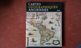
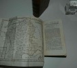
Premier essai du genre en français, cet ouvrage est la traduction d'une étude rédigée en tchèque et dont l'auteur est un disciple du spécialiste bien connu Karel Kuchar. On trouvera dans ce livre, richement illustré, une matière très dense même s'il existe quelques défauts de composition. Utile index in fine. Voir le sommaire sur photos jointes.
Descriptio Austriae : Osterreich und seine Nachbarn im Kartenbild von der Spatantike bis ins 19. Jahrhundert.
, Edition Tusch, 1977 Hardcover, 216 zeiten, Deutsche edition, 330 x 310 x 25 mm, Wie Neu !!, Illustrierter Schutzumschlag, reichhaltig illustriert in Farbe / s/w; ***Teils gefalteten Karten in farbe und s/w*** besondere seltene Ausgabe... ISBN 9783850630740.
Die Geschichte sterreichs umfasst die Geschichte sterreichs und seiner Vorg ngerstaaten. In der sp ten Eisenzeit wurde sterreich von Menschen der keltischen Hallstatt-Kultur besetzt (ca. 800 v. Chr.), die sich zun chst als keltisches K nigreich organisierten, das von den R mern als Noricum bezeichnet wurde und aus dem Jahr ca. stammte. 800 bis 400 v. Chr. Am Ende des 1. Jahrhunderts v. Chr. wurden die Gebiete s dlich der Donau Teil des R mischen Reiches. In der V lkerwanderungszeit, im 6. Jahrhundert, besetzten die Bavarien, ein germanisches Volk, dieses Land, bis es im 9. Jahrhundert an das Frankenreich fiel, das von den germanischen Franken gegr ndet wurde. Der Name Ostarr chi ( sterreich) wird seit 996 n. Chr. verwendet, als es eine Markgrafschaft des Herzogtums Bayern und ab 1156 ein unabh ngiges Herzogtum (sp ter Erzherzogtum) des Heiligen R mischen Reiches (962?1806) war.
Le Nouveau Paris : histoire de ses 20 arrondissements en 1860
1986 Ed. SACELP - 1986 - In-Folio, cartonnage toilé bordeaux sous jaquette illustrée en N&B - 440 p. - 21 cartes topographiques en couleurs dont une dépliante en fin d'ouvrage - 67 illustrations de Gustave Doré en N&B
Bon état - Menus frottement sur la jaquette
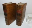
Géographie moderne, précédée d'un petit Traité de la sphère et du globe (---) et terminée par une géographie sacrée et une géographie ecclésiastique (---)par M. l'abbé Nicolle de La Croix. Nouvelle édition, revue par J.-L. Barbeau de La Bruyère. Paris. Delalain fils. An VIII [1799].
2 volumes in-12° reliés demi-basane marbrée, dos à nerfs décorés, petite fissure sur le dos du tome 1 avec accroc en coiffe supérieure, épidermures et traces de frottements sur les plats, coisn émoussés. LIV, 799 p. (ex-libris manuscrit, 3 cartes) - XVI, 849 p. (petites mouillures en début de volume). Bel état interne et d'ensemble sur ces volumes souvent en mauvais état.
Phone number : 06.31.29.75.65
CARTES : Le Voyage immobile.
Grenoble : Éditions Glénat, 2008. 113 pages abondamment illustrées en noir et couleur.
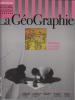
POUVOIR DE L'IMAGE. La carte dit-elle le monde ? / NAVIGATION. Du bois dont on fait les cartes / HÉRITAGE. Trésors de la cartothèque de l'IGN / GEOPORTAIL. La France en un clic / VIRTUEL. Carte et Internet : les nouveaux usages / ANAMORPHOSES. Cartogrammes / ESTRAN. Cartes des côtes de France / GEOLOGIE. Sous-sol de la planète / SUCCULENTES. Gastronomie à la carte / PORTFOLIO. Un monde de cartes / CULTURE. La palette du désert / PATRIMOINE. La Société de Géographie / LE PLUS GÉOGRAPHE DES ÉCRIVAINS. Julien Gracq / L'INTELLIGENCE DU CHEMIN. Archéologie.
Département du Gard
Planche de l'Atlas National Illustré. Dressé par Levasseur. Rehauts de couleurs En feuille Très bon Paris Pelissier Vers 1850 35 x 50 cm
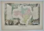
édition originale
Département du Gard
Planche de l'Atlas National Illustré. Dressé par Levasseur. Pas de couverture Très bon Paris Pelissier Vers 1850 35 x 50 cm
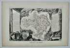
édition originale
Lamarck (Jean-Baptiste de Monet, chevalier de) et Decandolle (Augustin-Pyrame de) :
Reference : 21684
(1805)
Flore française, ou descriptions succintes de toutes les plantes qui croissent naturellement en France, Disposées selon une Nouvelle Méthode d’Analyse, et précédées par un Exposé des Principes élémentaires de la Botanique, Troisième Edition.
Paris, H. Agasse, Imprimerie de Stoupe, an XIII (1805); 4 tomes reliés en 5 volumes in-8 ; veau fauve raciné, dos lisse à décor de style “Bozérian” (reliure de Napoléon), pièces de titre fauve et de tomaison vert empire (reliure de l’époque) ; XVI, 224, (Discours préliminaires et Principes de Botanique), 388 pp., 1 tableau dépliant et 11 planches dépliantes par De Sève ; XII (explication de la carte botanique), 600 pp., très grande carte botanique de la France en couleurs dépliante ; 731 pp. ; (4), 384 pp. ; pp. 385-944, (2) pp.
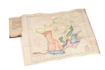
Première édition revue et complétée de façon très importante par Decandolle (la 2e édition n’avait que 3 tomes qui représentaient 1800 pages environ, celle-ci en compte près de 2900 !). On peut à juste titre la considérer comme un ouvrage nouveau, tant les modifications et compléments sont nombreux et importants ; en fait, il s’agit du premier grand ouvrage de botanique du jeune Decandolle, qui s’était fait remarquer déjà avec son “Histoire des plantes grasses”, son travail sur les plantes dormantes et sa thèse de médecine “Essai sur les propriétés médicinales des plantes”. C’est Lamarck, absorbé par ses travaux sur les invertébrés, qui confia à Decandolle la révision de son ouvrage, avec le résultat que l’on sait : 6000 espèces nouvelles, une ingénieuse carte botanique inédite ; il est bien complet, tel que paru. Petite usure aux coiffes des trois premiers tomes, sans gravité et un coin légèrement maché ; malgré ces petits défauts, bel exemplaire dans l’ensemble.
Phone number : 06 60 22 21 35
Heritage Railways of the British Isles (texte en anglais)
1999 Ed. Grange Books - 1999 - In-Folio, cartonage illustré en couleurs sous jaquette illustrée en couleurs - 256 p. - Nombreuses reproductions photographiques et cartes en couleurs et N&B - Texte en anglais

Bon état - Une étiquette collée sur le deuxième plat - Jaquette légèrement insolée
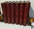
"Nouveau dictionnaire universel, usuel et complet de géographie moderne. Récemment publié par une société de savants, de géographes, d'ingénieurs, professseurs et gens de lettres d'après Maltabrun, Lapie, Balbi, Walkenaer, etc. ; l'Académie des Sciences. Les cartes et plans de la Marine, les dernières découvertes, voyages des navigateurs, et documents inédits jusqu'à ce jour. Extrait et traduit des principales langues de l'Europ rédigés et mis en ordre par Hyacinthe Langlois. Édition compacte de 4000 pages et de 120000 lieux (---), Paris, H. Langlois éditeur-Géographe sans date."
5 volumes in-4° reliés demi-veau bistre, dos à nerfs richement décorés d'une belle frise dorée (Reliuire signée - Lebrun relieur) - Très beaux exemplaires blanc intérieurement.
Phone number : 06.31.29.75.65
LAPIE (Pierre et Émile) [et] JÄCK (Carl); SOTZMANN (Daniel Friedrich)
Reference : 18660
Carte des royaumes de Belgique et de Hollande [et] Carte générale des États Prussiens
Paris, chez Eymery, Fruger et Cie, 1833. 66 x 44 cm [et] Berlin, Simon Schropp et Comp., 1802. 67,5 x 103 cm, étui et chemise (chemise et étui défraîchis, rousseurs, déchirures de la toile).
![Carte des royaumes de Belgique et de Hollande [et] Carte générale des États Prussiens. LAPIE (Pierre et Émile) [et] JÄCK (Carl); SOTZMANN (Daniel ...](https://static.livre-rare-book.com/pictures/TVX/18660_1_thumb.jpg)
![Carte des royaumes de Belgique et de Hollande [et] Carte générale des États Prussiens. LAPIE (Pierre et Émile) [et] JÄCK (Carl); SOTZMANN (Daniel ...](https://static.livre-rare-book.com/pictures/TVX/18660_2_thumb.jpg)
![Carte des royaumes de Belgique et de Hollande [et] Carte générale des États Prussiens. LAPIE (Pierre et Émile) [et] JÄCK (Carl); SOTZMANN (Daniel ...](https://static.livre-rare-book.com/pictures/TVX/18660_3_thumb.jpg)
Carte représentant les royaumes de Belgique et de Hollande. Elle est imprimée sur papier, rehaussée de couleurs et collée sur un pan de toile beige. Il s'agit de la 30e carte de l'Atlas universel de géographie (dont elle porte le timbre sec) des Lapie, père et fils, paru entre 1829 et 1833. [et] Carte représentant des états prussiens. Elle est imprimée sur papier, rehaussée de couleurs et collée sur un pan de brune. Dans un insert dans le coin inférieur gauche, la région de Neuchâtel et Valangin a été représentée car elle appartenait alors à la Prusse, qu'elle quitte en 1848. Voir photographie(s) / See picture(s) * Membre du SLAM et de la LILA / ILAB Member. La librairie est ouverte du lundi au vendredi de 14h à 19h. Merci de nous prévenir avant de passer,certains de nos livres étant entreposés dans une réserve.
La découverte de l'Afrique au moyen âge. Cartographes et explorateurs. Volume 1, L'intérieur du continent. Volume 2, Le périple du continent. Volume 3, Un explorateur français du Niger. Les débuts de Christophe Colomb. Un peintre italien à la cour d'Abyssinie.
Le Caire: Société royale de géographie d'Egypte, 1924-1925-1927 3 tomes in folio reliés en un volume, (3)-viii-174 pp.-(1), 19 planches; (4)-144 pp-(2), 18 planches; (4)-viii-130 pp., 3 pl. Demi reliure maroquin à coins, dos à 4 nerfs richement orné, tête dorée, couvertures conservées, Suberbe exemplaire. Volume 1, L'intérieur du continent. Volume 2, Le périple du continent. Volume 3, Un explorateur français du Niger. Les débuts de Christophe Colomb. Un peintre italien à la cour d'Abyssinie. Mémoires de la Société royale de géographie d'Egypte, tomes V, VI, XIII.
La découverte de l'Afrique au moyen âge. Cartographes et explorateurs. Volume 1, L'intérieur du continent. Volume 2, Le périple du continent. Volume 3, Un explorateur français du Niger. Les débuts de Christophe Colomb. Un peintre italien à la cour d'Abyssinie. (Le Caire: Société royale de géographie d'Egypte, 1924-1925-1927). [M.C.: Afrique, cartographie, histoire des découvertes]
Les portulans. Cartes marines du XIIIe au XVIIe siècle. Avec le concours de M(arie)-M(ad.) Azard, I(sabelle) Raynaud-Nguyen und M(arie)-A(nt.) Vannerau.
Fribourg, Office du Livre, 1984, gr. in-4°, 296 p., qqs ill. n/b et richement illustré de cartes en couleurs, reliure en toile originale, jaquette ill. en couleurs.
Première édition. Les belles cartes reproduites ici témoignent d'abord de la curiosoiité scientifique et de l'intérêt popur les pays lointains qui s'emparent du monde occidental à la fin du Moyen Age. Tracées et souvent enluminées avec le plus grand soin, elles sont aussi des oeuvres d'art.Matières e.a.: L'image du monde avant les cartes-portulans / Une nouvelle image du monde: la carte-portulan / Le "choc" ptoléméen et la cartographie des découvertes / Antériorité des écoles cartographiques méditerranéennes / Les écoles du Ponant / L'audience du Portulan / Commentaires aux 100 planches / Bibliographie / Glossaire. Image disp.
(SLACES, NVVA)
Phone number : 41 (0)26 3223808
LA RONCIÈRE Monique de - MOLLAT du JOURDIN Michel
Reference : 057354
ISBN : 2826401327
LES PORTULANS. Cartes marines du XIIIe au XVIIe siècle
Fribourg Office du Livre 1984 in folio (34,5x25) 1 fort volume reliure cartonnée de l'éditeur, sous jaquette illustrée en couleurs, 295 pages. Très bel exemplaire ( Photographies sur demande / We can send pictures of this book on simple request )
Très bon Très bon Couverture rigide
LA RONCIÈRE Monique de - MOLLAT du JOURDIN Michel
Reference : 057527
ISBN : 2092905384
LES PORTULANS. Cartes marines du XIIIe au XVIIe siècle
Fribourg Nathan 1984 in folio (34,5x25) 1 fort volume reliure toilée bleue de l'éditeur, sous jaquette illustrée en couleurs, 295 pages, étui. Très bel exemplaire ( Photographies sur demande / We can send pictures of this book on simple request )
Très bon Très bon Couverture rigide
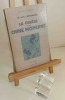
La genèse de la Chine moderne. Bibliothèque géographique. Paris. Payot. 1947.
1 volume in-8° broché, 153 p., 7 cartes. Très bon état d'occasion.
Phone number : 06.31.29.75.65
Les GRANDES ALPES dans la CARTOGRAPHIE (1482-1885)
Un ouvrage de 360 pages en couleurs, grand format, nombreuses illustrations, relié sous jaquette illustrée et coffret
Histoire de la cartographie alpine
Phone number : 04 74 33 45 19
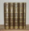
Géographie universelle de Malte-Brun entièrement refondue et mise au courant de la science. Furne, Jouvet et Cie. Paris. 1869.
"6 volumes in-4° reliés demi-chagrin rouge à coins, titre doré, fleurons dorés, épidermures sur les coins, anciennes étiquettes colées sur le dos et petite pièce de ruban noir au dos du tome 1. VIII, 722 p., 731, 722;, 687, 739 Gravures hors-texte. Rousseurs éparses. Petites traces de frottement sur les nerfs et les mors. Coin du tome 4 abîmé. Bons exemplaires."
Phone number : 06.31.29.75.65
L'évolution de la cartographie de la région du Mont-Cenis et de ses abords aux XVème et XVIème
1949 Librairie Dardel, Chambéry, 1949. In-4 broché. 125 pages, 12 planches, 2 cartes
très bon exemplaire d'un ouvrage rare
Les Gorges du Tarn. Montpellier le vieux et curiosités des causses, guide géographique, historique & pittoresque avec une Carte en couleur.
Toulouse, Mende Durand, Fillous & Lagarde, imprimeurs, Privat, Masseguin 1889 In-8 - 15x23cm. Broché. 109pp.
Couvertures et dos avec d'infimes petites déchirures et manques, sinon bel exemplaire. Exemplaire bien complet de sa carte dépliante in fine. Première édition. Publiée par la "Société de géographie de Toulouse" qui fut à l'origine de la découverte des splendeurs des Gorges du Tarn et de ses grottes. - Clients Livre Rare Book : Les frais postaux indiqués sont ceux pour la France métropolitaine et la Corse, pour les autres destinations, merci de contacter la librairie pour connaître le montant des frais d'expédition, merci de votre compréhension. Livre Rare Book Customers : The shipping fees indicated are only for France, if you want international shipping please contact us before placing your order, thank you for your understanding. - Frais de port : -Colissimo France 9,5 € -Colissimo International (Union Européenne + Suisse : 20 €) (Reste du Monde : 40 €) -Mondial Relay France 6 €
Phone number : +33 6 18 71 03 67
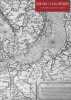
Portraits de la France et du monde
Importante documentation due aux excellents catalogues de la Librairie Le Bail-Weissert. Printemps 2007. Cartes et vues de villes du Xvè au XIXè siècle. Broché sous couverture illustrée Très bon Paris 2007 1 volume in-4°
Plans et cartes. Graphiques et diagrammes. Guide des travaux pratiques de géographie à l'usage des établissements scolaires.
Couverture souple. Broché. 54 pages.

Livre. Editions André Lesot - Librairie Istra, 1951.
Etude géomorphologique et cartographique : Ile de Groix - Lorient
Dos carré collé In-4 (21 x 29,5 cm), dos thermocollé, 158 pages, sans date ni mention d'éditeur, document tapuscrit ; quelques traces et marques d'usage sur les plats et tranches, coins du premier plat recourbés, par ailleurs intérieur frais, assez bon état. Livraison a domicile (La Poste) ou en Mondial Relay sur simple demande.
Le mystère français
2013 Ed. du Seuil / La République des Idées - Coll. La République des idées (dirigée par Pierre Rosanvallon et Ivan Jablonka) - 2013 - Fort In-8 broché - 309 p. - Nombreuses cartes de la France en couleurs
Bon état - Rares passages soulignés sur les dernières pages de l'ouvrage
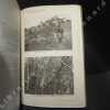
Contribution à l'étude de la flore du parc national de la Kagera. Exploration du Parc National de la Kagera, Mission J. Lebrun (1937-1938), Fascicule 1. Exploratie van het National Park der Kagera, Zendig J. Lebrun (1937-1938), Aflevering 1.
1948 Institut des Parcs Nationaux du Congo Belge / Instituut der Nationale Parken van Belgisch Congo - 1948 - In-8, broché - 160 p. - Planches hors texte en N&B en fin d'ouvrage - Ouvrage non coupé (jamais lu)
Bon état - Fentes en bas du dos fragilisant le brochage - Légères rousseurs et insolation sur la couverture