 Write to the booksellers
-
Type
Book (1891)
Drawings (1)
Magazine (13)
Maps (61)
-
Latest
Last 24h (1)
Last 3 days (2)
Last month (31)
Last week (8)
-
Language
French (1962)
German (3)
Portuguese (1)
-
Century
16th (4)
17th (17)
18th (48)
19th (143)
20th (371)
21st (37)
-
Countries
Belgium (249)
Canada (3)
China (1)
Côte d'Ivoire (5)
France (1427)
Italy (52)
Switzerland (229)
-
Syndicate
ALAC (3)
ILAB (402)
NVVA (129)
SLACES (129)
SLAM (152)
SNCAO (2)
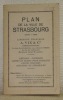
Reference : 73382
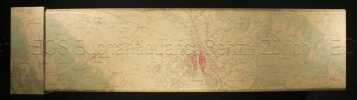
Plan de la ville de Strasbourg. Echelle 1 : 7500.
Strasbourg, A. Vix & Cie. sans date, vers 1945, 170x105mm, broché. Bel exemplaire.
Reference : 66758
Plans en relief de villes belges. Levés par des ingénieurs militaires français. XVIIe - XIXe siècle. Collection Histoire in-4°, n.° 1.
Bruxelles, Pro Civitate 1965, 320x260mm, 357pages, reliure d'éditeur sous jaquette. Exemplaire numéroté 295/1’050. Dechirures sur les deux coiffes de la jaquette et sur sont haut du plat supérieur, autrement bel exemplaire.
photos n/b,
Reference : 117645
PROFILO E TOPOGRAFIA DEL NUOVO PROGETTO DI FERROVIA MONZA-CALOLZIO PER LECCO.
Studiato per ordinanza del Municipio di Lecco dagli Ingegneri Bianchi e Crespi. Lit. degli Ingegneri, Milano, s.d. (1865 ca.). Pianta topografica (cm. 60x79,6), pi volte ripieg. Lievi aloni, altrimenti ben conservata.L'esigenza di congiungere Monza a Lecco spinse le istituzioni pubbliche e private a redigere diversi progetti, tre dei quali furono sottoposti nel 1864, all'attenzione del Consiglio provinciale di Milano. La scelta cadde su questo degli Ing. Bianchi e Crespi: prevedeva un tracciato che partendo da Monza, passava per Villa S. Fiorano quindi, fra Arcore e Oreno, giungeva alla Cascina Velasca, per poi attraversare l'Adda e raggiunge presso Calolzio la ferrovia LeccoBergamo gi esistente. Si unisce: Rapporto al Consiglio Provinciale di Milano della Commissione incaricata di riferire intorno alle domande state a lui dirette dalla detta Provincia un concorso nella spesa di Costruzione di una FERROVIA DA MONZA A LECCO. Milano, li 23 aprile 1864, in-8 p. (mm. 224x150), brossura muta, pp. 34. Ben conservato.
Reference : 16089
"Route Chart Illustrating Routes Described in H.O. Pub. No. 129"
"Sans lieu sans éditeur sans date (circa 1960) - Carte 47 cm x 78 cm- Texte en anglais - Carte des lignes maritimes au départ de Port of Spain (Trinidad et Tobago) et Willemstadt (Curaçao)- Très bon état"
Reference : 74723aaf
Schweizer Pioniere der Wirtschaft und Technik, Band 50: Eduard Imhof (1895 - 1986). Ein Leben mit Landkarten von Viola Imhof, Erlenbach ZH.
Meilen, Verein für wirtschaftshistorische Studien, 1990, gr. in-8°, 95 S., illustriert, broschiert.
Image disp.
(SLACES, NVVA)
Phone number : 41 (0)26 3223808
SOCIETE DES EXCURSIONNISTES MARSEILLAIS. Bulletin annuel. 16e année 1912.
Marseille Imprimerie Provençale 1913. In-8 broché 262pp 1 feuillet de table. Orné de 10 croquis dont 8 à pleine page et 1 hors texte, 1 fac simile de document, 4 cartes dépliantes hors texte dont 1 grande. Dos scotché, petite tache grasse ancienne (scotch)en tête du 1er plat de couverture, intérieur frais et complet.
Un bon reflet des activités de cette association: excursions de Briançon à Allos, le Massif de Carpiagne, le Massif de l'Etoile, Gap et la Montagne de Charance, excursion en Tunisie, en Alsace, en Auvergne... (3284)
SOCIETE DES EXCURSIONNISTES MARSEILLAIS. Bulletin annuel. 32e année 1928.
Marseille Imprimerie Provençale 1929. In-8 broché 214pp 1 feuillet de table. orné de 2 croquis hors texte et 4 cartes dépliantes. Coupure sans manque sur 1 carte avec trace grasse ancienne (scotch), intérieur frais et complet.
Un bon reflet des activités de cette association: travaux de la Société dans le massif de Marseilleveyre, jalonnement dans le Massif de l'Etoile, ascension de la Dent de Requin dans le Massif du Mont-Blanc... (3285)
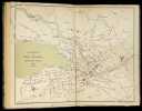
Topographische Aufnahme des Kantons Zürich von 1843 - 1851. Urheber: Geographisch Ethnografische Gesellschaft Zürich.
Masstab 1:25000 - Faksimileausgabe. Langnau am Albis. Dorfpresse Langnau. (1989). 14 gerollte Karten (mehrfarbig), 48 x 70 cm. In illustrierter Box. Deckelboden von Schachtel fehlt. Deckel oben mit Schadstellen. Sonst gutes Exemplar.
Zum 100-jährigen Bestehen der GEGZ herausgegeben. Dazu die Dokumentation von Arthur Dürst: "Die topographische Aufnahme des Kantons Zürich 1843-1851. Eine Dokumentation zur Faksimilierung der Originalzeichnungen. 40 Seiten mit zahlreichen Illustrationen. Ebenfalls herausgegeben von der Dorfpresse Langnau am Albis.
Reference : 129605aaf
Topographische Karte der Schweiz. 1:100 000. In 20 Blätter / Feuilles.
Bern, Eidg. Landestopographie, 1915 - 29, in-8° (gefaltet), vollständig in 20 numm. gef. Karten. Aufdruck auf Titel-Umschlag Planquadrat’, Orig. Pappschachtel mit Rückentitel.
Image disp.
(SLACES, NVVA)
Phone number : 41 (0)26 3223808
Uebersichtsplan der Gemeinde Schlieren.
Thalwil, Heinr. Müller, 1924. Blattformat: 71,5 x 102 cm.
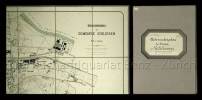
Gef. Karte auf Leinwand aufgezogen mit Grenzkolorit.
Reference : 144562
VEDUTA DEL DUOMO DI MILANO / VUE DE LA CATHEDRALE DE MILAN.
presso Antonio Bossi Negoz.e di Stampe Cont. de' tre Re N. 4091, Milano, 1830 ca. Bellissima veduta della Cattedrale incisa all'acquatinta da D. Landini (mm. 340 x 427 pi margini), sotto passe-partout. Molto ben conservata entro cornice in legno (mm. 520 x 686).
Verzeichniss der Höhen-Fixpunkte im Gebiete der Stadt Zürich. Herausgegeben vom Vermessungsamt der Stadt Zürich
Zürich, Museumsgesellschaft Zürich, 1895. 8°. 166 S., mit vielen ganzseitigen Abbildungen. Halbleinenband mit handschriftlichem Bibliotheks-Rückenschild.
Druck bei Hofer & Burger, Zürich. - Gut erhaltenes Exemplar.
Reference : 46520aaf
Zeitschrift des Deutschen und Österreichischen Alpenvereins. Beilage zu Bd. 21, Jg. 1890.
O.O. (Wien/Innsbruck/München), Vlg. des ZdD&OEAV, 1890, in-8vo, 1 gefalt. Karte + 6 Panoramen + 1 Kartenskizze + 1 Situationsplan + 17 Repro.-Abb. (alles aufgezogen auf Leinen) Hldr. - Schuber.
Enthält: 1) Special-Karte der Gross-Glockner-Gruppe, 1:50000. Zeichnung, Stich und Druck: Kartogr. Institut v. H. Petters, Hildburghausen.2) Siegl, Julius von: Rundschau vom Luschari-Berge. Drei fortlaufende Panoramen.3) Idem: Rundschau von der Plosse bei Brixen a.E. Drei fortlaufende Panoramen.4) Die Hauptkette der Karnischen Alpen. Kartenskizze.5) Grotten und Höhlen von St. Canzian bei Divaca (Triest). Situationsplan, aufgenommen und gezeichnet von A. Hanke. Lithographiert von Emil M. Engel. 6) 17 typographische Reproduktionen von Gestaltungskünstlern der Berglandschaft. U.a. Werke von A. Heilmann, Andreas Achenbach, Heinrich Heinlein, Franz Steinfeld, Adolf Obermüller, Friedrich Preller.Kaum bekannte und fast unauffindbare Beilage der Zeitschrift des Dt. und Österr. Alpenvereins.
(SLACES, NVVA)
Phone number : 41 (0)26 3223808
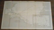
Reference : 5468
Îles Hiva-Oa, Tahuata et Motane. Plan levé en Janvier 1882 par M. M. Laurent Lieutnant de Vaisseau. Le Golleur, Barthe, Lauwick. Enseignes de Vaisseau. Sous la diretion de Mr. Ménard, Capitaine de Frégate. Commandant le Hugon. Service Hydrographique de la Marine, Paris, 1884.
s. l.(Paris), 1943 - 1950. 1 carte géographique 1050 x 740 mm, imprimé en noir et blanc, 1 correction (également imprimé) au format 179 x 220 mm collée, 1 tache de rousseurs sur la partie imprimée, plusieurs claires piqûres de rousseurs par ailleurs, traces de pli. Bon exemplaire.
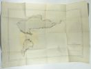
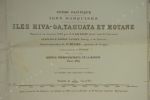
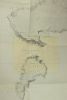
Le fond de carte a été levé en 1884, la carte a été rééditée en 1943, et pour cet exemplaire imprimée avec les corrections de 1948, une feuille collée, également imprimée, comporte les corrections de 1950. Envoi hors de France : le tarif économique est réservé aux livres d'un prix maximum de 50 euros. Dans tous les cas, le prix du port est calculé selon la destination et le poids du colis.
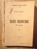
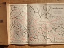
ARMEE DES ALPES / Guide de Secteur BASSE MAURIENNE ( Rive gauche ). ( Secret )
1940 1940 Edité par le Groupe de Canevas de Tir de l'Armée des Alpes. 1940. un guide de format in 8 de 144 pages avec une carte repliée. description de 56 passages ou cols des alpes de la Basse Maurienne. Exemplaire N° 229. Broché et agrafé. Nota: cette nouvelle édition présente quelques modifications, en regard de celle de 1939, dont la suppression des croquis et leur remplacement par une carte au 1/50.000 type 1922. tamponné " SECRET ". Rare. ref. col de la Croix-de-Fer, col de Fréjus, col de Fontaine Froide, col de Névache, col des Rochilles, passage du Pic du Thabor, etc.......
PROMOTION DE PRINTEMPS : REMISE IMMEDIATE DE 30% sur le prix affiché .
Géographie générale, classe de seconde (géographie physique, humaine et économique).
A.Hatier, collection Jean Brunhes, 1942, 427 pages, état d'usage, in 8 reliure éditeur cartonnée, dos toilé, quelques usures et frottements.
Le bestiaire de la Cathédrale d'Autun.
Editions Ange Michel (Lyon), 1973, environ 25 pages, brochure format in 8, bon état.
Les plus belles Cathédrales de France.
Alfred Mame et fils éditeurs, 1878, 347 pages, papier jauni, quelques rousseurs, bon état général, grand in 8 reliure éditeur cartonnée, percaline rouge ornée de motifs et décors en noir et or, titre et auteur lettrage or.
Louviers le Franc, ses églises, son musée.
Imprimerie de l'Eure, sans date, 128 pages, in 12 broché, état d'usage, coins cornés, coiffe supérieure frottée (mors légèrement fendus).
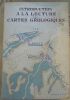
"Introduction à la Lecture des Cartes Géologiques"
"1962. Paris Éditions Masson & Cie 1962 3ème ed. 2ème tirage - Broché 17 cm x 25 cm 277 pages 103 figures in-texte et 8 planches hors-texte - Texte de A. Bonte préface de E. Raguin - Très bon état"
Cours de géographie (Chaulanges) cours élémentaires 1ere année.
1965 Librairie Delagrave 1965, exemplaire tamponé école des filles de St-Denis, 47 pages illustrations de Pierre Belves, cahier broché aux coins cornés au dos et charnières scotchés état moyen .
Le livre d'or du Dauphiné 1349-1949 (tome 2).
Roissard Grenoble, 1949, exemplaire non coupé, sur chifon de Rives numéroté N° 358/1350, 206 pages, in 8 broché, bon état.
Fra Mauro's Mappa mundi and Fifteenth-Century Venice / Terraum orbis 8
, brepols, 2011 Hardback. 470 pages ., 3 b/w ill. 16 colour ill., 210 x 270 mm, Languages: English, Terraum orbis 8 ISBN 9782503523781.
Fra Mauro's mappamundi, drawn around 1450 in the monastery of San Michele on Murano in the lagoon of Venice, is among the most relevant compendia of knowledge of the Earth and the Cosmos of the fifteenth century. By examining literary, visual, textual and archival evidences, some long considered lost, this book places the map within the larger context of Venetian culture in the fifteenth century. It provides a detailed analysis of both its main sources (auctores veteres such as Pliny, Solinus, Ptolemy, and novi, like Albert the Great, Thomas Aquinas, Marco Polo and Niccolo de? Conti) as well as of the composite networks of contemporary knowledge (scholasticism, humanism, monastic culture, as well as more technical skills such as marine cartography and mercantile practices), investigating the way they combine in the epistemological unity of the imago mundi. More a work on intellectual history than cartography, the book constructs a complex set of frameworks within which to situate Fra Mauro?s monumental effort. These range from the cultural history of the reception of the world map from the fifteenth to the nineteenth centuries to the analysis of the material conditions under which map-makers such as Fra Mauro worked; from the history of ideas, especially of natural philosophy to the links between world representations and travel literature. It also addresses the Venetian reception of Ptolemy?s Geography, the interactions between Venetian art, theology and cosmography and the complexities of the Venetian vernacular. The books develops a multi-tiered approach, in which different elements of the rich cultural context in which this world map was created, interact with each other, each casting a new light on the encyclopaedic work being analyzed.
Fra Mauro's Mappa mundi and Fifteenth-Century Venice
, Brepols - Harvey Miller, 2011 Hardcover. 470 p., 3 b/w ill. 16 colour ill., 210 x 270 mm, Languages: English, Including an index. Fine copy. ISBN 9782503523781.
Fra Mauro?s mappamundi, drawn around 1450 in the monastery of San Michele on Murano in the lagoon of Venice, is among the most relevant compendia of knowledge of the Earth and the Cosmos of the fifteenth century. By examining literary, visual, textual and archival evidences, some long considered lost, this book places the map within the larger context of Venetian culture in the fifteenth century. It provides a detailed analysis of both its main sources (auctores veteres such as Pliny, Solinus, Ptolemy, and novi, like Albert the Great, Thomas Aquinas, Marco Polo and Niccolo de? Conti) as well as of the composite networks of contemporary knowledge (scholasticism, humanism, monastic culture, as well as more technical skills such as marine cartography and mercantile practices), investigating the way they combine in the epistemological unity of the imago mundi. More a work on intellectual history than cartography, the book constructs a complex set of frameworks within which to situate Fra Mauro?s monumental effort. These range from the cultural history of the reception of the world map from the fifteenth to the nineteenth centuries to the analysis of the material conditions under which map-makers such as Fra Mauro worked; from the history of ideas, especially of natural philosophy to the links between world representations and travel literature. It also addresses the Venetian reception of Ptolemy?s Geography, the interactions between Venetian art, theology and cosmography and the complexities of the Venetian vernacular. The books develops a multi-tiered approach, in which different elements of the rich cultural context in which this world map was created, interact with each other, each casting a new light on the encyclopaedic work being analyzed. Angelo Cattaneo, who holds a Ph.D. in History from the European University Institute in Florence, is a researcher at the Centro de Historia de Alem-Mar of the Universidade Nova de Lisboa (Center for Overseas History of the New University of Lisbon). Currently he is studying the global circulation of knowledge, technology and material culture from the fifteenth to the seventeenth centuries, particularly cosmography, cartography and travel literature. He is the author of Mappa mundi 1457 (Rome, 2008). He also co-edited the volumes The Making of European Cartography (Florence, 2003) and, with Nathalie Bouloux and Patrick Gautier Dalche, Humanisme et decouvertes geographiques (Medievales 58, 2010).
Petit atlas élémentaire (A).
Chez Hachette, environ 1850 (non daté), 8 cartes dépliantes, in 8 reliure éditeur cartonnée, état d'usage, usures et couverture légèrement salie.