 Write to the booksellers
-
Type
Book (15695)
Engraving (1)
Magazine (27)
Maps (1)
Old papers (2)
-
Latest
Last 24h (10)
Last 3 days (48)
Last month (252)
Last week (14)
-
Language
Dutch (2)
English (25)
French (15697)
Greek (1)
Italian (1)
-
Century
16th (2)
17th (9)
18th (33)
19th (521)
20th (7058)
21st (3367)
-
Countries
Belgium (871)
Canada (11)
China (14)
Côte d'Ivoire (62)
France (14146)
Greece (2)
Italy (4)
Netherlands (6)
Switzerland (610)
-
Syndicate
ALAC (10)
CLAM (2)
CLAQ (1)
CNE (1)
ILAB (7793)
NVVA (438)
SLACES (438)
SLAM (7338)
SNCAO (10)
"Connaître l'Auvergne (Collection :""Villes et Régions"")"
Sud Ouest. Non daté. In-8. Broché. Bon état, Couv. convenable, Dos satisfaisant, Intérieur frais. 64 pages augmentées de nombreuses photos en couleurs dans et hors texte. Texte sur trois colonnes.. . . . Classification Dewey : 53-Guide
"Collection :""Villes et Régions"". Photographies de Régine Rosenthal Classification Dewey : 53-Guide"
Guide classique du voyageur en France,
avec une nomenclature étendue des Monuments druidiques, romains et du moyen-âge. Paris. Audin. 1835. In-12 (14x9). 500 pages. Demi-basane verte de l'époque, dos lisse orné de filets.
Aperçu de la France du début du 19° siècle. 18° édition. Grande carte itinéraire de la France (50 cmx 50) in fine et 3 plans dépliants : Rouen, Lyon, Bordeaux. Etat correct.
Guide classique du voyageur en France (24e édition, avec la carte routière générale, celle des chemins de fer et de la navigation à vapeur, et les plans des principales villes
Lib. de L. Maison. 1854. In-12. Broché. Etat d'usage, Couv. légèrement passée, Dos abîmé, Papier jauni. LXVII + 524 pages + 8 pages de catalogue - une carte et quelques plans en noir et blanc hors texte, planches dépliantes. Plats passés, 1er plat légèrement déchiré. Dos déchiré avec manques.. . . . Classification Dewey : 53-Guide
Classification Dewey : 53-Guide
Guide classique du voyageur en France avec la carte routière générale, celle des chemins de fer et de la navigation à vapeur et les plans des principales villes
Librairie de L. Maison. 1854. In-12. Relié. Bon état, Couv. convenable, Dos abîmé, Intérieur frais. 524 pages. Texte sur deux colonnes. Une carte dépliante en noir et blanc en fin d'ouvrage.. . . . Classification Dewey : 53-Guide
Classification Dewey : 53-Guide
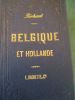
Guide Classique du voyageur en France & en Belgique.
MAISON L. 23ème édition. 1853. In-12. Relié demi-cuir. Etat du neuf, Couv. légèrement passée, Dos satisfaisant, Quelques rousseurs. 717 pages. 2 cartes dépliantes en noir et blanc hors-texte. Texte sur 2 colonnes. Titre doré sur le dos cuir vert. Epidermures sur le dos. Déchirure sur une carte. Manque une partie importante d'une 3ème carte, à la fin de l'ouvrage.. . . . Classification Dewey : 53-Guide
Chemins de Fers Français avec leur continuation par les Routes de Malle-Poste (1853). Carte Générale des Pyrénées, dressée par Dufour A. Voyage Pittoresque dans le Dauphiné et à la Grande Chartreuse Classification Dewey : 53-Guide
guide classique du voyageur en france et en belgique
paris l.maison 1854 in 12 relié pleine percaline 666 pages - index
avec la carte routiere, celle des chemins de fer et de la navigation à vapeur, plusieurs cartes spéciales et les plans des principales villes - 1 mors fendu
GUIDE DU VOYAGEUR EN FRANCE.
HACHETTE ET CIE. 1861. In-12. Relié toilé. Etat d'usage, Couv. convenable, Dos frotté, Quelques rousseurs. 667 pages aumgentées de quelques cartes de chemins de fer - Auteur, titre, Editeur et filet dorés.. . . . Classification Dewey : 53-Guide
Classification Dewey : 53-Guide
Guide du voyageur en France
Libraire de L. Hachette et Cie Relié 1866 In-12 (12 x 18 cm), reliure pleine toile, 830 + 112 pages, complet des 8 cartes ; importants frottements, traces et épidermures sur les plats et le dos, quelques traces aux gardes, état moyen. Livraison a domicile (La Poste) ou en Mondial Relay sur simple demande.
GUIDE DU VOYAGEUR EN FRANCE. 27 EM EDITION.
HACHETTE. COLLECTION DES GUIDES JOANNE.. 1873. In-12. Broché. Etat d'usage, Couv. légèrement passée, Coiffe en tête abîmée, Rousseurs. 1019 + 96 pages de publicités des guides Joanne. Contenant huit cartes des chemins de fer.. . . . Classification Dewey : 53-Guide
Classification Dewey : 53-Guide
GUIDE DU VOYAGEUR EN FRANCE. Comprenant la manière de voyager, les tableaux des routes, des relais, des communications, l'état général des postes, la description des villes, bourgs, villages, antiquités, monuments, établissements, ...
CHEZ AUDIN. 1828-1829. In-18. Relié demi-cuir. Etat d'usage, Coins frottés, Dos abîmé, Intérieur frais. 310 pages. Dos de cuir jaune, pièce de titres marron, titres fleuros et roulettes dorés. Papier multicolore sur les plats. Manque au dos partiellement détaché. Manque la carte routière.. . . . Classification Dewey : 53-Guide
...curiosités de la nature et de l'art, la notice des eaux minérales, la liste des diligences, voitures publiques, auberges, etc... Guide indispensable à l'artiste, à l'étranger et aux curieux. Classification Dewey : 53-Guide
GUIDE DU VOYAGEUR EN FRANCE - RESEAU DE L'OUEST - COLLECTION DES GUIDES-JOANNE
LIBRAIRIE HACHETTE. 1901. In-12. Relié. Etat d'usage, Couv. défraîchie, Dos satisfaisant, Intérieur acceptable. 156 + 43 + XX + 204 pages augmentées de nombreuse cartes et plans dépliants en noir et blanc et en couleurs - ex libris - texte sur 2 colonnes - auteur, titre et filets dorés sur le dos - ouvrage partiellement désolidarisé - coins émoussés - annotations au stylo sur la page de garde et page de faux titre. . . . Classification Dewey : 53-Guide
Classification Dewey : 53-Guide
GUIDE DU VOYAGEUR EN FRANCE - RESEAU PARIS-LYON-MEDITERRANEE - COLLECTION DES GUIDES JOANNE
LIBRAIRIE HACHETTE ET CIE. 1903. In-12. Relié. Etat d'usage, Coins frottés, Dos satisfaisant, Intérieur acceptable. 63 + XXVII + 228 + 18 + VI + 78 + 16 + VIII + 106 pages augmentées de nombreuses cartes dépliantes et plans en noir et blanc et monochrome - texte sur 2 colonnes - auteur, titre et tomaison dorés sur pièce de titre - filets dorés sur le dos - ex libris sur le 1er contre plat - une piqure de vers sur le dos - coins émoussés. . . . Classification Dewey : 53-Guide
Classification Dewey : 53-Guide
GUIDE DU VOYAGEUR EN FRANCE - - RESEAU PLM -Réseau Paris - Lyon - Méditerrannée,/ Collection des guides-Joanne
LIBRAIRIE HACHETTE & CIE. 1903. In-16. Broché. Etat d'usage, Couv. convenable, Dos satisfaisant, Intérieur frais. 136 Pages - Nombreuses Ilustrations, cartes dépliantes Noir et Blanc et Couleurs - Quelques annotations sur le contre plat, page de garde et page de sous tire au crayon. . . . Classification Dewey : 53-Guide
Réseau Paris - Lyon - Méditerrannée, 5 cartes et 27 plans Classification Dewey : 53-Guide
Guide du Voyageur en France. Réseau Paris-Lyon-Méditerranée.
P., Hachette - Collection des Guides Joanne, 1892 ; in-12, br. XIV-155pp.-34pp. (index)-132pp. (adresses utiles, publicités) - 5 cartes hors-texte dont 4 dépliantes en noir, et 24 plans hors-texte en couleurs. Couverture illustrée en couleurs. Bon état.
Guide du voyageur en Italie.
Itinéraire artistique, pittoresque, historique, commercial.RICHARD. Paris, L. Maison, 1851., In-12°, XL, 656 pp., 12 pp., demi chagrin noir filets frappés à froid sur les plats, tranches lisses. 1° D'amples renseignements sur la manière de voyager avec fruit et économie en Italie; 2° Les règlements et services des postes, des messageries, voitures, bateaux à vapeur et chemins de fer; 3° Les prix de transport et de séjour; 4° Le tarif comparé des monnaies, l'indication des hôtels et bains; 5° La description des villes, bourgs et villages que traverse le voyageur; 6° De longues notices sur les Musées, les monuments publics, les galeries particulières. Le tableau complet de Rome, Naples, Florence, Venise, Milan, Palerme, etc. La description de Pompéi et d'Herculanum. Orné d'une Carte routière de l'Italie, de la Carte de Sicile, de la Carte postale du Piémont, des Plans de diverses villes, du Panorama de Pompéi, du Plan du Siège de Rome, etc.
Ray I3*
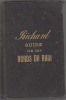
Guide du voyageur en Suisse.
Paris, Lib. de Audin - U. Canel, 1824. In-12 de L-[4]-718-[8] pages, demi-basane noire, dos lisse orné de filets dorés. Dos et plats griffés, mors et coiffes épidermés, accroc à la coiffe sup., quelques rousseurs.
Illustré de nombreuses vues.
guide pittoresque du voyageur en belgique itinéraire artistique industriel et manufacturier
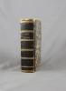
paris librairie de l. Maison éditeur des guides richard 1855 - In 12 pleine percaline éditeur XLIX-232 pages complet des plans et cartes dans le texte manque la carte routière en fin de volume
comprenant l indication des diverses routes de paris à bruxelles et les renseignements utiles aux voyageurs - le tableau comparatif des monnaies - les tableaux de routes les relais et distances d'un lieu à un autre - l itinéraire complet des chemins de fer et des bateaux à vapeur avec les prix des places - la description des villes villages hameaux bourgs chateaux et de tout ce qu ils renferment de curieux comme peintures monuments antiques et du moyen age ....
Manuel du Voyageur en Suisse. Comprenant: La descriptions des villes, villages, hamaux.... avec l’itinéraire complèt de la vallée de Chamouni, de l’Oberland, du pays de Grisons... Enrichi des cartes... Nouvelle édition,... revue et augm. de 300 articles nouveau. Suivi du Guide complet dans le Tyrol précédée d’un vocabulaire des différentes dialectes de la Suisse Allemande.
Paris, Maison, des Guides de Richard, 1845, pt. in-8vo, XXXI + 591 p. + 2 ff. (table - des routes & des Villes), ill. de 3 planches dépl: Carte de la Vallée de Chamouni / Thun et ses environs, avec 6 petites vues / Carte du Tyrol. (La Grande Carte de la Suisse par Keller manque), reliure en toile originale. Charnière devant légèrement usé.
(SLACES, NVVA)
Phone number : 41 (0)26 3223808
Manuel du Voyageur en Suisse. Le nouvel Ebel, revue, coordonné, mis en ordre et augmenté par Richard.. Suivi du Guide complet dans le Tyrol.
Paris, Maison, (1835). 105 X 180 mm. relié demi-chagrin marron, dos lisse avec titre et faux-nerfs dorés (rel. de l'ép.). XXXIX-660 pp. Avec 8 vues et 3 cartes. Reliure frottée avec dos restauré, détaché de l'ouvrage, rousseurs et mouillures.
Phone number : 41 021 964 60 10
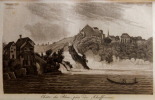
MANUEL DU VOYAGEUR SUR LES BORDS DU RHIN;- Itinéraire artistique, pittoresque et historique, comprenant la description des deux rives du Rhin de Mayence à Bâle; des villes, villages, hameaux, bourgs et châteaux que découvre le voyageur à bord du bateau à vapeur; d'amples notices sur Mayences, Cologne, Coblentz, Bonn, Francfort, etc.; de longs détails sur les ruines romaines, teutoniques et du moyen âge; des promenades de Manheim dans la Bavière rhénane, dans la Hesse, dans la vallée de la Nahe; de Heidelberg, par la Bergstrasse, à Darmstadt, au Taunus; de Cologne à Aix-la-Chapelle; une visite aux bains de Wiesbade, de Schwalbach, d'Ems; la déscription complète de Bade, de ses bains et de ses environs, de la vallée de la Murg et de la Forêt-Noire; l'indication des hôtels, des frais de séjour dans les villes et aux bains, des messageries, bateaux à vapeur;chemins de fer,ornée d'une belle carte routière,huitiéme édition, entiérement refondue par Richard.
1853 L Maison, libraire éditeur, Paris, 1853, in-12, percaline noire éditeur,XLIV, 619 + 36 + 7pp. Bien complet de la carte dépliante qui manque souvent. Vue de Bad-Ems gravé sur acier en front.Cartonnage et texte frais.
Remise de 20% pour toutes commandes supérieures à 200 €
LOUISIANE.
EDITIONS ULYSSES / GUIDE DE VOYAGE. 1995. In-8. Broché. Bon état, Couv. convenable, Dos satisfaisant, Intérieur frais. 409 pages. Premier plat illustré en couleurs. Quelques cartes en noir et blanc hors texte.. . . . Classification Dewey : 53-Guide
Classification Dewey : 53-Guide
Le guide de l'Aude
La manufacture. 1992. In-8. Broché. Bon état, Coins frottés, Dos satisfaisant, Intérieur acceptable. 292 pages. Rares rousseurs. Signet conservé. Deux colonnes de texte. Nombreuses photos en couleurs et en noir et blanc, in et hors texte.. . . . Classification Dewey : 53-Guide
Classification Dewey : 53-Guide
Indonésie. Collection : Les grands voyages.
Editions Centre Delta, 1978. 14 x 18, 319 pp., quelques illustrations et cartes, reliure moderne carton, très bon état.
Guide du Voyageur en France.
Hachette.1866.In-8,percaline éditeur.830 p.+ Appendice.96 p.Cartes.Etat correct avec piqùres.
Reisen in Deutschland - BAND III - Hessen (mitte und süd) - Saarland Rheinland-Pfalz Nordrhein-Westfalen --- Deutsches Handbuch für fremdenverkehr
Erwin Jaeger in8. Sans date. Cartonné. iconographie en noir et blanc
circa 1960 - couverture et tranche ternies intérieur globalement propre qques rousseurs par ailleurs