Write to the booksellers
-
Type
Book (557)
Engraving (1)
Magazine (19)
-
Latest
Last month (3)
Last week (1)
-
Language
English (1)
French (576)
-
Century
17th (1)
18th (25)
19th (141)
20th (298)
21st (13)
-
Countries
Belgium (25)
Côte d'Ivoire (1)
Denmark (335)
France (202)
Switzerland (14)
-
Syndicate
ILAB (385)
NVVA (3)
SLACES (3)
SLAM (46)
SNCAO (1)
Hedendaagsche Historie of, tegen woordige Staat van Groenland, en Straat Davids...Benevens eene uitvoerdige Beschryving, van de Walvisch-en Robben-Vangst: Met Plaaten en Kaarten. 3 vols. Amsterdam, W. Vermandel en J.W. Smit, 1786.
Uncut and partly unopened in 3 orig. printed boards. Backs and covers slightly rubbed. XXXIV,356,(2),282,(2),382,(2) pp. and 14 folded engraved plates (of which 2 are maps). Some sheets with browning to leaves.
Historia om Grönland, deruti Landet och dess Inbyggare ec. I Synnerhet Evangeliska Brödra=Församlingens däer warande Mission och dess Förrättningar I Ny=Herrnhut och Lichtenfels, beskrifwas 1.-2.Delen. 2 Bd.
Stockholm, 1769. 2 samt. hldrbd. med rygforgyldning og skindtitler. 1216 pp. samt 8 kobberstukne foldeplancher (heraf 2 kort).
Lauridsen II:Nr. 56. Første Svenske udgave. En fortsættelse udkom separat i 1770.
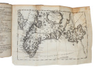
Historie van Groenland behelzende Eene nauwkeurige Beschrijvinge van s'Landsligging, gesteldheid, en naturlijke Zeldzooamheden den Aart, Zeden en Gewoonten der Inwoonern aan de West-Zijde de Straat Davis...3 Parts.
Haarlem, Amsterdam, 1767. Cont.hcalf. Extremities with traces of use. A small hole in back on titlelabel. XXXIV,356,282,382,(2) pp. and 14 fine fold. engraved plates (amonfg these 2 maps). Complete. - First Dutch edition. - Sabin 17415.
Historie von Grönland enthaltend die Beschreibung des Landes und der Einwohner ec. insbesondere die Geschichte der dortigen Mission der Evangelischen Brüder zu Neu=Herrnhut und Lichtenfels. Mit acht Kupfertafeln und einem Register.
Barby und Leipzig, Ebers/ Weidmanns Erben, 1765. Bound in a little later hcalf. Gilt spine. Gilt lettering. (34),1132,(26) pp., 2 folded engraved maps and 6 folded engraved plates. One plate with a closed tear, no loss. Light scattered brownspots and occassionally light browning.
First edition. - Lauridsen II,51. - Sabin, 17413.
Historie von Grönland enthaltend die Beschreibung des Landes und der Einwohner ec. insbesondere die Geschichte der dortigen Mission der Evangelischen Brüder zu Neu=Herrnhut und Lichtenfels. Zweyte Auflage. Mit acht Kupfertafeln und einem Register.
Barby und Leipzig, Ebers/ Weidmanns Erben, 1770. Bound in 3 contemp. hcalf. Gilt spines. Titlelabels with gilt lettering. Stamps on halftitle and parttitles. (38),1132,(26) pp., 2 folded engraved maps and 6 folded engraved plates. A few leaves with faint dampstaining.

Second edition. - Lauridsen II,51. - Sabin, 17413.
Le voyage de Crozet
1987 - broché - Sans mention d'édition - 1987 - In-8 (24 x 17 cm) broché - 132 pages - Illustrations en noir et blanc - Avec une carte volante - Titre complet : "Le voyage de Crozet en Tasmanie, en Nouvelle-Zélande, aux Îles Ladrones, aux Philippines. 1771 - 1772. A la découverte des îles Crozet." - Préfaces de Joseph Crozet et Jas. R. Boosé - Avant propos et post-face de Hélène Roux - A PROPOS : Édition établie d'après la traduction anglaise de H. Ling Roth (1891), le manuscrit français original étant perdu. Hélène Roux reconstitue le texte à partir des notes de voyage de Julien Crozet, navigateur et explorateur français du XVIIIe siècle. Ce récit constitue l'un des principaux témoignages sur l'expédition de Marion Dufresne (1771-1772), la découverte des îles Crozet, les premières observations des Terres australes et les escales en Tasmanie, en Nouvelle-Zélande, aux îles Ladrones et aux Philippines.


Bon état
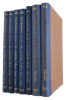
Danmark-Ekspeditionen til Grønlands Nordøstkyst 1906-1908 under Ledelse af L. Mylius Erichsen. 6 Bd. (i 10 afdelinger, komplet).
Copenhagen, 1913-17. Lex8vo. Alle 10 dele i orig. bogtrykte omslag, ubeskåret og uopskåret. 474,516,39,346,286,175,320,236,436,387 pp., tekstillustrationer, 4 portrætter, 153 plancher og 1 kort.
Fist edition of the largest expedition ever undertaken to North-East Greenland. - ""The year 1908 will always remain a memorable year in the history of Greenland's exploration. With the return of the Denmark Expedition and the news of the magnificent results achieved by the Expedition, the coping stone was laid on a work, which had engaged the unwearied attention of numerous explorers for centuries. The last wide stretch of unknown coast on the north-east of Greenland had been investigated and surveyed by this Expedition and the extensive coast line of Greenland was now known in the whole of its lenght."" (G. Amdrup). - Meddelelser om Grønland, Bd. 41-46.
Danmark-Ekspeditionen til Grønlands Nordøstkyst 1906-1908 under Ledelse af L. Mylius-Erichsen. First Part. Contributions by G. Amdrup, Alf Trolle, H.A. Bistrup, J. Lindhard, G.C. Amdrup).
København, Reitzel, 1913. Royal8vo. Orig. printed frontwrapper. Small nick to wrapper and spine. Uncut. 474 pp., 24 plates, 4 portraits, textillustr. Internally clean and fine. Text in English.
First edition of the scientific results from the famous Denmark-Expedition, the first volume only. - Meddelelser om Grønland, Vol. 41.
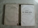
Le pôle sud
Paris, Hachette 1889 311pp., illustré de 53 vignettes, dans la série "Bibliothèque des merveilles", 18cm., reliure moderne, cachet, qqs. rousseurs, bon état, A106658
To the Rescue of the Nobile Expedition by Gerard De Geer June 1928. With 2 maps and 1 plate.
Stockholm, Kartografisk Sällskapet, 1928. 4to. In contemporary half cloth with front wrapper pasted on to front board. Stamp to pasted down front free end-paper and stamps to title-page. 1 pp + folded map.
First edition.
Les conquérants de l'Antarctique
Librairie Arthème Fayard Paris, 1956, in-8 demi-chagrin caramel, dos à quatre nerfs, premier plat de couverture conservé. 259pp.-2ff. Très bon état.

Indeholder N. Hartz' Botaniske Rejseberetning fra Vestgrønland 1889 og 1890 samt bidrag af L. Kolderup Rosenvinge, E. Østrup, E. Cohen, C. Jensen, J. Hagen.
Kjøbenhavn, Reitzel, 1898. Ubeskåret og uopskåret i orig. bogtrykt omslag. (6),464 pp., tekstillustrationer og 2 plancher.
(Meddelelser om Grønland, bd. 15).
DEN II. THULE EXPEDITION - II. THULE-EXPEDITION. - KNUD RASMUSSEN & LAUGE KOCH.
Reference : 50893
(1928)
Report of the II. Thule-Expedition for the Exploration of Greenland from Melville Bay to De Long Fjord by Knud Rasmussen. 1927. (+) Contributions to the Glaciology of North Greenland by Lauge Koch. 1928. (2 parts).
København, Reitzel, 1928. Royal8vo. With orig. printed frontwrapper. Spine gone. Sewing a bit loose. (6),464 pp., 3 maps (2 large and folded), 6 plates, many photographic illustrations in the text. Small stamp on foot of wrapper and halftitle. Uncut and internally fine and clean.
First edition of the report of the famous Second Thule Expedition which brought back importent geographical and geological informations of the fjords, especially Independence Fjord. - Meddelelser om Grønland, Bd.65.
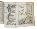
[Beautemps-Beaupré] - DENTRECASTEAUX (Antoine-Raymond-Joseph de Bruny) , ROSSEL (Édouard de)
Reference : PHO-1
(1807)
Voyage de Dentrecasteaux, envoyé à la recherche de La Pérouse. Publié par ordre de sa Majesté l’Empereur et Roi, sous le ministère de S. E. le vice-amiral Decrès, comte de l’Empire. Rédigé par M. de (Édouard de) Rossel, ancien capitaine de vaisseau.
A Paris, Dépôt général des Cartes et Plans de la Marine et des Colonies, 1807 et De L’Imprimerie Impériale, 1808 RARE ENSEMBLE COMPLET en 3 volumes TEXTE ; 2 forts vol. in-4° ; (2)-LVI-704 pp.-32 pl. h.-t. repliées in-fine (I-XXXII)/(2)-VIII-692 pp.-1 pl. h.-t. Repliée sur papier bleuté , relié demi cuir , dos lisse avec titre et tomaison , tranches mouchetées , mouillure angulaire sur 7 planches, petites rousseurs sur les planches . ATLAS ; 1 volume grand in-folio (560x445) ,page de titre-1 fnch. (Table )-39 cartes et vues h.-t. , dont 29 à double page ,dressées par l'ingénieur hydrographe C. F. Beautemps Beaupré et gravées sur cuivre par E. Collin , relié demi cuir , dos lisse ,cachets répétés , petites rousseurs .
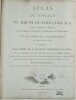
Édition originale de la relation du voyage de Bruny d'Entrecasteaux, envoyé par Louis XVI en Océanie à la recherche de La Pérouse. Sa rédaction a été confiée au capitaine de vaisseau Rossel, qui s'est appuyé sur le journal laissé par d'Entrecasteaux, emporté par le scorbut au cours du trajet. Elle est illustrée de 33 planches dépliantes dans les volumes de texte et de 39 cartes et vues dans l’atlas , réalisées pendant l'expédition et qui étaient d'un niveau exceptionnellement élevé, en particuliers les 12 magnifiques cartes de l'Australie occidentale et de la Tasmanie qui enregistraient la côte avec précision pour la première fois , la nouvelle méthode de Beautemps-Beaupré , révolutionna la cartographie . En février 1791, inquiet du sort de l'expédition commandée par La Pérouse, qui aurait dû être rentrée en France depuis plusieurs mois, Louis XVI fit envoyer deux frégates à sa recherche, symboliquement rebaptisées La Recherche et L'Espérance. Cette ambitieuse expédition quitta Brest en septembre, doubla le cap de Bonne-Espérance, visita plusieurs îles du Pacifique sud (la Tasmanie, la Nouvelle-Zélande, la Nouvelle-Calédonie, les îles Tonga, le Vanuatu, etc.) et se termina de façon chaotique à Sourabaya, un des principaux établissements hollandais situés sur l'île de Java. L'équipage y arriva diminué par la fatigue et la maladie , alors que la France avait changé de régime et était en guerre avec l’Angleterre, sans avoir trouvé la moindre trace de La Pérouse. Hormis son issue malheureuse, l'expédition fit des découvertes importantes dans le domaine de la géographie, de l'hydrographie et des sciences naturelles, et rapporta une liste de vocabulaires des peuples qu'elle rencontra (voir les pages 557-590 du premier volume). UN RÉCIT TRÈS RARE D'UN VOYAGE D'UNE IMPORTANCE ÉNORME POUR L'EXPLORATION DE L'AUSTRALIE ET DU PACIFIQUE Antoine Reymond Joseph de Bruni d'Entrecasteaux, dit le « chevalier d'Entrecasteaux » , entre dans la marine à l’age de 15 ans , combattit à Minorque , accompagna Chabert dans ses expéditions scientifique , prend le commandement de la flotte française dans l’océan indien , ouvre une nouvelle route de navigation vers la Chine , il devient gouverneur des Mascareignes jusqu’à sa nomination à la direction de l’expédition à la recherche de La Pérouse en 1791. Charles-François Beautemps-Beaupré, (Neuville-au-Pont 1766, Paris 1854), est un ingénieur hydrographe et cartographe français, membre de l'Académie des sciences et du Bureau des longitudes . Il est considéré comme le père de l'hydrographie moderne . Chadenat, n°5056. , Sabin, n°22671 FIRST EDITION. D'Entrecasteaux joined the French navy in 1754 and fought in 1756 at Minorca. He assumed command of the French fleet of the East Indies and in 1787, was appointed governor of Mauritius and the Isle of Bourbon. While in command in search for La Perouse in 1791-92, he determined the position of Amsterdam Island, explored the coastlines of New Caledonia, Tasmania, and New Holland, and located several groups of islands. Many of the charts made by the expedition (particularly those of South Australia produced by Beautemp Beaupre) were of unusually high standards, and the 12 magnificent maps of Western Australia and Tasmania recorded the coast accurately for the first time. They are regarded the most significant ever made. A VERY RARE ACCOUNT OF A VOYAGE WITH TREMENDOUS IMPORTANCE TO THE EXPLORATION OF AUSTRALIA AND THE PACIFIC
DEN ØSTGRØNLANDSKE EXPEDITION 1891-92 - THE RYDER-EXPEDITION.
Reference : 31933
(1895)
Den østgrønlandske Expedition, udført i Aarene 1891-92 under Ledelse af C. Ryder. 1.-3. Del (3 Bd., komplet).
København, 1895-96. Alle 3 bind i originale bogtrykte omslag, ubeskårede og uopskårede. Omslagene lettere falmede og med et par smårifter, ellers aldeles frisk eksemplar. (8),374(8),513(8),272 pp., talrige tekstillustrationer, 40 plancher, heriblandt farvelitograferede plancher, kort m.v.
First edition of one of the first scientific expedition to Greenland lead by The Greenlandic Commission. It contains the first scientific survey of the huge areas around Scoresby Sound. (Meddelelser om Grønland, Bind 17-19).
Das Nord-Polarmeer. Nach Tagebüchern und Aufnahmen während der Reise mit Sr. Maj. Schiff ""Olga"". Herausgegeben vom Deutschen Seefischerei-Verein.
Hannover und Leipzig, Hahn'sche Buchhandlung, 1901. Orig. pictorial full cloth. Name on title-page and a stamp on half-title. XVI,361 pp., textillustrations and coloured maps. Clean and fine.
The State of the Ice in the Arctic seas and the surface-temperatur of the sea in the northern Atlantic-Ocean and in Davis-Strait 1893-1930. The general title alternates a bit in the beginning and the first years bear the title ""Storisen i Davis-Stræd... - [THE FIRST COOPERATIVE AND SYSTEMATIZED MONITORING OF THE ARCTIC SEA ICE]
(Copenhagen, DMI, 1893-1930). Small folio. The issues 1893-1915 are all bound with all the original printed wrappers (stating that they are off-prints) for every issue (except for the front wrapper for the first issue) in four near contemporary blue half cloth bindings with gilt titles and years to spine. The issues 1916-1930 are all present in the original printed wrappers and housed in three custom-made slipcases identical to the four preceding volumes. Ste back wrapper of the 1924-issue is loose. Otherwise the set is generally in excellent condition, with stamps from the Danish Meteorological Institute, in the holdings of which it has been until the present day. With numerous charts and maps throughout.
Scarce run of the important first Arctic Sea Ice Charts from the Danish Meteorological Institute, all in off-prints from the Meteorological Year Books of Danish Meteorological Institute, constituting a continuous run, from its very beginning in 1893, of the first 38 years. These earliest Arctic Sea ice measurements and charts are absolutely fundamental for the monitoring of sea ice and, for our ability to determine the extent of the acceleration of global warming, and for the possibility of potentially changing climate patterns. ""...the maps from the Danish Meteorological Institute. These are remarkable for their information value and because they represent a cooperative international effort to report ice conditions in a systematic way that was sustained over decades."" (Florence Fetterer: Piecing together the Arctic's sea ice history back to 1850, in: Carbon Brief). ""These charts, created by the Danish Meteorological Institute (DMI), provide observed and inferred sea ice extent for each summer month from 1893 to 1956. From 1893 to 1956, the Danish Meteorological Institute (DMI) created charts of observed and inferred sea ice extent for each summer month. These charts are based on compiled observations of ice conditions reported by a variable network of national organizations, shore-based observers, scientific expeditions, and ships as detailed in each report"" in cases where no observations were available, the lead mapmakers extrapolated further ice cover using their knowledge of ice movement."" (DMI - Danish Meteorological Institute). The early surveillance of the Arctic Sea Ice has been of immense importance to the development of climate change science. It is the cause of the determination of global warming and the primary proof we have of the deterioration of sea ice, the heating of the oceans and the rice of Arctic temperatures. These seminal charts constitute one of the very most important sources to our understanding of this world-threatening phenomenon. ""Over the last three centuries, geographers, oceanographers, geophysicists, glaciologists, climatologists, and geoengineers have shown great interest in Arctic Ocean sea ice extent. Many of these experts envisaged an ice-free Arctic Ocean. This article studies three stages of that narrative: the belief in an ice-free Arctic Ocean, the potential for one, and the threat of one. Eighteenth and nineteenth century interest in accessing navigable polar sea routes energised the belief in an iceless polar sea" an early twentieth century North Hemispheric warm spell combined with mid-century cold war geostrategy to open the potential for drastic sea ice loss" and, most recently, climate models have illuminated the threat of a seasonally ice-free future, igniting widespread concerns about the impact this might have on Earth's natural and physical systems. This long narrative of an ice-free Arctic Ocean can help to explain modern-day scepticism of human-induced environmental change in the far north."" (An ice-free Arctic Ocean: history, science, and skepticism).
AU PÔLE ANTARCTIQUE
ERNEST FLAMMARION, PARIS, 1932. Ernest Flammarion éditeur, Paris, S.D. (vers 1905). Edition Originale française. IX + 403p. f. in-8 sous reliure e demi-cuir marron avec quatre nerfs. 105 illustrations in texte la plupart pleine page, cartes .
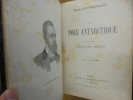
Très bon état général pour un exemplaire quasi centenaire. Intérieur frais et agréable, extérieur propre, bon exemplaire de collection ou documentation.
LE "CHARCOT" ET LA TERRE ADELIE
1951 broché (paperback) in-octavo sous jaquette illustrée (with dustjacket illustrated), tranches non rognées (edges no smooth), illustrations hors-texte (full page engraving), 303 pages, 1951 à Paris Editions France-Empire,
bon état général (very good condition)
Croisière océanographique accomplie a bord de la Belgica dans la Mer du Grönland 1905. Résultats scientifiques.
Bruxelles, Charles Bulens, 1907. Large 4to. Orig. hcalf. Spine and upper cover with gilt lettering. Spine loose with heavy wear and nicks. Frontcover detached from spine. Stamp on title-page. Frontispiece. 567,(3),V pp. and 80 plates, maps etc. Internally clean and fine.
Croisière océanographique accomplie a bord de la Belgica dans la Mer du Grönland 1905. Résultats scientifiques.
Bruxelles, Charles Bulens, 1907. Large 4to. Orig. hcalf. Spine and upper cover with gilt lettering. Wear to spine ends. Tears to upper part of spine and some cracking to part of joint. Stamp on title-page. Frontispiece. 567,(3),V pp. and 80 plates, maps etc. Internally clean and fine.
Opération Deepfreeze, expédition américaine dans lAntarctique.
Paris, René Julliard, 1957, collection la croix du sud, 14x19 cm, broché , couverture à rabats illustrée, 223 pages, préface de Paul-Emile Victor, 8 cartes et 9 illustrations.
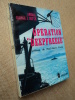
Marques de pliure sur dos (voir photo)
"Opération ""Deepfreeze"", expédition américaine dans l'Antarctique."
Paris, Julliard, 1958. 14 x 19, 228 pp., 8 cartes, 9 illustrations, broché, non coupé, bon état.
Préface de Paul-Emile Victor.
VOYAGE AU POLE SUD ET DANS L'OCEANIE sur les corvettes L'Astrolabe et la Zélée exécuté par ordre du Roi pendant les années 1837,1838, 1839, 1840. HISTOIRE DU VOYAGE TOMES IX ET X SEULS réunis en 1 volume.
paris Gide 1846. 2 tomes en 1 volume in-8 362pp dont table et 318pp 1 feuillet non chiffré table. Demi basane brune, dos lisse orné de quatre filets dorés en place des nerfs, reliure de l'époque. Auréoles anciennes et papier légèrement bruni. Chaque volume, complet de toutes ses pages, est solidaire de la reliure mais les coutures se sont cassées entre les deux. Reliure typique de l'époque en bon état. (5096)
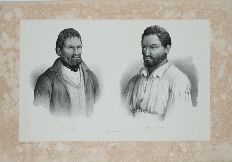
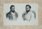
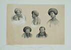
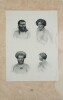
[Ernest Goupil] - DUMONT d’URVILLE , GOUPIL (Ernest , dessinateur)
Reference : PHO-1247
Voyage au pôle Sud et dans l'Océanie
Ensemble de cinq planches: -(PL87) La reine de Pao - femme et jeune fille de Pao -(PL47) Makima Itou-Routa ( Iles Manga-Reva) -(PL117) Naturels de la Baie Raffles -(PL46) Mama-Houi Tima-Temouo Iles Maga-Reva -(PL86) Naturels de PAo et de Lebouka Gide éditeur, imprimé par Lemercier à Paris.Timbre sec Gide éditeur Dessiné par Goupil, Lith par Bayot 55 X 36 cm Quelques petites rousseurs en marge , mouillures et multiple déchirures en bordure .