Write to the booksellers
3 books for « sebastian munster 148... »Edit
-
Type
Book (2)
Engraving (1)
-
Language
French (2)
German (1)
-
Topics
Geneva (1)
Helvética (1)
Travel (1)
-
Countries
France (1)
Greece (1)
Switzerland (1)
-
Syndicate
ILAB (2)
NVVA (1)
SLACES (1)
Suisse centrale p. 67, (GRIMSEL, SOLOTHURN, LUZERN, SITTEN, CHUR, BODEN SEE etc)
du (Cosmographey oder beschreibung aller Länder herrschafften)... "Die erst Tafel innhaltend das Schweytzerlandt mit den anstossnden Laendern" Gravure sur bois 26 x 34 cm, manque une partie du cote droit.
Phone number : 00 30 210 3616330
Double page (p. 98/99) woodcut view of Geneva from Sebastian Münster's famous "Cosmographia". Civitas Genevensis apud allobroges populos... " Clarissiniæ civitatis Genevensis situs & figuratio, latusque eius meridianum..
Basileae Henricum Petri, 1552, 15.5x35.5 cm (Vue), original Handcolored copy; Latin title to verso / Vue de Genève gravés sur bois, sur 2 feuilles, coloriés d’époque, Feuille N° 98/99. 1 feuille 32x40 cm.
The woodcut view shows the city from across Lake Geneva/ Lac Léman with the covered bridge joining the two parts of the city.Coat of arms to upper left corner ; text below. Good dark impression; minor show through of text from verso; small hole to upper and lower margin from binding; light spotting to centre of view & light damp stain to lower blank margin, below text; lower centre fold split, repaired to verso; old ink under linings and corrections to text image disp.
(SLACES, NVVA)
Phone number : 41 (0)26 3223808
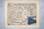
POLONIAE ET UNGARIAE TABULA.
CIRCA 1540-1560. BELLE CARTE GEOGRAPHIQUE (34,5 X 27 CENTIMETRES ENVIRON, 32,5 X 41 AVEC LES MARGES) DE LA POLOGNE ET DE LA HONGRIE, GRAVEE SUR BOIS ET COLORIEE A LA MAIN D'EPOQUE. PROVIENT DE LA VERSION PAR MUNSTER DE LA "GEOGRAPHIA UNIVERSALIS" D'APRES PTOLEMEE, QUI CONNUT PLUSIEURS EDITIONS EN PLUSIEURS LANGUES ENTRE 1540 ET 1560, CELLE-CI AVEC LE TEXTE LATIN AU DOS ET PORTANT LE NUMERO 16. TRES BEL ETAT.