 Write to the booksellers
3 books for « rigobert bonne 1727 1... »Edit
-
Topics
Africa (2)
Egypt (1)
ETATS DU ROI DE MAROC LES ROYAUMES D'ALGER DE TUNIS ET DE TRIPOLI AVEC LES PAYS CIRCONVOISINS
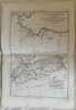
Mappa del 1780 circa del nord Africa (odierno Marocco, Algeria, Tunisia, Libia) di Rigobert Bonne.<BR> AUTORE: Rigobert Bonne (1727-1755), André TECNICA: acquaforte su acciaio DIMENSIONI FOGLIO: 42x29 cm DIMENSIONI INCISIONE: 36x24,5 cm EPOCA: 1780 circa CONDIZIONI: buone condizioni. Piegatura orizzontale. Nice map by Rigobert Bonne featuring North Africa countries (modern-day Morocco, Algeria, Tunisia, Lybia). Author: Rigobert Bonne (1727-1755), André Date: 1780 circa Technique: etching on steelLeaf Dimension: 42x29 cm Engraving Dimension: 36x24,5 cm Conditions: Good conditions. Horizontal foldings.<BR><BR>
ROYAUMES ETATS ET PAYS DE LA HAUTE GUINEE
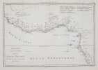
Mappa originale di Rigobert Bonne che raffigura il Golfo di Guinea, antico Regno della Guinea Superiore. AUTORE: Rigobert Bonne (1727-1755), André DATA: 1780 circa TECNICA: incisione su acciaio DIMENSIONI FOGLIO: 29x42 cm DIMENSIONI INCISIONE: 25x36,5 cm CONDIZIONI: Buone condizioni. Piegatura verticale. Piccol gora d'umidità all'angolo superiore destro<BR> Map by Rigobert Bonne featuring the Gulf of Guinea, former reigns of Upper Guinea (modern-day Senegal, Guinea, Sierra Leone, Liberia, Cote DIvoire, Ghana, Togo, Benin, Nigeria, Cameroon, Gabon, Congo, Angola). Author: Rigobert Bonne (1727-1755), André Date: 1780 circa Technique: etching on steel Leaf Dimension: 29x42 cm (11.4x16.5 inches) Engravin Dimension: 25x36,5 cm (9.8x14.4 inches) Conditions: Good conditions. Vertical folding. Little water stain in the upper right corner.
EGYPTE, NUBIE ET ABISSINIE
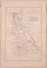
Mappa di Rigobert Bonne che mostra le coste dell'Egitto, Nubia and Abissinia (Egitto, Sudan ed Etiopia). Autore: Rigobert Bonne (1727-1755), André Data: 1780 circa Tecnica: incisione su rame Dimensione foglio: 42x29 cm Dimensione dell'incisione: 34x23 cm Condizioni: buone. Piegatura orizzontaleMap by Rigobert Bonne featuring the coasts of the Egypt, Nubia and Abissinia (modern-day Egypt, Sudan and Aethiopia). Author: Rigobert Bonne (1727-1755), André Date: 1780 circa Technique: copper engraving Leaf Dimension: 42x29 cm (16.5x11.4 inches) Engraving Dimension: 34x23 cm (13.4x9.1 inches) Conditions: Good conditions. Horizontal folding.