 Write to the booksellers
1 books for « quadt matthias »Edit
Fasciculus geographicus complectens praecipuarum totius orbis regionum tabulas circiter centum, una cum earundem enarrationibus.
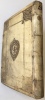
Cologne, Johann Bussemecher, 1608. 1608 1 vol. in-folio (272 x 203 mm) de : [4] ff. doubles montés sur onglets (titre, dédicace, préface, table), 85 cartes sur double page montées sur onglet avec texte au verso et 2 à pleine page, [2] ff. Doubles pages montées sur onglet et [1] f. (tables et index). Cartes en coloris d'époque. Plein vélin estampé d'époque, double encadrement avec frise sur les plats et blason de la justice au centre, traces de titrage à l'encre au dos, traces de lacets (reliure allemande). (Restaurations anciennes aux dos, aux coins et au titre, salissures, quelques feuillets de texte legerement roussis).
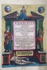
Troisième et dernière version, augmentée, de l'atlas de Quadt, contenant 6 cartes relatives aux Amériques. Matthias Quadt (1557-1613) était un contemporain plus jeune de Mercator, Ortelius et Eitzing. Comme Mercator, il était l'un des rares à être capable de graver ses propres cartes. La version originale, « Europae totius terrarum orbis partis praestantissimae », a été imprimée en 1596 avec 67 cartes. En 1600 Quadt a publié une version augmentée avec 15 nouvelles cartes sous le titre « Geographisch Handbuch ». Le présent ouvrage est encore augmenté de 5 nouvelles cartes: la numéro 4 (Barbaria), la 32 (Thuringe), le 34 (Lunaeburgensis Ducatus), la 64b (Neopolitanum Regnum) et la 65 (Mediolanensis Ducatus). Toutes sont inspirées d'Ortelius, comme la page de titre, qui est tirée de la même planche que le titre du « Geographisch Handbuch. « Une autre école florissante de cartographie a été centrée à Cologne, les travaux de Braun et Hogenberg, Quad et Vopel ajoutant un lustre à sa renommée » (Tooley). Provenance: Lord Wardington (ex-libris au dos du premier plat). Bel exemplaire, joliment reliée et en coloris d'époque très frais. Phillips 4253a. Tooley, p. 25-26. 1 vol. in-folio (272 x 203 mm) of : [4] double tabbed ff. (title, dedication, preface, table), 85 double-page tabbed maps with text on verso and 2 full-page, [2] ff. Double-page mitered and [1] f. (tables and index). Maps in period colors. Contemp. stamped vellum, double frame with frieze on the covers and coat of arms of justice in the center, traces of titling in ink on the spine, traces of laces (German binding). (Old restorations to the spine, corners and title, dirt, some slightly scorched leaves of text). Third and final version of Matthias Quadt's printed atlas, containing 6 maps related to the Americas. Matthias Quadt was a younger contemporary of Mercator, Ortelius, and Eitzing, and like Mercator was one of the few who was able to engrave his own maps. The original version, Europae totius terrarum orbis partis praestantissimae, was printed in 1596 with 67 maps. In 1600 Quadt issued an augmented version with fifteen new maps under the title Geographisch Handbuch. The present work is again augmented with five new maps: number 4 (Barbaria), 32 (Thuringia), 34 (Lunaeburgensis Ducatus), 64b (Neopolitanum Regnum) and 65 (Mediolanensis Ducatus). All are based on Ortelius, as is the title-page, which is from the same plate as the title in the Geographisch Handbuch. Another flourishing school of cartography was centered in Cologne, the works of Braun and Hogenberg, Quad and Vopel adding a lustre to its fame (Tooley). In 1592 the engraver Matthias Quad had his first quarto atlas, Europae Descriptio, published in Cologne by Johann Bussemacher. This atlas of Europe contained 50-54 maps, and was republished in 1594 and 1596. A few years later it was expanded to cover the whole world, and published in 1600 as Geographisch Handtbuch, with 82 maps, and in 1608 as Fasciculus Geographicus, with 86 maps. Fine copy, nicely bound and in original colors.
Phone number : 06 81 35 73 35