Write to the booksellers
7 books for « lowenorn p poul de »Edit
-
Century
18th (5)
19th (2)
-
Topics
Maps (1)
Technology (1)
Beskrivelse over et Nyt, sparsommeligt Fyhr med syderal Lampe, anbragt paa Knudshoved ved Nyborg 1822 tilligemed Anvendelsen af syderal-rever-berer til en ny Characteristik af Blink eller omkringstaaende Fyhre.
(København, H.F. Popps), 1823. 4to Uden omslag, ubeskåret som udgivet i særtryk i Videnskabernes Selskabs Skrifter. 12 pp. samt en kobberstukket akvatinteplanche. Trykt på skrivepapir.
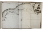
Beretning om et forbedret Kaart over de Hetlandske Öer, tilligemed trende Blade med Landtoninger og et speciel Kaart over Valley-Sund paa Hetland. Udgivet fra det Kongelige Söe-Kaarte-Archiv 1787. (Description of a new improved chart of the Islands of...
Kiöbenhavn, Thiele, 1787. 4to. Originale blåmarmorerede omslag. Stempel på titelbladet. 16 pp., 4 kobberstukne plancher (3 foldede med landtoninger samt et kort). Rent velbevaret eksemplar på skrivepapir.
First edition. The work appeared the same year in English. - Bibl. Danica II,358.
"SAN MIGUEL, DON VICENTE TOFINO DE. (+) [translated and written by:] POUL DE LÖWENÖRN.
Reference : 58844
(1792)
Beskrivelse over den Spanske Kyst i Middelhavet og den Deel af Kysten af Afrika beliggende lige overfor til Oplysning og Brug ved de derover efter den Kongelige Befaling i Spanien [i.e. English: ""Description of the Spanish Mediterranean coast and the...
[No place], 1792 & 1793. Folio. 2 volumes. Vol. 1 (1792) in a bit later half calf with five rasied bands and gilt lettering to spine. Vol. 2 in a later full sprinkled calf with five raised bands and with gilt lettering and gilt stamp to spine. Small paper-label pasted on to pasted down front end-papers and stamp to first front free end-paper and two stamps to title-pages. Light wear to extremities. Written of thick paper. Fine and clean. LLII, 277, (3) pp. XVII, 291, (4) pp.

Danish manuscript translation of Tofino's famous description of the Spanish Mediterranean coast. ""Vincente Tofiño was a rear-admiral in the Spanish navy. He was a renowned astronomer and mathematician and near the close of his career was the King’s hydrographer. Between 1783-1788, Tofiño charted the ports and coasts of Spain as well as the shore of North Africa. He eventually was elected as correspondent of the Spanish Academy of History and of the French and Portuguese Academies of Sciences."" Translator De Løwenørn (Kommandør-Kaptajn Friderich de Løwenørn) n 1784, captain lieutenant Poul de Løwenørn assisted the Danish crown in establishing the Royal Danish Nautical Chart Archive. He was appointed the institution’s first Director. At this time, only France had a similar institute.""In the first instance, the Danish Admirality requested Løwenørn to collect all existing nautical charts and navigational details in the country, for both Danish and international waters. He was to develop accurate and reliable charts for both the Navy and Merchant Marine.In addition to these formidable tasks, Løwenørn also took the initiative to establish a Lighthouse Authority, a Buoy Authority and a Pilot Authority as well as improve the country’s harbours."" (Danish Geodata Agency).Hansen, Sources of the History of North Africa, Asia and Oceania in Denmark, p. 459.
"SAN MIGUEL, DON VICENTE TOFINO DE. (+) [translated and written by:] POUL DE LÖWENÖRN.
Reference : 58880
(1792)
Beskrivelse over den Spanske Kyst i Middelhavet og den Deel af Kysten af Afrika beliggende lige overfor til Oplysning og Brug ved de derover efter den Kongelige Befaling i Spanien [i.e. English: ""Description of the Spanish Mediterranean coast and the...
[No place], 1792 & 1802. Folio. 2 volumes uniformly bound in contemporary half calf with five raised bands and with gilt lettering and gilt stamp to spine. Small paper-label pasted on to pasted down front end-papers and stamp to first front free end-paper and two stamps to title-pages. Light wear to extremities. Written of thick paper. Fine and clean. LLXIII, (1), 307, (4) pp."" 15, (6), 344, (4) pp
Danish manuscript translation of Tofino's famous description of the Spanish Mediterranean coast. ""Vincente Tofiño was a rear-admiral in the Spanish navy. He was a renowned astronomer and mathematician and near the close of his career was the King’s hydrographer. Between 1783-1788, Tofiño charted the ports and coasts of Spain as well as the shore of North Africa. He eventually was elected as correspondent of the Spanish Academy of History and of the French and Portuguese Academies of Sciences."" Translator De Løwenørn (Kommandør-Kaptajn Friderich de Løwenørn) n 1784, captain lieutenant Poul de Løwenørn assisted the Danish crown in establishing the Royal Danish Nautical Chart Archive. He was appointed the institution’s first Director. At this time, only France had a similar institute.""In the first instance, the Danish Admirality requested Løwenørn to collect all existing nautical charts and navigational details in the country, for both Danish and international waters. He was to develop accurate and reliable charts for both the Navy and Merchant Marine.In addition to these formidable tasks, Løwenørn also took the initiative to establish a Lighthouse Authority, a Buoy Authority and a Pilot Authority as well as improve the country’s harbours."" (Danish Geodata Agency).Hansen, Sources of the History of North Africa, Asia and Oceania in Denmark, p. 459.
"SAN MIGUEL, DON VICENTE TOFINO DE. (+) [translated and written by:] POUL DE LÖWENÖRN.
Reference : 59255
(1802)
Beskrivelse over den deel af den Spanske Kyst liggende imod det Atlantiske Ocean tillige med Beskrivelse over de Azoriske Øer [i.e. English: ""Pilot's Log-book of the Coasts of Spain in the Atlantic Ocean and of the Azores""].
[No place], 1802. Folio. In contemporary half calf with five raised bands. Wear to extremities and paper labels pasted on to pasted down front free end-paper. Stamp to title-page. Written of thick paper. XVII, 291, (4) pp.
Danish manuscript translation of Tofino's famous description of the Spanish and Portuguese coast towards the Atlantic Ocean. ""Vincente Tofiño was a rear-admiral in the Spanish navy. He was a renowned astronomer and mathematician and near the close of his career was the King’s hydrographer. Between 1783-1788, Tofiño charted the ports and coasts of Spain as well as the shore of North Africa. He eventually was elected as correspondent of the Spanish Academy of History and of the French and Portuguese Academies of Sciences."" Translator De Løwenørn (Kommandør-Kaptajn Friderich de Løwenørn) n 1784, captain lieutenant Poul de Løwenørn assisted the Danish crown in establishing the Royal Danish Nautical Chart Archive. He was appointed the institution’s first Director. At this time, only France had a similar institute.""In the first instance, the Danish Admirality requested Løwenørn to collect all existing nautical charts and navigational details in the country, for both Danish and international waters. He was to develop accurate and reliable charts for both the Navy and Merchant Marine.In addition to these formidable tasks, Løwenørn also took the initiative to establish a Lighthouse Authority, a Buoy Authority and a Pilot Authority as well as improve the country’s harbours."" (Danish Geodata Agency).Hansen, Sources of the History of North Africa, Asia and Oceania in Denmark, p. 459.
Beskrivelse over Kattegattet (med undertitlen p.7: med de deri værende Havne og Ankerpladse samt Lodskuddenes og Grundenes Beskaffenhed tilligemed Efterretning om Fyhrene m.v.).
(Kbhvn., 1800). 4to. Samt.papbd. Bindet med brugsspor. Kobberst.titelblad, 56 pp. på svært skrivepapir samt 8 kobberstukne plancher (delvis foldede). Heraf er de 6 søkort og 2 er landtoningsplancher. I teksten er indtrykt 2 prospekter af hhv. Warberg og Fladstrand. I dette eksemplar mangler side 3-6 af forordet. Beskrivelsen samt tilhørende søkort er komplet. - Løwenørn oprettede Søkortarkivet, og han blev dets første direktør. Han indledte hermed en ny æra og påbegyndte straks nye opmålinger til stor gavn for den danske skibsfart. - Foreliggende eksemplar er såvidt det kan udledes af Bibliotheca Danica (II:360) førstetrykket af bogen, som iøvrigt blev udgivet i 6 oplag indtil 1816.
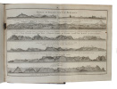
Beskrivelse over den Islandske Kyst og alle Havne fra Fugle-Skiærene og til Stikkelsholm i Brede-Bugten med Forklaring over deres Indseiling.
Kbhvn., 1788. 4to. Samt.hldrbd. Revne i ryg øverst og nederst. 3 kobberstukne vignetter(med landtoninger) bortklippet fra teksten. (4),72 pp. På skrivepapir. - Til værket hører løse kort, som ikke er med her. Foreliggende er: 1.Kaart over Torshavn. 2.Boesands Havn. 3.Kiible Wiig. 4.Waslösewiig. 5. Strömswiig. 6. Kaart over Havnefiord. 7. Kaart over Stoppens og Budenstads Reeder. 8. Kysten af Island ved Cap Reikianæs. 9. Udkast af rindewiigs Havn...(i teksten indtrykt). 1o. Fortoninger af Westlige og Nordwestlige Kyster..Denn sidste med skjold. Kortene måler 24x18-35 cm. - Fiske 368. Eksemplaret hos Fiske er heller ikke komplet.