 Write to the booksellers
5 books for « krusenstern a g »Edit
-
Century
19th (3)
20th (2)
-
Topics
Autographs (1)
Geography (1)
Translation (1)
Travel (3)
-
Countries
Denmark (2)
France (1)
Italy (1)
Switzerland (1)
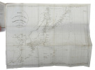
Beretning til Kaartet over Sonda Stræde samt Batavia Rehd (Translated from the French: ""Mémoire sur une carte du détroit de la Sonde et de la rade de Batavia"" - [DANISH MANUSCRIPT TRANSLATION OF KRUSENSTERN'S ""STRAIT OF SUNDA"", INCLUDING THE MAP]
København, 1820 (Original work published St. Pétersburg, 1813) 4to (190 x 258 mm). In later half cloth. Gilt lettering and stamp to front board. Two stamps to title-page. Manuscript in brown ink by Danish Rear Admiral Lövenørn. Fine and clean with text in very good and legible condition. (6), 32 pp. + coloured manuscript map of Strait of Sunda. Copy of Krusensterns 1813-map. (590 x 460 mm)
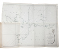
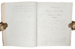
Danish Manuscript translation of Krusenstern's commentary to his of map of the Strait of Sunda and Batavia habour from 1813. We have been able to locate only one other copy of this work (also a Danish translation, from 1815, but lacking the map), manuscript and printed, in Danish, Swedish or Norwegian. Despite the fact that the Strait of Sunda was sailed relatively frequently by European sailors, Krusenstern's 1813-memoir is one of the earliest reliable pilots to this strait. From the present memoire: ""Although a strait so important as that of Sunda, frequented every year by more than 50 European ships, ought to be (as one would naturally suppose) perfectly well known"" notwithstanding which, after having examined the charts of these coasts reputed the best, I venture to say that I have been convinced that there does not exit one with which one can be entirely satisfied"". Rear admiral Lövenørn became the first director of Royal Danish Nautical Charts Archive in 1784.
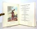
VIAGGIO INTORNO AL MONDO FATTO NEGLI ANNI 1803-4-5 E 1806.
D'ordine di Sua Maestà Imperiale Alessandro Primo su i vascelli la Nadeshda e la Neva. Tradotto dal tedesco dal sig. Angolini. Sonzogno Milano, 1818. In-16 gr. (mm. 180x110), 3 voll., brossura edit. (il 2° vol.) + mz. pelle coeva con ang., fregi e tit. oro al dorso, conserv. bross. muta coeva (1° e 3° vol.), pp. XLVI,255; 297; 377; con un ritratto dell'A. in b.n., 1 carta idrografica del viaggio del Sig. Krusenstern, più volte ripieg. e 7 (su 11) tavv. f.t. colorate d'epoca (con suite in bianco e nero a fronte), tutto inc. in rame. Volumi della Raccolta de' viaggi.. nelle varie parti del mondo.. dopo quelli di Cook, e non pubblicati fin ora in lingua italiana.Alone lungo il margine interno della copertina e prima carta del vol. 1°, altrimenti esempl. ben conservato, con barbe.
Voyage round the world in the years 1803, 1804, 1805, & 1806. By order of His Imperial Majesty Alexander the First, on board the ships Nadeshda and Neva, under the command of Captain A.J. von Krusenstern of the Imperial Navy. In two volumes.
Amsterdam / New York, Nico Israel / Da Capo Press, Bibliotheca Australiana. 1968. 2 volumes in-4, plein skyvertex, pièce de titre aux dos et aux premiers plats, rhodoïd. Microscopiques accrocs en bords de l'un des rhodoïds, pour le reste à l'état de neuf. Illustré de 2 planches couleurs et d'une carte dépliante.
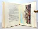
Fac-similé de l'édition de 1813. Volumes 38 et 39 de la Bibliotheca Australiana.
Reise um die Welt in den Jahren 1803, 1804, 1805 und 1806 auf Befehl Seiner Kaiserl. Majestät Alexanders des Ersten auf die Schiffen Nadeshda und Newa unter den Commando... von... A.J. von Krusenstern. 1.-2. Theil (in 3) [Langsdorff:] Nachricht über d... - [FIRST EDITION PUBLISHED IN GERMANY INCLUDING TWO LANGSDORFF ITEMS NOT PRESENT IN ALL COPIES]
Berlin, Haude und Spener, 1811-12. Small 8vo. Bound in 3 uniform contemp. marbled boards. Handwritten titlelabels on spines. Corners a bit bumped. A small stamp on title-pages. Engraved portrait as frontispiece. XLII,450,10(2),294(2),269 pp. + Publisher's Prospectus (8) pp. With 3 frontispieces of which 2 are handcoloured, 10 double-page folded engraved plates (of 11) and 1 large folded engraved map. Printed on good paper. Internally clean and fine.
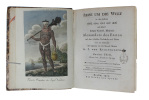
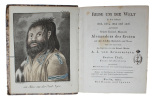
First edition published in Germany including two Langsdorff items not present in all copies. Grigory Langsdorff was a naturalist and physician on Kruzenshtern's voyage. The work includes view of Nagasaki Harbour, one of the earliest views of Japan published in the west as well as views of Nukahiva, Japan, Macao, Canton, St Helena and St Catherine, Brazil.Two extra piece was added by the publisher in the form of the Nachricht by Langsdorff on the practice of tattooing in Nuku Hiva and the Washington islands, including a small woodcut showing the instruments used and finally a Prospectus by Langsdorff and his publisher for the German publication of his Bemerkungen.Arctic Bib. 9378AForbes 421.Lada-Mocarski 61 and 62 (St. Peterburg-edition)
Atlas van een reis om de wereld 1803-1806.
1996 16 p., title-page, ca. 105 pls & maps, portrait, roy. 4to, cloth (dust jacket). Facsimile of the ''Atlas zur Reise um die Welt'' originally published in 1814. With an introduction by F. Pelt.