 Write to the booksellers
2 books for « breislak scipione »Edit
-
Topics
Geology (1)
History (1)
-
Countries
France (1)
Italy (1)
-
Syndicate
ILAB (2)
SLAM (1)
Atlas géologique ou vues d'amas de colonnes basaltiques, faisant suite aux Institutions géologiques de Scipion Breislak.
Milan, 1818.
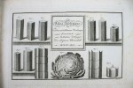
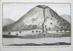
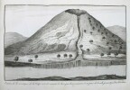
Première édition. Cet atlas contient un avis au lecteur, un titre illustré et 55 planches. Il est complet. Ces planches sont très belles et spectaculaires. L'atlas a été publié en complément des "Institutions géologiques" de Breislak (1818). Mais comme on trouve très souvent cet atlas seul, il est plus que probable qu'il se vendait séparément. Le géologue italien Scipione Breislak fut l'un des premiers à se convertir au vulcanisme. "La fascination de Breislak pour le basalte l'a conduit à publier en 1818 un atlas géologique contenant 53 vues de formations basaltiques, de la Chaussée des Géants en Irlande à la grotte de Fingal dans les Hébrides écossaises, en passant par le Vivarais en France et les collines euganéennes de la Vénétie". On y trouve aussi 4 planches de vues de l'île de Bourbon (La Réunion). Reliure un peu frottée. /// In-4 oblong de (1) f. d'avis, 1 titre gravé, 55 planches gravées. Demi-basane, dos orné. (Reliure de l'époque.) //// First edition. This atlas contains a note to the reader, an illustrated title and 55 plates. It is complete. The plates are beautiful and spectacular. This atlas was published as an addition to Breislak's Institutions géologiques (1818). But as it is very often found on its own, it is more than likely that it was sold separately. The Italian geologist Scipione Breislak was an early convert to vulcanism. "Breislak's fascination with basalt led him to publish a geological atlas in 1818 that contained 53 views of basalt formations, from the Giants Causeway in Ireland to Fingal's Cave in the Scottish Hebrides to the Vivarais in France to the Euganean hills in the Veneto of Italy." (W. Ashworth, Linda Hall Library). Binding slightly worn.
DESCRIZIONE GEOLOGICA DELLA PROVINCIA DI MILANO.
Pubblicata per ordine dell'I.R. Governo di Lombardia. dall'Imperiale Regia Stamperia, Milano, 1822. In-8 gr. (mm. 243x158), mz. pelle coeva (abras. alle cerniere), dorso a cordoni con fregi e titolo oro, pp. XLIX,260, con una grande carta geografica (più volte ripieg. e fuori testo) che raffigura parte della Lombardia austriaca compresa tra l'Adda e il Ticino, disegnata da G. Sarti. Nell'opera: De' ciottoli e massi erratici, detti in Lombardia trovanti' - delle ghiaie, argille, pudinghe, sostanze metalliche - tufi calcari e torbe - ossa fossili - dei monti della Brianza - osservazioni sulle colline di S. Colombano e della Stradella. "Prima edizione". Cfr. Predari, p. 28 - Cat. Hoepli,569. Esempl. con barbe, su carta distinta, ben conservato.