 Write to the booksellers
3 books for « bowen emanuel »Edit
-
Type
Book (2)
Maps (1)
-
Topics
Europe (1)
Geography (1)
Maps (1)
-
Countries
France (2)
Switzerland (1)
-
Syndicate
ILAB (3)
NVVA (1)
SLACES (1)
SLAM (1)
Map of Middlesex, from Britannia Depicta by Thomas Bowles.
London Thomas Bowles 1720
Copper engraving by Emanuel Bowen published in the pocket road book 'Britannia Depicta' by Thomas Bowles from 1720. This was the first truly pocket sized road book for the traveller based on the surveys of John Ogilby published in large folio format 45 years earlier in 1675. The plates were printed on both sides of the paper, reducing the weight of the volume which required considerable organisation for the process of copperplate printing as the ink required an extensive drying-off period. The notes by John Owen were engraved by Emanuel Bowen on the copperplate surrounding the road maps and also on separate plates. The maps have become commonly known as "Owen & Bowen" maps. The map is set below a decorative cartouche containing the title for the road from London to Bristol with the final part of the road from London to Berwick verso. 190 x 120 mm (7œ x 4Ÿ inches).
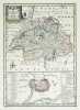
[YORKSHIRE] An accurate map of the East Riding of York Shire divided into its wapontakes &c.
Londres, John Bowles & Son, & Rob.t Sayer, [circa 1750]. 525 x 652 mm.
Belle carte du comté du Yorkshire de l'Est ou East Riding of Yorkshire, au nord-est de l'Angleterre. Elle a été dressée par le graveur et marchand britannique Emanuel Bowen, et publiée par Thomas et John Bowles à Londres vers 1750. Elle est ornée d'un beau cartouche de titre, d'un cartouche de dédicace à Arthur Ingram, 6e vicomte d'Irvine et Lord-lieutenant du East Riding of Yorkshire de 1726 à 1738, orné des armoiries du dédicataire, et d'une vue panoramique de Kingston-upon-Hull, plus grande ville du comté. En haut à droite figure une carte réduite du comté. Le comté est divisé en wapontakes ou wapentakes, terme désignant des subdivisions. La carte est accompagnée de notes sur les produits naturels du comté, ses mines, minéraux, ses productions, son commerce et l'état actuel de ses villes principales. Bel exemplaire, dont les cartouches et le panorama ont été finement aquarellés à l'époque. The Yorkshire Archæological Society, A descriptive list of the printed maps of Yorkshire and its Ridings, 1577 - 1900, 1971, p. 66 (pour l'édition publiée par J. Hinton).
![[YORKSHIRE] An accurate map of the East Riding of York Shire divided into its wapontakes &c.. BOWEN (Emanuel).](https://static.livre-rare-book.com/pictures/LBW/lbw-7675_1.jpg)
![[YORKSHIRE] An accurate map of the East Riding of York Shire divided into its wapontakes &c.. BOWEN (Emanuel).](https://static.livre-rare-book.com/pictures/LBW/lbw-7675_1_thumb.jpg)
A new & accurate map of Switzerland with its Allies and Subjects. Composed from the most approved maps &c. and regulated by astronom. observations.
(1744), 32.5 x 23 cm, carte gravée coloriée à la main avec petit plan de la ville de Genève, coin inf. droite froissé, 1 feuille (42 x 28 cm).
Carte publiée dans: Emanuel Bowen, A complete system of geography. Being a description of all the countries, islands, cities, chief towns, harbours, lakes, and rivers, mountains, mines, &c. of the known world ... In two volumes, London, 1747. Blumer 206. Image disp.
(SLACES, NVVA)
Phone number : 41 (0)26 3223808