 Write to the booksellers
JAILLOT (Alexis Hubert).
Atlas nouveau contenant toutes les parties du monde, ou sont exactement remarqués les empires, monarchies, royaumes, estats, republiques & peuples qui sy trouvent & present.

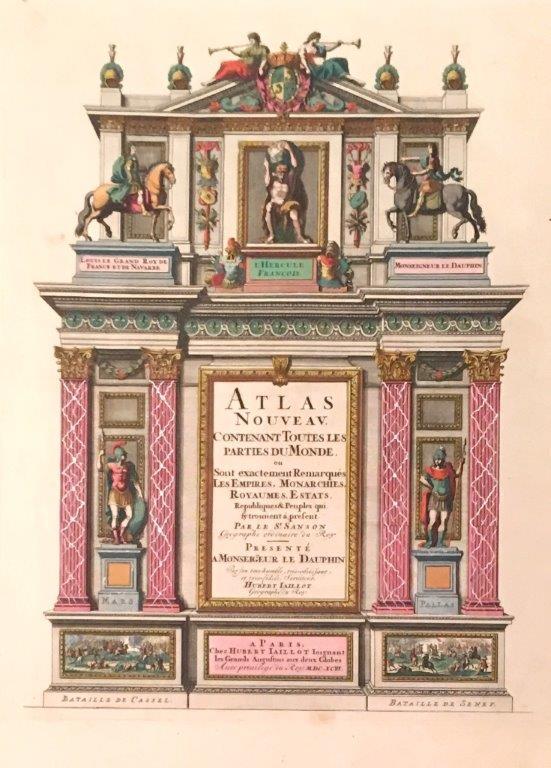

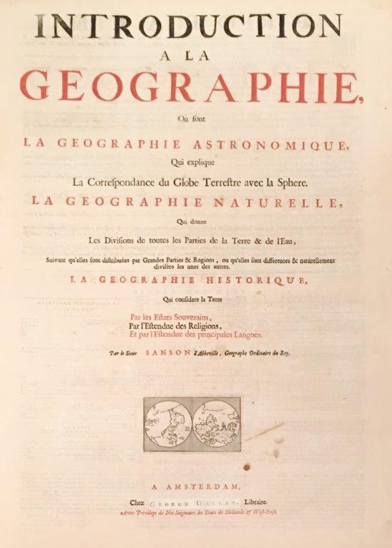

Paris, Hubert Jaillot [Amsterdam: Pierre Mortier], 1696. 1696 2 vol. in-plano (655 x 522 mm.) de : I. 1 table manuscrite ; [3] ff. (titre et table gravés en coloris, titre à lencre rouge et noir avec vignette gravée en coloris) ; 45 cartes en coloris (dont 42 sur double page, 2 à pleine page et 1 dépliante) ; [13] ff. (planches gravées dans plans des villes ; 1 plan gravé sur double page de Paris et sa table ; [45] ff. (tables des cartes). II. 1 table manuscrite, [1] f. (titre gravé en coloris) ; 57 cartes en coloris (34 sur double page dont une très grande dépliante) ; [11] ff. (planches gravées des plans des villes) ; [58] ff. (tables des cartes). (Petites traces de mouillures à la base du vol. 1). Plein veau dépoque, dos à nerfs orné, titre de maroquin rouge, encadrement de filets dorés sur les plats avec motif central représentant une sphère armilaire dans un entrelat végétal. (Défauts d'usage, coins et coiffes anciennement restaurés, marquage du cuir aux gardes et contre-gardes et petites taches brunes à la base du volume 1).
Reference : 4154
Bel exemplaire en coloris dépoque de la seconde édition de cet atlas par Mortier. L'éditeur d'Amsterdam Mortier vécut à Paris entre 1681 et 1685. Il connaissait bien les cartes de Sanson / Jaillot. Mortier et Huguetan publient trois éditions successives de leur contrefaçon de lAtlas Nouveau. Les deux premières sont de 1692 et de 1696. La première édition reproduit fidèlement louvrage français, et le nom de Mortier ny figure en aucun endroit. La majeure partie des cartes de lAtlas Nouveau de Mortier et Huguetan sont des contrefaçons fidèles des cartes de lédition française. Mortier singénie a compléter et à développer lAtlas Nouveau: 99 cartes en 1692, 111 en 1696 et 168 dans la dernière édition. L'Atlas comprend une carte du monde Mappe-Monde Géo-Hydrographique, ou Description Générale du Globe Terrestre et Aquatique en Deux-Plans Hémisphères qui montre la Californie comme une île, et des parties de la Nouvelle-Zélande et de l'Australie. « Les deux hémisphères sont dessinés à l'échelle agrandie, gravés avec distinction, et généralement imprimés sur du papier de grande qualité. » 2 vol. in-plano. (655 x 522 mm.) of: I. 1 manuscript table; [3] ff. (title and table engraved in colors, title in red and black ink with vignette engraved in colors); 45 color maps (including 42 on double page, 2 full page and 1 foldout); [13] ff. (plates engraved in city plans; 1 plan engraved on double page of Paris and its table; [45] ff. (tables of maps). II. 1 manuscript table, [1] f. (title engraved in color); 57 color maps (34 on double page including a very large foldout); [11] ff. (engraved plates of town plans); [58] ff. (tables of maps). (Small traces of wetness at the base of the flight . 1).Full period calf, decorated ribbed spine, red morocco title, gilt fillet frame on the boards with central motif representing an armilar sphere in a vegetable tracery.(Usage defects, corners and caps formerly restored , marking of the leather on the guards and counter-guards and small brown spots at the base of volume 1). Fine copy in period colors of the second edition of this atlas by Mortier. The publisher of Amsterdam Mortier lived in Paris between 1681 and 1685. He knew the maps of Sanson / Jaillot well. Mortier and Huguetan publish three successive editions of their counterfeit Atlas New. The first two are from 1692 and 1696. The first edition faithfully reproduces the French work, and the name of Mortier does not appear in any place. Most maps of the New Atlas of Mortier and Huguetan are faithful counterfeit maps of the French edition. Mortier strives to complete and develop the New Atlas: 99 maps in 1692, 111 in 1696 and 168 in the last edition. The Atlas includes a map World Map-World Geo-Hydrographic, or General Description of the Earth Globe and Aquatic Two-Plan Hemispheres. [Amsterdam,] 1691, shows California as an island, and parts of New Zealand and Australia. The two hemispheres are drawn on an enlarged scale, engraved with distinction, and usually printed on high quality paper. Copy preserved in its very nice original binding.
Bookseller's contact details
J-F Letenneur Livres Rares
M. Jean-François Letenneur
11 bd du tertre Gondan
35800 Saint Briac sur Mer
France
librairie@jfletenneurlivresrares.fr
06 81 35 73 35