‎BLAEU (Johannes);‎
‎ [VIRGINIE] Nova Virginiae tabula.‎

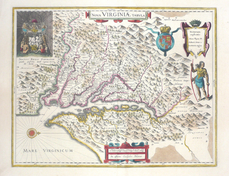
‎Amsterdam 1643-1650 376 x 481 mm.‎

Reference : LBW03574


‎ L'une des plus belles cartes de la Virginie de la première moitié du XVIIème siècle, et l'une des premières cartes détaillées de la baie de Chesapeake. Elle est dérivée de la carte de John Smith de 1612, publiée une première fois en 1618 par Hondius, puis par Blaeu. En haut à gauche figure une représentation du chef indien Powhatan se préparant à recevoir le captif John Smith. Texte français au verso. Mouillure claire affectant le rebord de la marge droite, sinon bel exemplaire brillamment colorié à l'époque.‎

€3,000.00 (€3,000.00 )
Bookseller's contact details

Librairie Le Bail
Didier Le Bail
13 rue Frédéric Sauton
75005 Paris
France

librairie.lebail@orange.fr

33 01 43 29 72 59

Contact bookseller

Payment mode
Others
Cheque
Others cards

Contact bookseller about this book

Enter these characters to validate your form.
*
Send
Get it on Google Play Get it on AppStore
The item was added to your cart
You have just added :

-

There are/is 0 item(s) in your cart.
Total : €0.00
(without shipping fees)
What can I do with a user account ?

What can I do with a user account ?

  • All your searches are memorised in your history which allows you to find and redo anterior searches.
  • You may manage a list of your favourite, regular searches.
  • Your preferences (language, search parameters, etc.) are memorised.
  • You may send your search results on your e-mail address without having to fill in each time you need it.
  • Get in touch with booksellers, order books and see previous orders.
  • Publish Events related to books.

And much more that you will discover browsing Livre Rare Book !