 Write to the booksellers
RUSCHA EDWARD (né en 1937)
Me and The

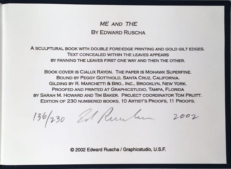

2002 Tampa, FL: Graphicstudio, U.S.F., 2002, 133x182x56mm, 576 pages non paginées, tranches dorées, relié sous couverture toilé bleu nuit.Signé et numéroté au colophon 136/230 +21 AP. (104213)
Reference : 104213
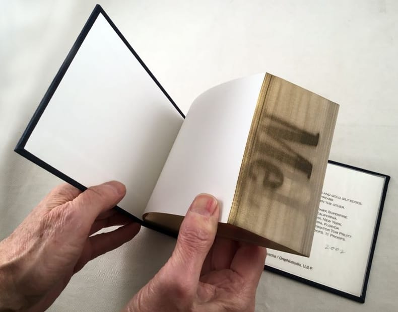
Un "Livre sculptural" signé par Ruscha, les mots "Me" et "The" imprimés sur la gouttière du bloc de texte qui apparaissent lorsque l'on courbe les feuilles d'abord dans un sens puis dans l'autre. Une feuille d'information de l'éditeur et jointe. État neuf.
Bookseller's contact details
Librairie Chloé et Denis Ozanne Déesse sarl
M. Denis Ozanne
21 rue Monge
75005 Paris
France
+33 1 48 01 02 37
Payment mode


Sale conditions
Conforme aux usages de la librairie ancienne et moderne, tous les ouvrages présentés sont complets et en bon état, sauf indication contraire. L'exécution des commandes téléphonées est garantie mais sans règle absolue, la disponibilité des livres n'étant pas toujours vérifiable lors de l'appel. Les frais de port sont à la charge du destinataire. Les livres sont payables à la commande. Nous acceptons les règlements par chèque bancaire ou postal, mandat postal ou international, carte bancaire, Visa, Eurocard, MasterCard et virements bancaires dans certaines conditions.
5 book(s) with the same title
The Legacy
Dutton / Signet 1999 373 pages 16 8x10 9x3 1cm. 1999. Broché. 373 pages. The central feature of this Stephen Frey novel is a fascination with the Kennedy assassination and the answer that conspiracy junkies have long believed: that the United States government has been involved in covering up the existence of a second gunman ever since that fateful day in November 1963. In Frey's world while the government was not responsible for the assassination the belief that evidence of a conspiracy would have pushed the Cold War into a hot one "forced" those at the top to keep that evidence to themselves. The novel's prologue sets the stage as a struggling actress goes to Dallas and films the motorcade on a whim. Before she has even digested that she has captured one of the most memorable moments in American history her camera is ripped from her grasp by a mysterious man. The chapter that follows jumps to 1998 as New York bonds trader Cole Egan receives a phone call telling him of his estranged father's death and of a package that awaits him in a safety deposit box. The package of course contains a video of the film stolen from the actress and Cole realizes he is sitting on a gold mine: from the other side of Dealey Plaza the tape shows the firing rifle denied by the Warren Commission. Of course the U.S. government has not gone to all the trouble of keeping such information secure for over 30 years just to let some upstart indebted bonds trader make a fortune selling the truth to the highest bidder. The novel takes flight as the dashing and resourceful Cole begins his quest to receive the benefits of his legacy while competently evading the knives guns and explosives of a super secret government agency. Not only is the government (portrayed as a surprisingly well-organized structure) intent on controlling the truth so are those who might be accused of the assassination. Although Cole is initially confident about who the bad guys are the suspense builds as the line separating allies and enemies dissolves and our hero finds out quite a lot about himself his father and the lengths to which the government will go to keep its secrets. --Kimberly Crouch
Bon Etat
The Starr Report: The Independent Counsel's Complete Report to Congress on the Investigation of President Clinton
Pocket Books 1998 523 pages poche. 1998. broché. 523 pages. Here it is--the result of four years of investigative research at an approximate cost of $40 million. Back in 1994 Kenneth Starr was appointed to investigate a series of investments made by Bill and Hillary Clinton; the Whitewater allegations never bore fruit but then somebody whispered stories about the president and an intern named Monica Lewinsky into Starr's ear. He and his team of prosecutors sniffed around and this is what they've come up with: "According to Ms. Lewinsky she and the President had ten sexual encounters eight while she worked at the White House and two thereafter." The details are bathetic in their precision: "during many of their sexual encounters " Starr notes "the President stood leaning against the doorway of the bathroom across from the study which he told Ms. Lewinsky eased his sore back." And yes as far as we know that was the president's semen on Monica's navy dress. Whether or not it's the government's job to produce hackneyed narratives about young women who find themselves falling in love with powerful men is for voters to decide but this story would be rejected outright by readers of Harold Robbins or Jackie Susann were it not for the newsworthy elements. Of course there's also the second half of the report in which Starr explains how Clinton's attempts to prevent his relationship with Lewinsky from becoming public knowledge constitute grounds for his impeachment. That's the part of the document that matters most from a political perspective ... but it's doubtful that it'll be the part that lingers in historical memory. (Note: You can also read the Starr report in electronic form for free at a number of locations on the Web including the Library of Congress site and the commercial sites AOL.com Netscape Netcenter and Yahoo!)
Bon Etat-bords de la couv un peu frottés
The Armies Of The First French Republic and the Rise of the Marshals of Napoleon. In Five Volumes. Volume One: The Armee Du Nord. Volume Two: The Armees De La Moselle Du Rhin De Sambre-Et-Meuse De
Oxford university press in8. Sans date. Cartonné. 4 volume(s). The Armies Of The First French Republic and the Rise of the Marshals of Napoleon. In Five Volumes. Volume One: The Armee Du Nord. Volume Two: The Armees De La Moselle Du Rhin De Sambre-Et-Meuse De Rhin-Et-Moselle. Volume Three: The Armies In The West 1793 to 1797 and The Armies in the South 1792 to March 1796. Volume Four: The Army of Italy 1796 to 1797 Paris and the Army of the Interior 1792 to 1797 and The Coup D'Etat of Fructidor September 1797. !!!!VOLUME 5 MANQUANT/MISSING
Bon état volume I à IV édités entre 1926 et 1932 (VOLUME V manquant) couverturess défraîchies intérieurs propres nombreuses cartes dépliantes
( Revue Rock & Folk ) - Johnny Hallyday - Jerry Lee Lewis - The Who - Junior Walker - Los Bravos - The Beach Boys - Gene Vincent - The Moody Blues - Cat Stevens - The Cream - Avoine - Cabu - Serge Dutfoy - Collectif.
Reference : 32430
Mensuel Rock & Folk, numéro 2 de décembre 1966 : Johnny Hallyday - Jerry Lee Lewis - The Who - Junior Walker - Los Bravos - The Beach Boys - Gene Vincent - The Moody Blues - Cat Stevens - The Cream.
Revue Rock & Folk n° 2 de décembre 1966. In-4 agrafé de 66 pages, au format 27 x 21,5 cm. Couvertures photographiques avec Johnny Hallyday et Jerry Lee Lewis. Couvertures avec d'infimes frottis aux coins. Intérieur frais. Mensuel musical français consacré à la musique rock et pop, fondé en 1966 par Robert Baudelet, Jean Tronchot, Philippe Adler, Jean-Pierre Leloir et Philippe Koechlin. La revue connut la participation de nombreux photographes dont : Jean-Pierre Leloir, Claude Gassian, Pierre Terrasson, Gaëlle Ghesquière, Bruno Ducourant,Patrice Guino, Jean-Louis Rancurel, Dominique Tarlé, Bertrand Alary et Saddri Derradji. Nombreux articles sur le Rock, le blues, la soul, la pop dont : Johnny Hallyday, Jerry Lee Lewis, The Who, Junior Walker, Los Bravos, The Beach Boys, Gene Vincent, The Moody Blues, Cat Stevens, The Cream. Nombreuses chroniques avec de très nombreuses photographies en noir et blanc. Dessins en noir de Avoine, Cabu et Serge Dutfoy. Rarissime édition originale, en très bel état de fraicheur de ce mythique n° 2.
Vente exclusivement par correspondance. Le libraire ne reçoit, exceptionnellement que sur rendez-vous. Il est préférable de téléphoner avant tout déplacement.Forfait de port pour un livre 10 € sauf si épaisseur supérieure à 3 cm ou valeur supérieure ou égale à 100 €, dans ce cas expédition obligatoire au tarif Colissimo en vigueur. A partir de 2 livres envoi en colissimo obligatoire. Port à la charge de l'acheteur pour le reste du monde.Les Chèques ne sont plus acceptés.Pour destinations extra-planétaire s'adresser à la NASA.Membre du Syndicat Lusitanien Amateurs Morues
( Littérature en Anglais - Bandes Dessinées - Illustrations - Western ) - E.M. Jackson - Mario Cooper - The Demise of the Frontier and the birth of the New " Old West ".
Reference : 32177
(1983)
Illustration, volume 16, issue number sixty-three, 2019 : E.M. Jackson - Mario Cooper - The Demise of the Frontier and the birth of the New " Old West ".
Etats-Unis, Illustration Magazine 2019. In-4 broché de 96 pages au format 28 x 21,5 cm. Couverture illustrée par E.M. Jackson. Dos carré. Plats et intérieur frais. Numéro spécial de cette revue d’art consacré aux artistes et illustrateurs américains suivants : E.M. Jackson - Mario Cooper. Essai sur les dessinateurs et l'art " Western ", intitulé he Demise of the Frontier and the birth of the New " Old West ". Textes en anglais accompagnés d'une foultitude d'illustrations en couleurs et en noir. Edition originale en superbe état de fraicheur. Epuisé. Rare.
Vente exclusivement par correspondance. Le libraire ne reçoit, exceptionnellement que sur rendez-vous. Il est préférable de téléphoner avant tout déplacement.Forfait de port pour un livre 10 € sauf si épaisseur supérieure à 3 cm ou valeur supérieure ou égale à 100 €, dans ce cas expédition obligatoire au tarif Colissimo en vigueur. A partir de 2 livres envoi en colissimo obligatoire. Port à la charge de l'acheteur pour le reste du monde.Les Chèques ne sont plus acceptés.Pour destinations extra-planétaire s'adresser à la NASA.Membre du Syndicat Lusitanien Amateurs Morues